
Crossing Ginninderra Creek at the Barton Highway roundabout
Sunday 23 October 2022: Canberra Centenary Trail – Section 4 – Hall to Black Mountain * – L/E,ptX. Perhaps begin with an egg and bacon roll at Daughters@Hall. They open at 6.30am. Head SE from Hall through Federation Square, with side trips up Harcourt Hill and Percival Hill. SW to Lake Ginninderra and the John Knight Memorial Park. Up to Gossan Hill. East through the Australian Institute of Sport, then along the main shared path between O’Connor Ridge and Bruce Ridge Nature Reserves. South to finish at Frith Road at the bottom of Black Mountain. Around 22km and 400vm climb. Limit 12. Early morning assistance required from one (or more, depending on number of walkers) driver/s to set up car shuttle, prior to start of walk.
Summary
From Garmin Connect – Distance: 21.97km | Climb: 430m | Time: 4:18 moving + 0:39 of stops = 4:57 | Grading: L/E;ptX,W; M(10).
Photographs Photographs are available here.
gpx File The gpx file is available here.
Relive the trip
Track Notes
I was last on this section of the Canberra Centenary Trail on 19 Oct 13 and 4 Aug 12.
A few wins and many fails today.
Wins – amazing views of Ginninderra Creek in flood. Car shuttle worked, no walkers or cars left over. Good coffee at Sugar Plum Fairy Cakes at 7.35am for early car shuttlers (DatH not open until 8am). Good to have backup navigators in the party, that’s why I share my proposed route with others (thank you TL, Mike). Seriously, use local knowledge from fellow walkers when you run a trip (thank you Marianne for Belconnen clues and Jenny for Bruce Ridge NR). The ‘flooding rains’ held off.
Fails – GPSr seemed to be playing up a bit, didn’t get it started for the first few hundred metres, probably user error. Absolutely missed Harcourt Hill! Many other woopsies which made this pedant uneasy as poor navigation or water forced us off the CCT ;-). I’d rather walk in the bush without so many turn options and no one knows if you’re off track, as long as you get to the next bound. Couldn’t successfully mask navigation errors as trip flexibility!
We started walking on time at 8am. Immediately off the CCT route, but who cares (except me). Out of Hall and along side Victoria Street to the Barton Highway. Running water and puddles immediately. I was talking too much and missed Harcourt Hill (see purple planned route in map segments below). Uninteresting going, unless one hasn’t been along here before, continued as we walked through Gold Creek Village.
A sealed service road took us up towards Percival Hill (I thought I was going up Harcourt Hill for a while till I recognised features from 23 Jul 22). Topped at the trig.

Percival Hill
I’d planned to come down off-track to the south. We looked down on Ginninderra Creek and saw it in wide flood. I wrongly assumed we’d have to cross it (impossible) to get back onto the CCT and under the Barton Highway. So we returned down the way we came up.
Orchids and other flowers about during the day.

Bulbine lily on Percival Hill
Another booboo when we got down near the Barton Highway. I turned left, instead of right which would take us back to the bike path beside the Highway. We ended up north of Ginninderra Creek with a swift running drain between us and the Highway on our west.
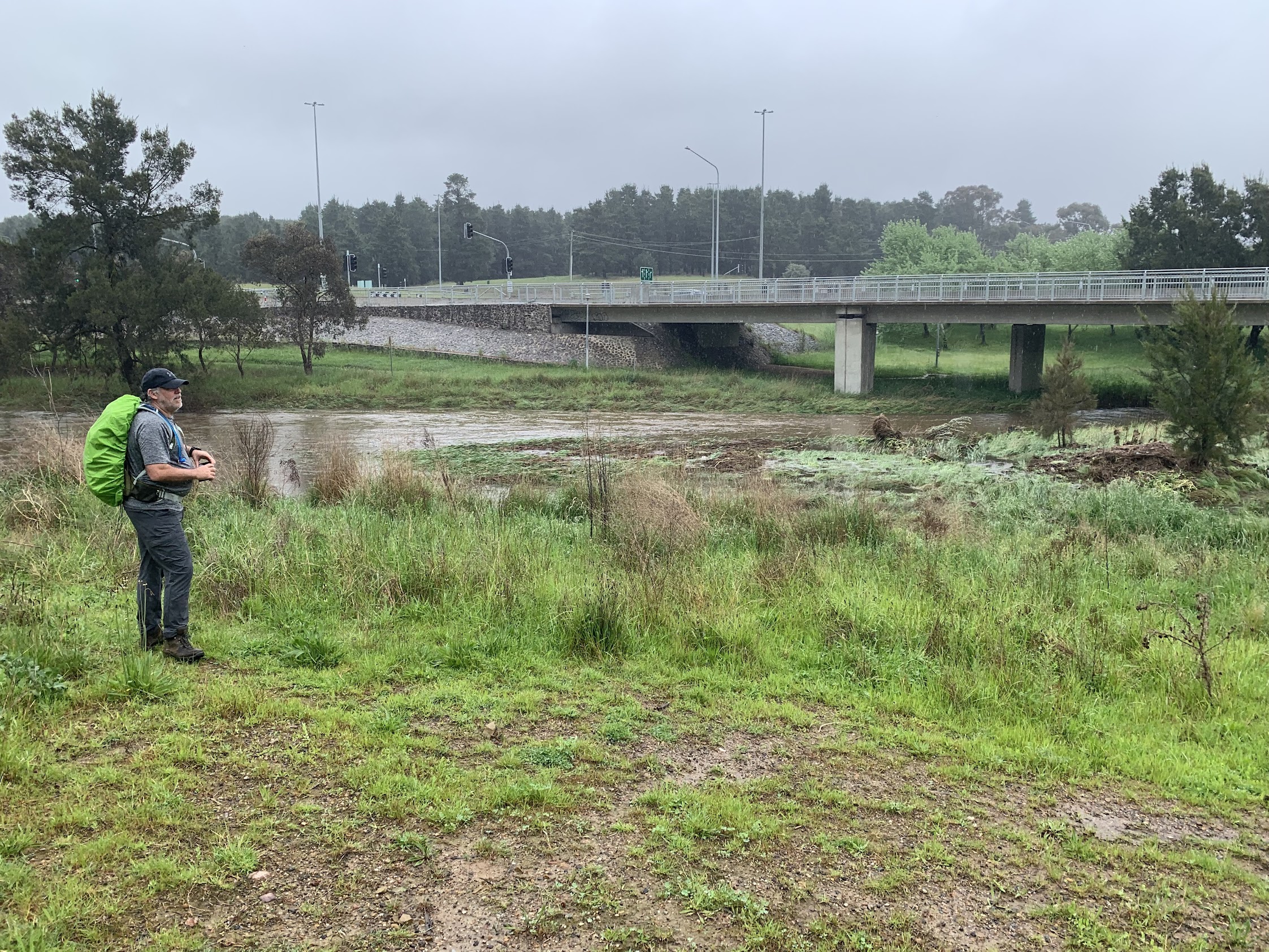
Ginninderra Creek
Stymied I thought, after inspecting the drain, and up for a 500m retrace of our steps. But with braver party members than I, we jumped the drain. Thanks Mike.

Crossing a drain beside the Barton Highway
Back up on the bike path immediately beside the road, it was a piece of cake to circle through the underpass near the major Barton Highway, Gundaroo Drive-William Slim Drive roundabout. There were even views back up to Percival Hill that showed we could have come down off-track to passageways through the fence.

Southern flank of Percival Hill
I was happy to be back on the CCT.

Southern flank of Percival Hill over Ginninderra Creek
Ginninderra Creek continued to rage.

Ginninderra Creek powering along beside William Slim Drive at the roundabout
We followed the west, then east, side of William Slim Drive, paralleling our favourite creek. Another little woopsie shows on the map, as I got off-route again because of William Slim Drive duplication construction. We headed back towards that creek, towards a crossing with handrails only showing. Reversed. Under at Baldwin Drive.

Ginninderra Creek at the Baldwin Drive underpass
From here, Marianne guided us. A relevant sign.

The story of the day – signage beside William Slim Drive
Safely over then under one of the Ginninderra Drive bridges and down to the John Knight Memorial Park for smoko.
That was a fun time. Sitting at a picnic table shelter, it was like Alfred Hitchcock’s film The Birds. The ravens were replaced by insistent Mynars which harassed us whilst we ate. That’s what happens when people feed wildlife.
Away again at 10.55am to near Emu Bank.

Swan family beside Emu Bank footbridge
South along Eastern Valley Way, east along College Street to cross and gain the Gossan Hill Nature Reserve. I missed the SH667 in the open which has the better view and found the scrubby Gossan Hill at 669m. Across the back of Radford College and crossed Haydon Drive.
Here, Jenny took over with her local knowledge and guided us through more enjoyable bushland in Bruce Ridge NR, rather than through the AIS.
Today’s big butt.
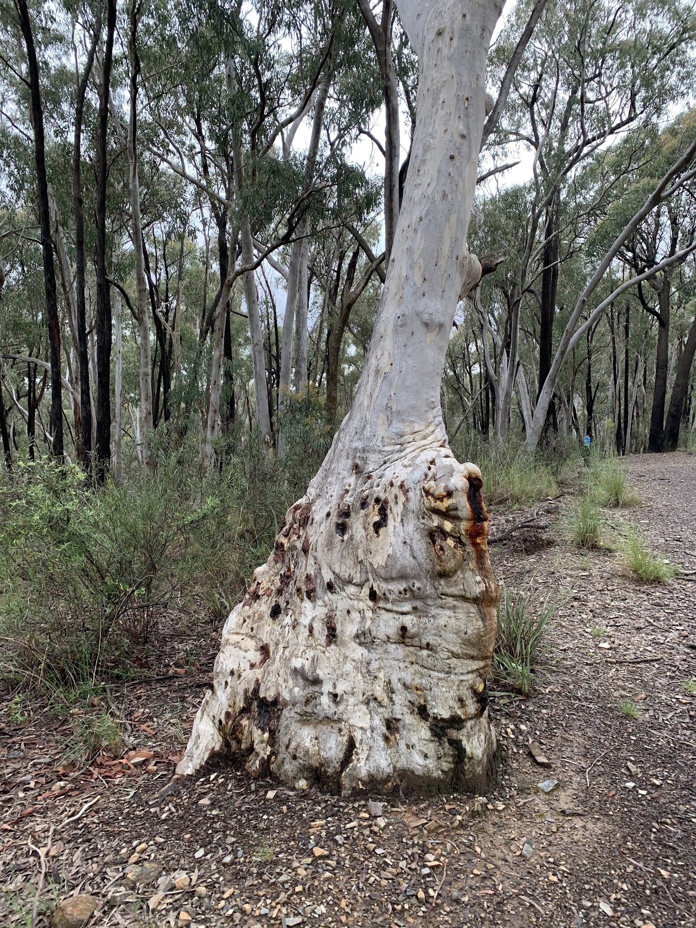
Today’s big butt
It was around 12.30pm when we hit the main bike path between O’Connor Ridge and Bruce Ridge NRs. With less than an hour to go and our good fortune holding with no rain, we had a standing snack and pressed on.
Down to Dryandra Street, across Fairfax Street and along under Barry Drive. Some severe erosion on the track.

CCT erosion between Dryandra St and Barry Dr
Under Barry Drive, paralleled Frith Road and there we were. Finished.
A great pace, average moving speed 5.1kph, average speed (distance with time including our morning tea break) 4.9kph. Brownie points for me getting home early. Thanks to TL and Mike, the car shuttle completed back to Hall. Second of 5 CCT sections ticked off.
Track Maps
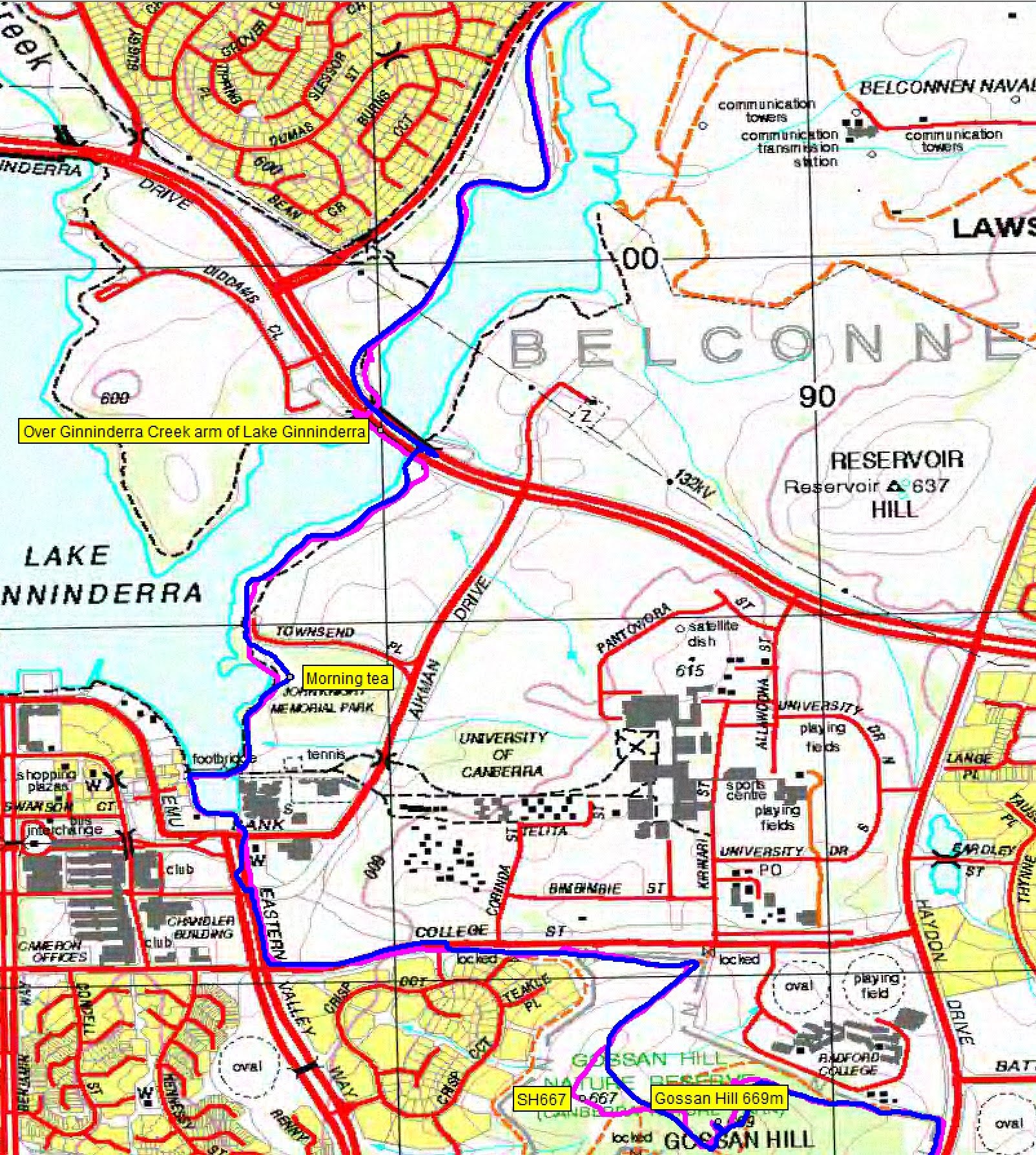
Here’s where we went. Topoview 2006 maps, so a few roads and suburbs missing. Planned route in purple, actual in blue.

Track overview CCT 4

Track 1 CCT 4

Track 2 CCT 4
Track 3 CCT 4

Track 4 CCT 4
Party
8 walkers. Jenny A, Marianne B, Mike B, Paula F, Teresa H, Tanya McS, Terrylea R, me.
Information Bit(e)s
I’ve had a lot of assistance from walking friends recently. By way of paying a bit back, I’ll publish a few bites of information that may help someone. Today’s is ‘5 Measure Magnetic and Grid Bearings‘.