
Lovely going just S of Little Ginini Mountain
Wednesday 19 October 2022: Combined clubs’ M-H Wednesday Walk. Pryors Hut/Little Ginini Mountain from Corin Dam. The walk starts at Corin Dam via a steep track (climbs 500m in 2 km) up Stockyard Spur through a delightful forested area to the helipad and then on an undulating track through alpine area to the Mt Franklin road. It’s then another 1 km to Little Ginini Mountain (2km off-trail – through open bush – gaiters and gloves for this section). Returning via Pryors Hut.
Summary
From Garmin Connect – Distance: 17.14km | Climb: 1100m | Time: 4:50 moving + 2:38 of stops = 7:28 | Grading: L/E-M; H(12).
Photographs Photographs are available here.
gpx File The gpx file is available here.
Relive the trip
Track Notes
I was last in this area on 26 Mar 22.
As in a couple of other Wednesday Walks, I asked for the leader’s nod to begin early by myself. Granted. I left home around 7.30am, so about an hour ahead of the rest of the party leaving Kambah at 8.30am. Thankfully, Point Hut Crossing open.
A few wallabies on Corin Road, so a slow drive. Another car at the car park and I met the occupants coming back from Pryors Hut and Mt Gingera as I walked in. Started walking at 8.05am.
I was at the opening of the staired Stockyard Spur track, when it was explained that the stone steps at the start represent the ‘risers and treads’ of the walk up to the helipad.

Steps at start of Stockyard Spur climb
Discounting the top ‘tread’, I see 3 other ‘treads’. I reckon these correspond to the short ‘treads’ between the tall ‘risers’ (ie. the significant climbs that make me huff and puff and gasp). Except the second ‘tread’ has two less significant short flats on the climb.

‘Tread 1’

‘Tread 2’

‘Tread 2.5’

‘Tread 3’
Anyway, that’s my story. At last the helipad appeared. This leg 2.3km in 1hr 22mins, climbing 525vm. More than a few pauses, so I was glad I didn’t embarrass myself in the main party.

Stockyard Spur helipad
Delightful walking on the next bound to the lookout spots. First, off the track to the right, where there are views to the NW and Mt Ginini.

View NW to Mt Ginini
Then across the other side, which Graeme Barrow (the author of many books on walking near Canberra before he died) named ‘Stockyard Spur Grandstand’.

View from ‘Stockyard Spur Grandstand’ lookout to Mt McKeahnie and the SE
The next point of interest is the brumby yard site, 200m further on. Not much left except a bit of wire.

Remnant brumby yard
From here, 750m down the spur to the intersection with the Mt Franklin Road. I arrived at 10.50am.
I had a bit of a poke about where there used to be a weather station nearby. Not there any more. Returning, I ran into Sal and Jenny, enjoying a trip to Pryors Hut. I had morning tea, wandered around a bit more, listened to some music. Popped some extra layers on in the dappled shade.
Phillip and six others arrived spot on 12noon. They had a swig of water, we all gaitered up, then headed directly west up to Little Ginini Mountain. Easy going through open woodland, starting at a vague footpad near the track junction signage. Whether you were a two ‘l’ Phillip or a one ‘l’ Philip, they and the others took off like startled rabbits up the hill. I was so glad I didn’t walk up Stockyard Spur with them!
All seven were at the top when I arrived, although I had stopped to regain my breath at the nearby border marker M7. It’s a delightful marker, a 1″ GIP (one inch galvanised iron pipe) buried at ground level in a small stone box at the centre of the lockspit.

Walkers on Little Ginini Mountain
Absolutely delightful walking south from the top. Snow gum woodland with snow grasses underfoot. My companions humored me by visiting border markers O57 (described by Harry Mouat in his field notebook as “3” Downpipe Concrete Core and Cairn – Station on knob Shist [sic] outcrop”) and P57.

Border marker O57 3″ Downpipe Concrete Core and Cairn – Station on knob Shist [sic] outcrop

Border marker P57 Downpipe and Cairn
Nice views from P57.

View SE from P57 over Snowy Flats to Mt Namadgi
Arrived at Pryors Hut and sat down to lunch.

Pryors Hut
I’d sometimes heard of parties camping down behind the hut and Lorraine kindly gave me some relevant information. So I took a wander down past the toilet to join the vehicle track that circumnavigates the Scotts Pine Arboretum/Alpine Botanical Annexe site. A bit damp off the track, but could camp on the track in NSW if the front of Pryors Hut was occupied (or you didn’t have a camping permit for ACT’s NNP). Of course, as at Mt Franklin, the toilet at Pryors is in NSW!
Walking at 1.23pm, the 7.4km return in a brisk 1hr 50mins.

Descending to Corin Dam
The dam overflowing.
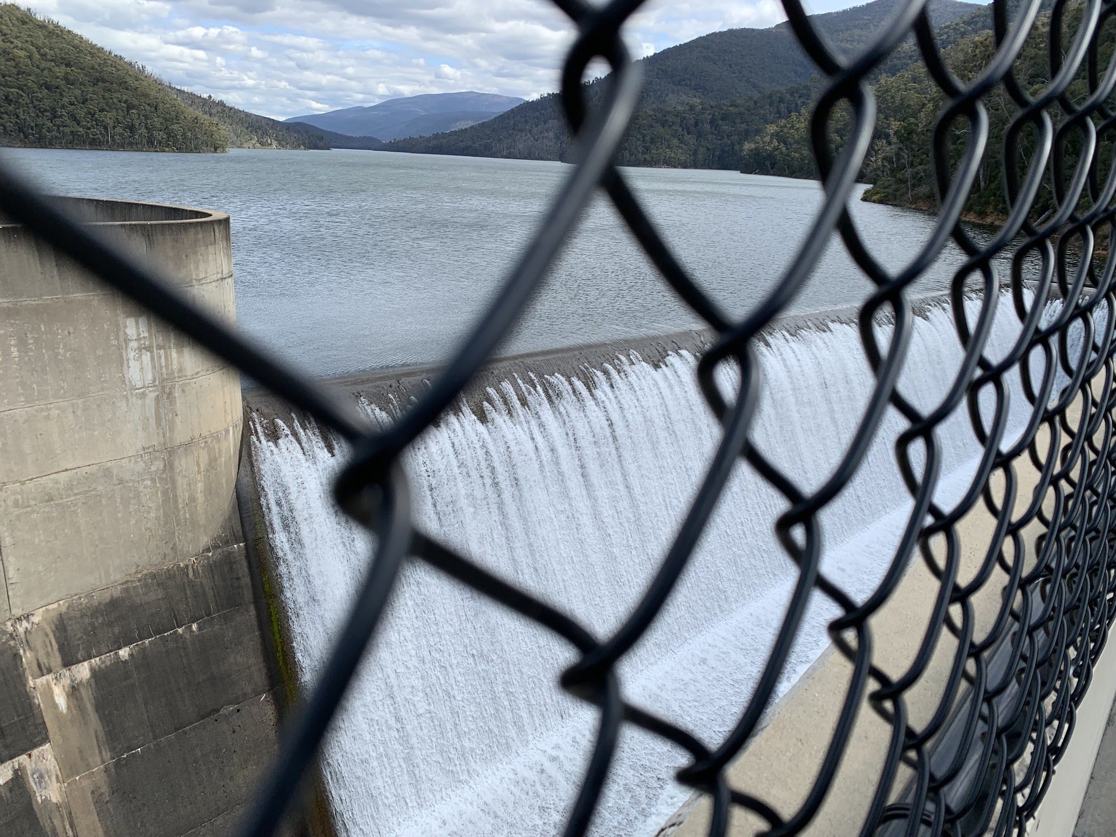
Corin Dam overflowing
Lots of surveyors and gear about. Thank goodness no government mobile phone camera as I drove out. I guess checking that Corin Dam is not going to collapse!

Surveying Corin Dam
Track Maps
Here’s where we went.

Track overview Little Ginini Mountain and Pryors Hut

Track 1 Little Ginini Mountain and Pryors Hut

Track 2 Little Ginini Mountain and Pryors Hut

Track 3 Little Ginini Mountain and Pryors Hut
Party
8 walkers. Phillip (leader), Jan and Philip, Jo, Leigh, Lorraine, Stephen, me.
Information Bit(e)s
I’ve had a lot of assistance from walking friends recently. By way of paying a bit back, I’ll publish a few bites of information that may help someone. Today’s is ‘4 The best free guide to Map Reading‘.
Maurice. Morrie Donovan
20 October , 2022 9:20 amHi John. Great report. I’ve camped at Priors Hut 3 times in Autumn and Spring a wonderful area.
Now you’ve given me something else to do up there..when I recover from a hip replacement just done. But you are still giving the bush and Mother Nature your best shot.
Well done and thanks Morrie
You
Johnny Boy
20 October , 2022 9:32 amYuma Morrie. All the best for a speedy recovery and back to wandering around. Yes, nice country between Ginini and Gingera. Yarra. john
Beat Oppikofer
20 October , 2022 10:24 ami did walk exactly same loop on 17th January 2021 (Solo Hiking)
Minz
20 October , 2022 1:01 pmFirst time I headed up that way, in the late 90s, we slept at the helipad after a late (post-uni) start, then encountered heavy snow; Pryor’s hut was full of hikers camping in the hut given how much it was snowing! We slept in the snow, on top of a mountain without tracks (not sure which). The things you do when you’re young…
Johnny Boy
20 October , 2022 1:20 pmYuma Minz. Thanks for sharing. It’s a magic place in the snow. You probably slept on nearby Mt Gingera, a km or so to the south of Pryors Hut. Agree … the things we did when we were young. Yarra, john