
At last we got across the Orroral River
Saturday 17 June 2023: Orroral Valley recce ! – L/M,W. Up the middle, return true left side of Orroral River.
Summary
From Garmin Connect (MAP66i) – Distance: 21.74km | Climb: 400vm | Time: 5:12 moving + 1:39 of stops = 6:51 | Grading: L/M,W; M(11).
Photographs Photographs are available here. Heaps of them, many not embedded in trip report.
gpx File The gpx file is available here.
Track Notes
I was last in the lower part of the valley (north of the tracking station) on 18 May 19 and did this loop on 3 Jun 14.
This old fella had an excellent day today! Several objectives achieved. 1. A recce for one or two upcoming Wednesday Walks I am to put on – now I won’t make such a fool of myself. 2. Found a crossing point over the Orroral River. 3. Visits to some old sites – a bit of nostalgia. 4. This one was not so successful – trying to show younger walkers some sites before I die, but I’m not sure of the level of interest ;-). 5. But my companions did learn what a Spot Height is!
A glorious blue-sky day, breezy and cool. Perfect walking weather. Wonderful company with unceasing chatter (between themselves), perfect for introverted me. Huge views to the tops on both sides of the valley and beyond.
Walking by 8.15am from the Orroral Valley Tracking Station site car park. There is some excellent historical information, including photos, about the Tracking Station here.
Pretty cold till the sun got over the north-eastern Ridge of Stone. Grand tors on the opposite ridge.

Haggis Rocks (from ACT Granite rock climbers’ book) on Granite Tors ridge
We passed the weather station. At the Link Track we turned left up to Cotter Hut Road, tromped it for a bit, then turned right at the next intersection. The reason for this was to visit the Winston-Gregson OR13 Stockyard site. Just about all reclaimed by nature, just a couple of posts remaining. On a previous trip on 15 Sep 09 we’d found old tins and bottles.

Nothing identifiable except a post or two at the W-G OR13 Stockyard site
The track took us down to Rowleys Orroral Valley Hut site.

Rowleys Orroral Hut site
A bit further on was another nature reclaimed hut foundation. Still visible on 23 Jun 09, now only a star picket is left (but we found some evidence on the next trip on 28 Jun 23. This is Patrick McLaughlin’s Hut site.

OR14 – 438 – Hut site
A little further on we found ourselves on the Orroral Valley Circuit track, which we followed all the way up the valley to Smokers Trail (where it turns left and goes on to join the Cotter Hut Road).

Orroral Valley Circuit signpost
Easy walking.

Walking the Orroral Valley Circuit
We left the track to visit Fishloch Yards.

Fishloch Yards
The photo shows SH1339 behind, a popular destination for walks. So began the Spot Height lesson.
We next headed down to the Orroral River. No crossing point here.

Check Orroral River Crossing 1
Back on the track, we followed its arc to the NW. SH1339 was a constant companion in this northern part of the valley.

SH1339 towered over us for most of the northern Orroral Valley
Approaching Sawpit Creek we first had some stepping stones.

Stepping stones
Closing in, I was expecting the bridge. It was there the last time I crossed it, on 30 Jul 16. Alas, gone.

Bridge over Sawpit Creek 3 June 2014
To this point, a few boggy bits of track. Here, our first wet feet for the day.

Crossing Sawpit Creek
At the junction of Orroral Valley Circuit and Smokers Trail, we turned right. Paralleled Sawpit Creek for a while with its expansive reed beds.

SH1339 over the reed beds of Sawpit Creek
Then north and down towards the northern Orroral River crossing. Some little shrubs beside a lovely Banksia gave us shelter from the breeze for smoko.

Morning tea Banksia
The Orroral River ford was dry and unexciting.

Orroral river culvert crossing
We immediately turned right into a scrubby start to a leg paralleling the Orroral River on the true left side, but it soon became easier going.

A little scrubby between the Orroral River culvert and Booroomba Creek
The going opened right up as we approached Booroomba Creek. I was fooled into thinking we’d get across with dry feet.

Fooled by the dry true right side of Booroomba Creek
SH 1339 continued to dominate.

SH1339 over the northern Orroral Valley
But, of course, the creek was across the open dry approach and over under the start of the incline up to the northern end of the Ridge of Stone.

Crossing Booroomba Creek
There are 2 boulders marked as red asterisks on the Corin Dam 1:25000 topo map.

SH1339 over the northern map-marked boulder

Southern map-marked boulder
Views west to ‘Dutchies Peak’.

‘Dutchies Peak’ over the Orroral River reed beds
Dutchies Peak (UTM 55H 670009-6060840) – “I was accompanied by six or so Club members and a foreign visitor to our shores, a delightful young Dutch woman whose first name was Antja. Antja (a keen bushwalker from the Netherlands) made a very strong favourable impression on all of us. l originally toyed with the idea of naming the peak Mt Antja, but it didn’t sound quite right to me. “Dutchies Peak” seemed much more poetic and appropriate and doubtless that would have been the name that I would have ascribed to it in my trip report for the Club Newsletter.” Source: Frank Bergersen email 29/3/19.
More boggy patches as we crossed a few drainage lines running down from the Ridge of Stone.
Great open views.
Just before lunch we found someone’s home.

Someone lives here
Lunch was called at 12.25pm.
After eating we went down to the river to check out an open run between the reed beds. No joy for crossing.
Around 1km further south we again checked the river for a crossing point. Great to see the water clear and much vegetation thriving in the fast flowing water.

Fast and clear flowing Orroral River at ‘Check Orroral River crossing 3’
Continuing downstream we at last found a crossing point, albeit with wet feet again. It was just by the Winston-Gregson OR 12 old footbridge site:
“Re-used plywood on old battens; two tree trunks; the whole nailed and wired togetherthen wired to neighbouring rocks. [in 1978] Poor condition, presumably built to enable sheep to graze both banks of Orroral River.”

Image from Winston-Gregson 1978 Thesis – OR11, OR12, OR13
OR11 – Rowleys Orroral Valley Hut, OR12 – The footbridge, OR13 – Stockyard site
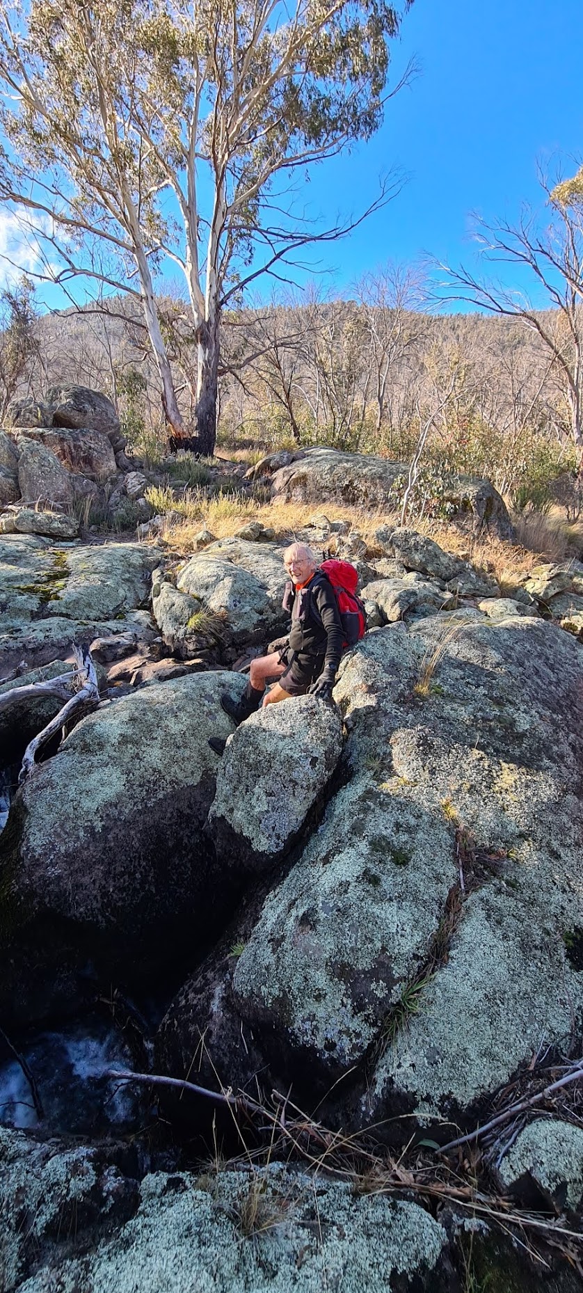
At last we got across
A couple of hundred metres downstream was a small, but noisy, cascade.

Little cascade on the Orroral River
It would be possible to cross here with dry feet and I have in the past.
Sitting at another crossing point below the cascade on the Orroral River | photo Shannon
A little further south, another possible crossing point.

Can cross Orroral River here – steep bank on true left side
Nearly all over bar the shouting now. We regained the Orroral Valley Circuit, crossed the boardwalk over James Creek and came to the Link Track at 2.18pm. There was a last place my companions had not visited, so we headed NE on the Link Track to cross the Orroral River bridge. I was gallantly walking through the puddle so as not to widen the route, when my companions passed me via the trodden down reeds. I joined them.

Skirting the puddle at the Orroral River bridge
We wandered up to the boulder.

Approaching the boulder beside the Link Track
This is another Winston-Gregson identified site which he classified as an indigenous shelter.
We squeezed through the internal slots, a bit like a mini Split Rock.

Inside the boulder
Back over the bridge we turned south to a ‘concrete thing’. Anyone know what it was for?

‘Concrete thing’ – what is it?
Back through the laser sites.

Laser site remains
Excellent day. These ladies can certainly walk and talk!
Relive the trip
Track Map
Here’s where we went.

Track Orroral Valley recce
The AllTrails map is here, where you can pan and zoom.
Party
4 walkers – Shannon, Ming L, Sandra T, me.
Johnny Boy’s Walkabout Blog FaceBook Page
I’ve started up a FaceBook page. Each trip report posts to it. So it’s another way to get some info to get out and breathe a bit of fresh air. Why not pop over and Follow the page, or give a post a Like.