
Top end of track on 1st edn Rendezvous Creek 1:25000 topo map
Monday 12 June 2023: Walk 1 – From the Orroral Tracking Station track-head, walk the Granite Tors Walking Track to the Geodetic Observatory. Do a loop of the magnificent tors via the GTWT extension. To add a bit of fun, return off-track directly down to the start, trying to find a very old track alignment from the old 1st edition Rendezvous Creek 1:25000 map. This would be a steep 350vm descent over 2km. Walk 2 – From the Nursery Swamp car park, just back down the Orroral Road, walk the Nursery Swamp Walking track to the fen, the largest sedge peat deposit in the ACT. Return the same way.
Summary
Walk 1 – From Garmin Connect (Epix Gen 2) – Distance: 9.15km | Climb: 470vm | Time: 3:50 including morning tea.
Walk 2 – From Garmin Connect (Epix Gen 2) – Distance: 9.07km | Climb: 310vm | Time: 2:40.
Total – Distance: 18.22km | Climb: 780vm | Grading: L/E,R; H(12).
Photographs Photographs are available here.
gpx File The gpx file is available here.
Track Notes
I was last at the Geodetic Observatory and on the Granite Tors Walking Track on the ridge on 17 Aug 19. Did a direct descent near today’s route on 26 Jan 16.
-5°C for the start from the Orroral Valley Tracking Station today. An overcast day with only a short burst of sunshine around 1pm. Cool.
We headed up the Granite Tors Walking Track, looking little different from nearly 4 years ago.

Granite Tors Walking Track at 1150m contour
Looking down into the valley, I was fooled by the heavy frost.

Orroral Valley – I thought it was fog, but it was frost
Turning the corner and paralleling the ridge, we could hear plenty of water running in James Creek. We arrived at the Geodetic Observatory at 9.25am, doing the 4.1km in 1:12 and climbing around 400vm.

Geodetic Observatory
We had a look through the building and a look down from the nearby NMC 106 point. We could see down to the Orroral Tracking Station site and the tanks we were to descend to later.

Car park, old tanks and Orroral Tor from NMC 106 beside the Observatory
We next did a lap of the beautiful ridge. Great track, fabulous tors. Heaps more photos.

Features on the Granite Tors Walking Track extension on the ridge

Granite Tors Walking Track extension

Features on the Granite Tors Walking Track extension on the ridge
We popped out on the old vehicle track and went back up to NMC 106 beside the observatory for morning tea.
The purpose of the direct descent was to see if anything could be found of an old track alignment. I was hoping for at least a gap in any mature trees.
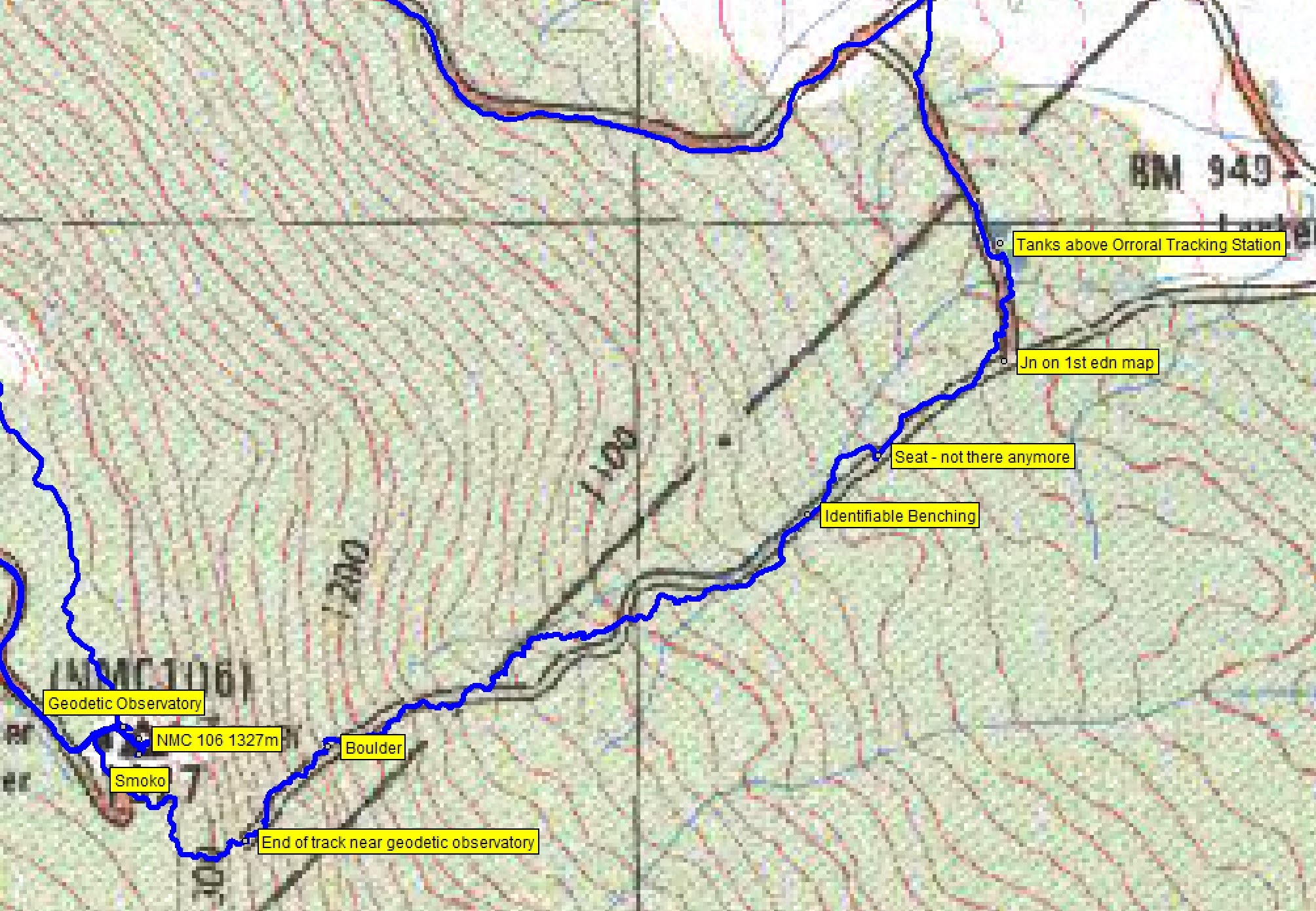
Old road alignment on 1st edn Rendezvous Creek map
With the top of the track in my GPSr, we got to the point at 10:39am. Not a sign of an old road alignment in sight, not until we were most of the way down. I tried to follow the alignment but gave up around the 1150m contour. The top section was reasonable going amongst larger tors. Then a couple of patches of more open going as drainage lines developed. But as the creeks formed and deepened, there was a bit of dense scrub so the hunt was abandoned and we headed down a vague spur. As you can see from the map segment above, we hit the alignment a couple of times. But nothing was identifiable until the 1050m contour, where we could discern some benching.

Recognisable benching
The going opened up and we reached the old tanks seen from above.

Tanks above Orroral Tracking Station
An old vehicle track took us N to join the Granite Tors Walking Track and so back down to the car park. The descent from the top was 2.5km across the ground in 1:22, dropping 360vm.
Apologies to any walker who was expecting a terrain = E trip. The terrain = R for the descent was sort of hidden in the Bilby Terrain Information.
Lunch in the shelter shed. We got a bit cold sitting around so the 30 minutes was cut a bit short.
Drove to the Nursery Swamp car park.
Set off up the Nursery Swamp Walking Track at 12.30pm. Still looks the same.

Nursery Swamp Walking Track at 1100m
A couple of short bits of track re-alignment and bits of meshed walkway.
We walked to the end of track signage, 4.5km in 1:20.

Signage at marked end of Nursery Swamp Walking Track

Nursery Swamp
The boardwalks have not been burnt. One old section.

Old boardwalk
Both the Orroral Tracking Station car park and the Nursery Swamp car park chockers with cars. Great to see so many people out in the Namadgi again.
Excellent party, plenty of chatter. Lam, the walking machine, on her third trip for the long weekend.
Track Maps
Here’s where we went.
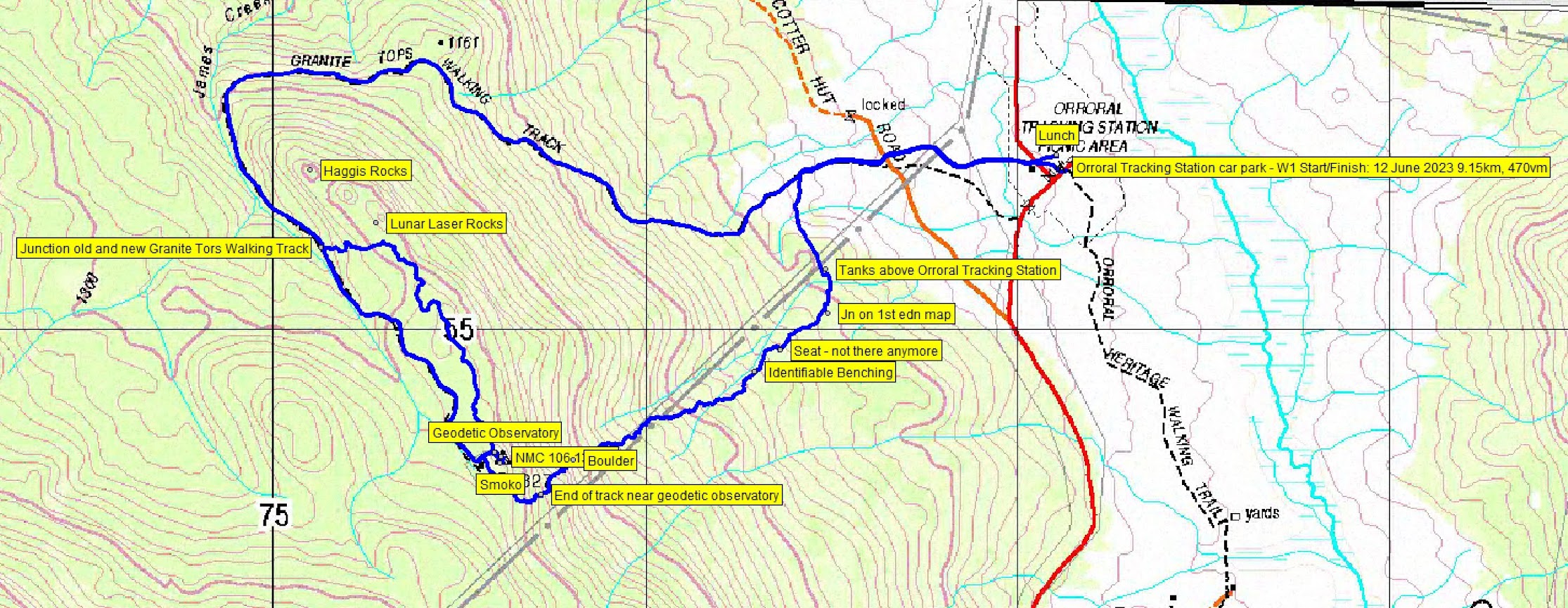
Granite Tors Walking Track

Nursery Swamp
The AllTrails maps are here and here, where you can pan and zoom.
Party
12 walkers – Jenny A, Andrea C, Shannon H, Kirk H, Anna H, Ming L, Deb M, Quentin M, Rivera M, Sal O, Lam S, me.
Johnny Boy’s Walkabout Blog FaceBook Page
I’ve started up a FaceBook page. Each trip report posts to it. So it’s another way to get some info to get out and breathe a bit of fresh air. Why not pop over and Follow the page, or give a post a Like.