
View from the side of Hindmarsh Drive to Parliament House
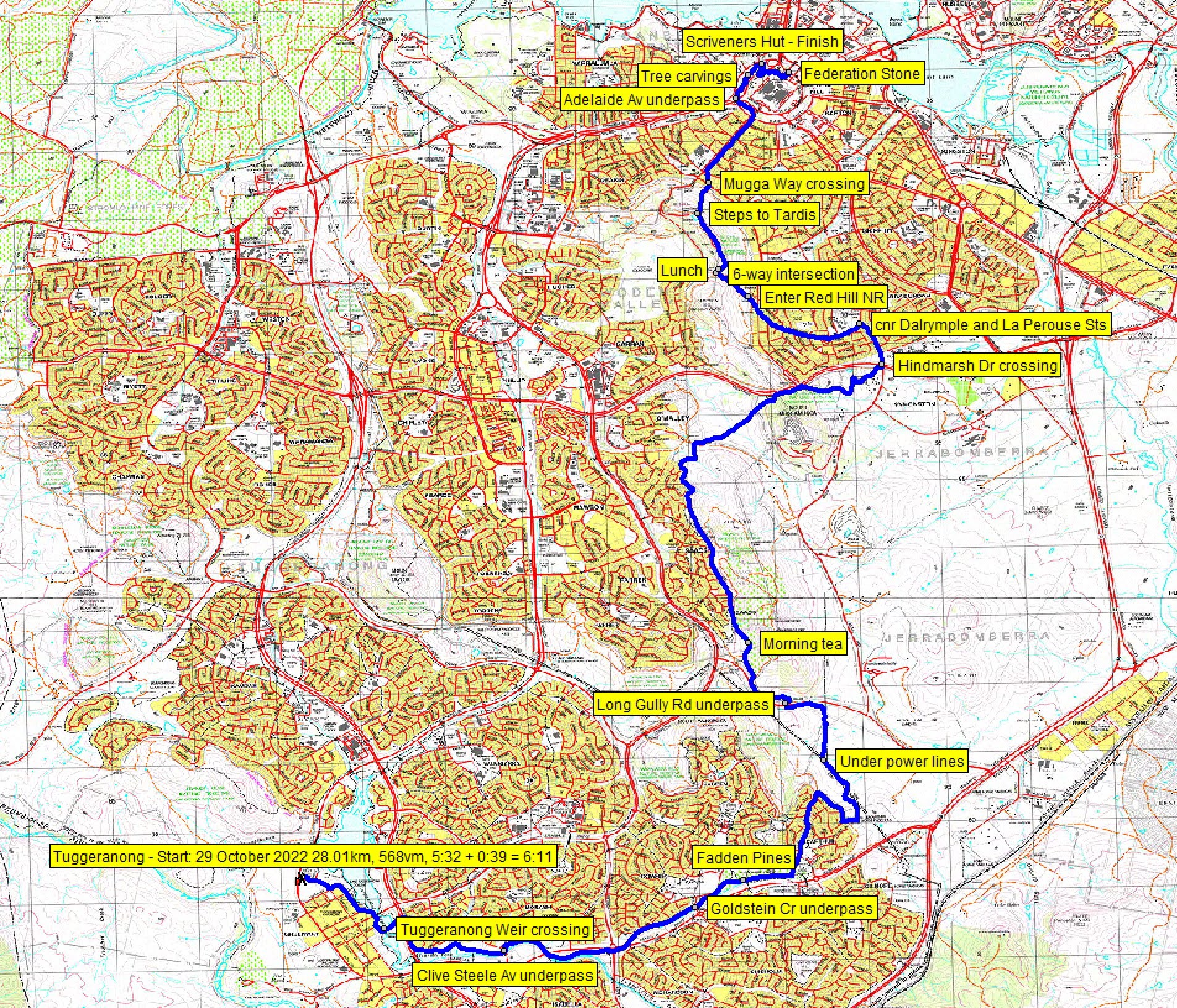
Saturday 29 October 2022: Canberra Centenary Trail – Section 7 – Tuggeranong to Parliament House * – L/E,ptX. Highlights include Fadden Pines, Isaacs Ridge, Mt Mugga Mugga and Red Hill Nature Reserves. Lowlights include quite a bit of urban walking through Tuggeranong suburbs, Red Hill and along Melbourne Avenue. But it has to be done if you want to walk the CCT. Around 28km and 600vm climb. Limit 12. Early morning assistance required from one (or more, depending on number of walkers) driver/s to set up car shuttle, prior to start of walk.
Summary
From Garmin Connect – Distance: 28.01km | Climb: 568m | Time: 5:32 moving + 0:39 of stops = 6:11 | Grading: L/E;ptX; M(11).
Photographs Photographs are available here.
gpx File The gpx file is available here.
Track Notes
I was last on this section of the Canberra Centenary Trail on 18 Aug 12.
I sold a bit of a pup to my companions today. No Isaacs Ridge top, no boiler on Mt Mugga Mugga. But they hadn’t been on this route before so were happy. You have to try something once.
We put the car shuttle in place and were walking at 7.56am. Only trouble was that the Tuggeranong Park Run had attracted a few hundred participants! So we walked a few Tuggeranong streets. Had to join the Park Run at the edge of Lake Tuggeranong – between the fast runners and the slower walkers. We left them after crossing the Tuggeranong weir.
Nothing but hard shared path (bike path) beside a concreted Tuggeranong Creek to Fadden Pines.
Turned north here and up a greenway through MacArthur. Crossed Jackie Howe Crescent and into open space.
But there’s a CCT detour in place here, which takes the route SE. I’m positive there was no further detour signage, so our detour loop was a bit longer. We finally got back on the CCT after traversing the MacArthur Horse Paddocks.

Kangaroos on the west side of the MacArthur Horse Paddocks
Under the power lines, into the Rose Cottage Horse Paddocks, walked north to near Long Gully Road, through an underpass and into the Isaacs Ridge Nature Reserve.
A stop for morning tea on the side of the management trail.
In several areas at high points, the Canberra Centenary Trail divides. There’s a lower, flatter route for bike riders and a higher, climbing route to hill tops for walkers. However, the higher route branching up in Isaacs Pines was closed, so we missed the opportunity to walk the ridge top through YA90 trig.
NE from the northern extent of Isaacs Ridge NR and into the Mt Mugga Mugga Nature Reserve. I was beginning to flag, so told my companions that we wouldn’t see the boiler atop the old quarry which featured in the walk description photo.
The CCT route parallels Hindmarch Drive for a while.

View from the side of Hindmarsh Drive over to Parliament House
It waggles down to the Hindmarch Drive – Mugga Lane/Dalrymple St intersection, where we crossed at the lights.
Street walking through the suburb of Red Hill, at last crossing Mugga Way and entering the Red Hill Nature Reserve.
Up to the Red Hill saddle and lunch at the seat nearby. A bit cool in the breeze.
Setting off again, we climbed to the Red Hill area. Advertising seems to imply that the restaurant is open again. Along Red Hill Drive and down the steps to the Tardis. On down the stepped route to cross Mugga Way and winkle to the top of Melbourne Avenue.
Although street side walking, it’s quite pleasant though this old money area. Some historical items.

Old fire hydrant, bus shelter and street sign post on Melbourne Avenue
Across State Circle, under Adelaide Avenue. Walked across the Capital Circle to State Circle fly-off.
The CCT then enters a beaut bit of remnant woodland between State and Capital Circles. If it wasn’t for the noise of vehicles, you could be out in the bush. Lovely.

Remnant Woodland between State and Capital Circles
A surprise for all of us, some nice tree carvings.

Tree carvings in remnant Woodland between State and Capital Circles
The route comes out very near Surveyors Hut. We passed within metres of Jenny’s car. But with a pedant leading, we had to get to the Federation Stone. So it was up through the Parliament House gardens, not previously seen by my companions. Manicured. Quite a contrast to the bit of natural bush we’d walked.

Manicured gardens V Remnant Woodland, 200m apart
I insisted we circle the Federation Stone. Some protesters about. Returned down to the Surveyors Hut car park. All over. Third CCT section ticked off.
The ladies walked me into the ground. From Garmin Connect, our average moving speed was 5.1km/h and avg speed (which includes breaks in the time) was 4.9km/h. I was a bit tired, but home early for extra brownie points to cash in to walk tomorrow morning.
Relive the Trip
Track Maps
Here’s where we went. Topoview 2006 maps, so a few roads/suburbs might be missing.
Track overview CCT 7

Track 1 CCT 7

Track 2 CCT 7

Track 3 CCT 7

Track 4 CCT 7

Track 5 CCT 7
The AllTrails map is here, where you can pan and zoom.
Party
3 walkers. Jenny A, Ming L, me.
Matt Brown
30 October , 2022 5:12 pmHi JB – Love your blog! I’m planning N-S through hike of AAWT in March. Wondering if you know of anyone interested in joining me? Matt
Johnny Boy
30 October , 2022 5:29 pmYuma Matt. Thanks for your kind endorsement. I follow a couple of Facebook local groups, A.C.T Hikers, ANU Mountaineering Club (ANUMC) and Hiking in Canberra. Maybe a request for company in those might get a response. I think they’re private groups, so you’d have to join them first. Have a great AAWT trip! Hopefully the rain will have eased by next March. Yarra. john
Terrylea Reynolds
30 October , 2022 9:03 pmGo Jenny and Ming! What a chuckle.
Johnny Boy
30 October , 2022 9:28 pmIndeed. They are quick and strong walkers.