
Returning from the top lookout
Sunday morning 30 October 2022: Sunday morning at Gibraltar Peak. A circular loop starting and ending at the Tidbinbilla Visitor Centre. No entry fee to Tidbinbilla required when you park at the Visitor Centre. This is a moderate walk with splendid views of Canberra. The walk itself is a mix of single track and rocky trail, well formed. No bush bashing today! Start at 8am and be home for lunch! Just take a mid-morning snack to enjoy at the top.
Summary
From Garmin Connect – Distance: 13.69km | Climb: 512m | Time: 3:22 moving + 1:00 of stops = 4:22 | Grading: M/E; M(8).
Photographs Photographs are available here.
gpx File The gpx file is available here.
Track Notes
I was last at Gibraltar Peak on 26 May 18.
Today Noelia led her first CBC trip. She did a huge job, with just about every conceivable issue thrown at her. And she’s no beginner. She’s already put her hand up to lead the 2022 Worn Boot Bash, reviving a CBC tradition after nearly three years without it.
We set off along the Congwarra Trail, a track I haven’t walked before. It leaves the Tidbinbilla Visitors Centre at the car park and parallels Tidbinbilla Road on the south side. A bit muddy in places with all the rain we’re experiencing. But it was a beautiful nearly blue-sky Spring day. It crosses Tidbinbilla Road and goes down through the Nature Discovery Playground, then off the west side of Tidbinbilla Road to the Turkey Hill parking area (my old digital maps show this as Education Centre, which was burnt down in the 2003 firestorms).
We crossed Tidbinbilla Road again, to the east side and followed our noses – well, the track signs. Veer left, don’t go up to the Grass Trees. Nice to chat with old and new friends. You can see the wiggles on the track below, where the track design kindly zigzags to relieve the vertical climb. We popped out on the Eliza Saddle where there is a nicely constructed natural bench.
The story of John (s Peak) and (Mt) Eliza is told on signage on the Church Rock Heritage Walk. “Johns Peak 1453m Named after John McDonald husband of Eliza Webb”. So husband and wife eternally gaze at each other across the valley they once farmed.
There’s a helping hand on the next section of the walk.

Handrail to heaven
Dogwood (Pomaderris) lines the upper section of the track and it’s just coming into flower.

Dogwood beside the track
A surprise for one party member, who’d not been up this way, was the lookout. Grand views to the Tidbinbilla Range and the green paddocks of Tidbinbilla Station over the other side of Paddys River Road.

View from the lookout
The track arrives at the bottom of the final ascent. Signage asks visitors to respect the cultural importance of the Peak.
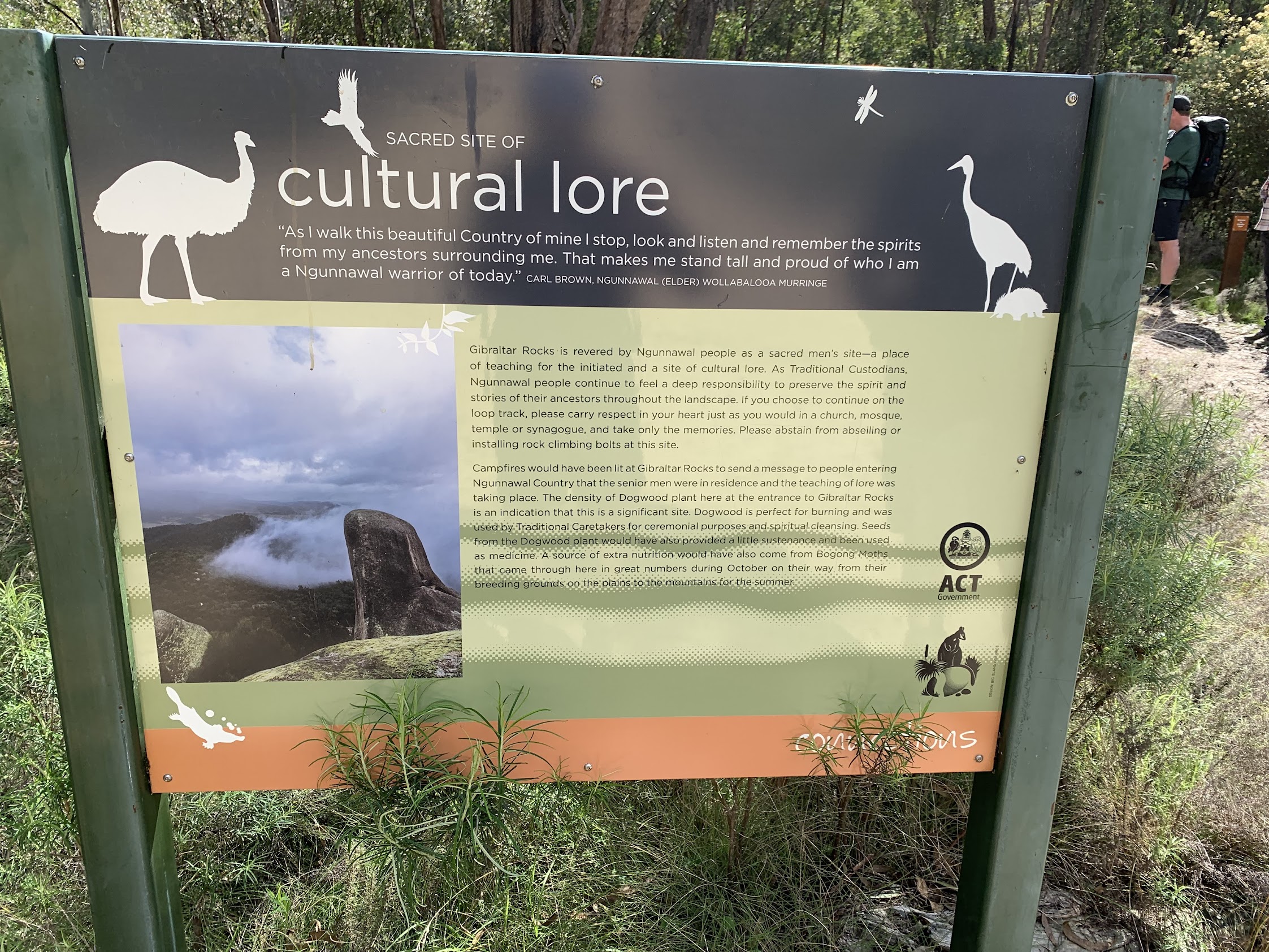
Signage below the final ascent
A puff up the stone steps, the track now well-defined to the top lookout with its SE view.

View from the top lookout SE over Corin Road
Turning around to leave, one can admire the marvellous granite tors.

Returning from the top lookout
We enjoyed morning tea at the usual place, with its view out to the main gigantic tor.

Typical view from Gibraltar Peak to Mt Eliza
Down the stone steps and back on the descent trail, there was a little whoopsie, but no nose or teeth broken, so all good-ish.
At the Eliza Saddle, we took the easterly trail which heads down towards Birrigai. Some lovely grass trees beside the lower part of the track. Aware of Bunnings prices for said legal items, I salivated at the (illegal to remove them) near priceless specimens we passed.
We doubled back a bit to visit the Birrigai rock shelter.

Birrigai Rock Shelter
Signage at the site tells of scientific excavation of items dating back at least 21,000 years.
Finally down onto the more open areas of the Birrigai Time Trail and past the SODAR (Sonic Detection and Ranging) site. There’s another one down in the Rendezvous Creek valley with a geocache nearby. The cache owner kindly provides the description “It emits sounds into the atmosphere to measure wind speed and direction at different altitudes up to 900 metres above the ground. Once transmitted, a fraction of the sound bounces back into the equipment. The strength of this returned signal provides information about the turbulence and temperature of the atmosphere above.“
Back to our vehicles and a very well done to our walk leader.
Track Maps
Here’s where we went. On Topoview2006 map.

Track Gibraltar Peak
The AllTrails map is here, where you can pan and zoom.
Party
7 walkers. Gerald D, Pat M, Noelia P (leader), Lachlan Q, Phillip S, Sandra T, me.
Noelia
30 October , 2022 8:45 pmThanks John. Such a beautiful morning we had!
Johnny Boy
30 October , 2022 9:22 pmIndeed we did. So very well led!