Scabby Range, Mts Kelly, Burbidge, Namadgi (behind tree) from Yankee Hat North

Tuesday 9 December: Yankee Hat North and Middle Creek – M/R,ptX. Yankee Hat rock art, up Yankee Hat North for geocache GC33R07 Oh My Hat!. Saddle, then down NW and up Middle Creek a way to geocache GC26Y22 Dinner Rock. Return true left Middle Creek and Gudgenby grasslands. Around 15km and 600m climb. Maps: Rendezvous Creek and Yaouk. Leader: John Evans 0417 436 877 john@johnevans.id.au . Transport: $12.
6 of us drove in 2 cars to the Yankee Hat car park.
Further Information
Look for geocaches GC33R07 Oh My Hat! and GC26Y22 Dinner Rock.
Summary
Distance: 15.0km | Climb: 580m | Time: 8.00am-3.50pm (7hrs 50mins), with 50 mins of breaks | Grading: L/R,ptX; H(12)
Track Maps
Track overview

Track 1

Track 2
Photographs
Photographs are available, where you can start a large sized slide show.
gpx File
Download the .gpx file here. (Right click, Save Link As…, Save – if you want to use it.)
Track Notes
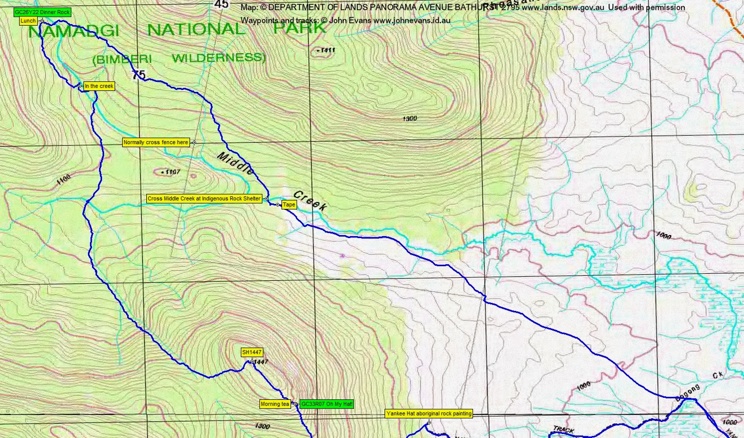
A 3.0km 38min stroll to the Yankee Hat indigenous rock art.
From there, we headed SW and up towards the crest of the SE spur from Yankee Hat North. Easy going at first, but the regrowth soon closed in. Some tough and slow going, particularly as we climbed up the crest of the spur. At last we reached the geocache and threw ourselves down for morning tea. 1.4km in 1hr 30mins. We were damp from perspiration as the morning was quite warm, the breeze minimal and the 330m climb exhausting. But a quick find of the cache by Lorraine and the lovely view down to Middle Creek and the grasslands below revived us.
We continued up and on across the top to SH1447, Yankee Hat North. A few granite tors here. (Don’t know why the GPSr tracking skipped a beat – probably like my heart.) A lyrebird nest and lovely views down to the East. From the SH, great views NW to the Scabby Range, Mt Kelly, Mt Burbidge and Mt Namadgi.
The South-West facing flank of the hill is always a little less overgrown and it proved so again today. The descent to near the saddle between Yankee Hat North and Yankee Hat South was more pleasant.
I originally planned to descend one of the NW spurs coming down off SH1447, but I got in the top of the drainage line and found it relatively easy going. We crossed the southern arm of Middle Creek at 12.15pm and picked up some water. From morning tea to here was 2.5km in 1hr 50mins.
1.7km in 1hr saw us above the main arm of Middle Creek at the next geocache site. A couple of patches of relatively open going across the bottom of the Burbidge spur, a little tighter down near the creek, an enjoyable and cooling wade for a hundred metres or so in the creek (quite manageable and with few log jambs), then out and in high from above.
Not sure where the cache owner was coming from/going to when a stop was made at ‘Dinner Rock’, but today’s party was unimpressed. Not much of a view and not much shade. But each to his own, hey Jmanjezza. My wonderful companions spent some time searching with me, but no joy. Whilst they lunched I continued to look and searched in quite a large radius. About to give up in a branchy, leafy, debris-filled slot of walkable width, turned around and there it was, well como-ed in a painted container. Made my day. Just time to stuff down one sandwich and we had to leave.
Away at 1.45pm. Headed off to the East and down to cross Middle Creek. A huge log for Eric; I crossed at the top of a cascade. Now in familiar territory,but I went higher than both my out and back legs of last month’s birthday drinks on Mt Namadgi on 8 Nov 14. Crossed the fence line 300m uphill from the usual spot. Still, no big deal and a relatively painless leg back to the Middle Creek rock shelter. From lunch to here 2.2km in 1hr.
One wet step across Middle Creek and onto the end of the old vehicle track. Then across the grasslands, over the boardwalk and Bogong Creek bridge and back to the cars. The leg 4.2km in 1hr 5mins.
We stopped at the Tharwa General Store on the way home to undo all our good work of the day.
Thanks folks. Most grateful to you for enduring yet another caching walk.
Party
6 walkers – Cynthia C, Eric G, Phillip S, Lorraine T, Ian W, me.
Next Tuesday Walk
Tuesday 16 December: Tallaganda National Park- L/R Part X. The start is 12 km south of Captains Flat on the Wild Cattle Flat road. We will spend the day off-track in the forests of Tallaganda National Park. We will investigate a rocky bluff at GR 219429, that was visited on 26/8/2014 in wet weather. The day’s route will differ from the previous walk. Distance: 15 km with 500 metres of ascent. Map: Tinderry. Leader: Ian W. Limit: 8. Transport: 155km return.