Tight going near SH1402

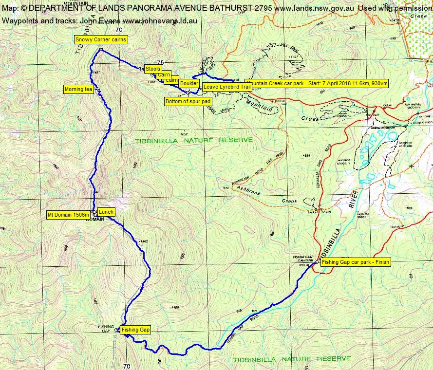
Saturday 7 April: TNR Skyline Track south – L/R. The Tidbinbilla Range crest divides into two walks and today we’ll do the southern section. Walk the Lyrebird Trail from Mountain Creek car park, climb 500vm to the Snowy Corner cairns, then south along the crest to Mt Domain and so down to Fishing Gap and Fishing Gap car park. Awesome views and some thick scrub. A short car shuttle. Around 12km and 950m climb. Participants should not object to route marking using tape (approved by TNR management). TNR open 7.30am-6pm. Sun shining 6.20am-5.50pm. Map: Tidbinbilla. Leaders: John Evans and Rob Horsfield. Transport: ∼$15/person (2 cars needed). Limit: 8.
Further Information
This trip is not for all. Some of my walking companions object to taping routes; my opinion is that the rugged joys of this area should be opened up to more walkers. In addition, even though the route from Snowy Corner to Mt Domain is now taped, it is still a long and hard walk and timing needs to be such that you are out of TNR by gate closing time (6pm EDT, 8pm EDST). It is also not an area I’d like to be in in adverse weather conditions.
The taping was done with the agreement of the land manager and is in harmony with the Tidbinbilla Nature Reserve Management Plan.
I was last here 17 Oct 17.
Summary
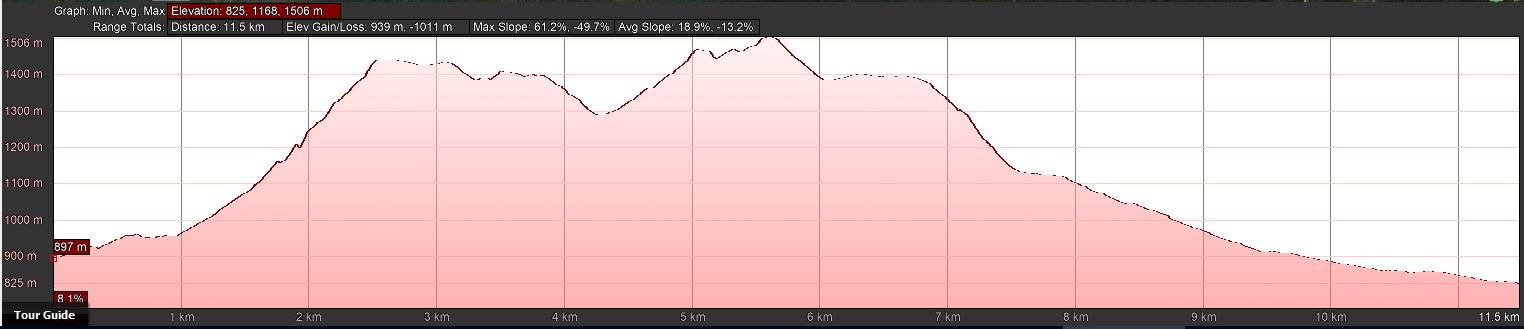
Distance: 11.6km | Climb: 930m | Time: 7.45am – 3.15pm (7hrs 30mins), including 35 mins of breaks | Grading: M/R; H(13)
Photographs
Photographs are available, where you can start a large sized slideshow.
Videos
Waypoint and Track Files
Download the trip .gpx file. (Right click, Save Link As…, Save – if you want to use it.)
To use in Google Earth, do File, Open… and select Gps or All files as the File Type.
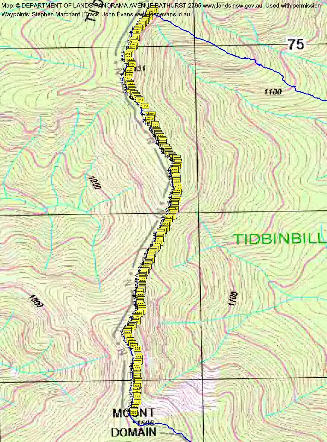
Download the tape positions .gpx file, thanks to Stephen Marchant. (Right click, Save Link As…, Save – if you want to use it.)
To use in Google Earth, do File, Open… and select Gps or All files as the File Type.
Track Notes
We were waiting for the TNR gates to open when the Ranger came through at 7.25am. Drove clockwise around the Tidbinbilla Ring Road and left one car at the Fishing Gap car park. We squeezed into the remaining vehicles and drove on to park at Mountain Creek car park.
Set off at 7.45am, up the link track, across the Camel Back Fire Trail, along the Cascades Track and left onto the Lyrebird Track. Lovely and cool on these shaded walks. Not much water flowing in Mountain Creek.
At the designated spot on the Lyrebird Track (where a noticeable footpad is developing), we sidled up to the crest of the little spur and turned a bit right onto the pre-2003 fires Lyrebird Track. A few tens of metres along it, we came to the bottom of the well developed footpad up to the Snowy Corner cairns. A little cairn is at the junction and the footpad is quite clear. It’s easy to follow – I only lost it once 😕 . The climb is steep and we took it at a reasonable pace, including a break at the stools. The leg from start to the Snowy Corner cairns was 2.6km in 1hr 25mins.
Whilst the tail caught up I had a scout about as to where we should exit to the south and hang the first tape. I certainly didn’t want to confuse any departure from here – you can go north to the map-marked Snowy Corner and Tidbinbilla Mountain, east back down the spur to civilisation, or south to Mt Domain. A theory was explained that first tapes should be hung, say, 50m from a point, so as not to cause confusion. Anyway, the first is well in sight. Just choose carefully, depending on your planned route – north or south, or east and down to exit the crest.
We worked very well as a team to complete the task and our walk, First came Rob, the master navigator. He had one look at his map and compass before we set off, then unerringly followed the best route along the crest, picking up sections of faint footpad and old tapes at times. Next came Phillip, the romper stomper – he brought considerable weight to bear on many a shrub to help to define the track. I had 4 * 100m rolls of orange surveyors tape with me, so I pulled off a length and looped it over a branch every now and then. Terrylea tied around 297 knots during the day! Others also stomped and attacked the regrowth. Jenny had some heavy duty snippers which did a great job. Stephen kindly brought up the rear and waypointed every one of those 297 tapes.
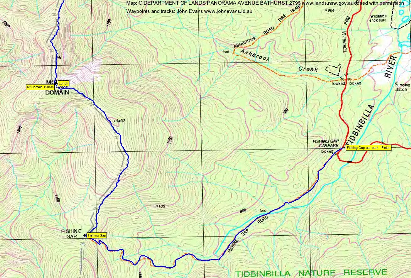
So that’s how we worked south along the crest. The pace was relatively easy, so we could do all those things. But, as I said, it is still not an easy walk – a big climb up to the crest, some undulations along the top (especially down into the saddle about half way to Mt Domain), a very scrubby climb back up towards Mt Domain and, when you think it’s all over, a long walk out along Fishing Gap Fire Trail.
We had morning tea 740m and 35mins south of the Snowy Corner cairns, on one of a couple of open, shale-y knolls.
The main leg, from morning tea to lunch, was 2.2km in 2hrs 25mins. Some tough going. The intermediate saddle, from which Cow Flat Creek tumbles down 450vm to the Cotter River in the west and Ashbrook Creek drains to the east, has some blackberry and stinging nettle. You can see this prominent saddle on the Tidbinbilla Range crest when looking west from many parts of Canberra.
We made the open spot 50m north of Mt Domain at 12.45pm and called lunch to admire the views.
One feels like it is all over bar the shouting here. But it is a long shout of 6km taking 2hrs 10mins, first from Mt Domain to Fishing Gap, then down the fire trail to the car park. Terrylea kindly and expertly led us home. There are still quite a few tapes about from my 16 Mar 16 hangings. And, once through the open area at the bottom of the descent from Mt Domain to the NW end of the SH1402 ridge, they are well needed. Check out the photo of the tight going above!
From the nose of the ridge at around the 1380m contour, where the footpad turns from SE to SW for the descent to Fishing Gap, the footpad widens. This is thanks to work contracted out by the land manager a couple of years ago. The descent is quite beautiful and the track condition allows you to lift your eyes and enjoy the view. But it is a bit steep and slippery in places and there are a few ‘toe tapping’ sapling trunks cut off just an inch or two above the ground. The last few hundred metres into Fishing Gap, where some complained that initial track clearing was over-zealous, is now soft, very attractive and enjoyable.
Beautiful extended Autumn weather. Great crew, great job, great trip. I do hope the route is walked in and enjoyed by other suitably capable parties.
Track Maps

Party
9 walkers – Julie H, Jenny H, Rob H (co-leader), Stephen M, Rowan P, Lisa Q, Terrylea R, Phillip S, me.