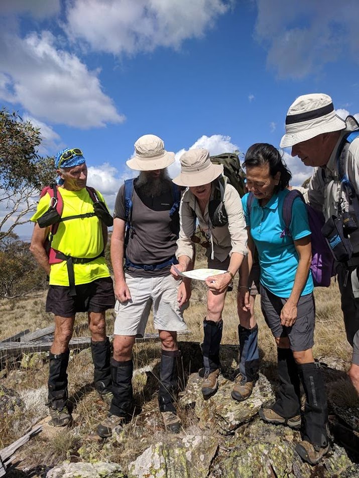
Where are we? – checking the map on SMA1149 | photo by Meredith H on Terrylea R’s phone
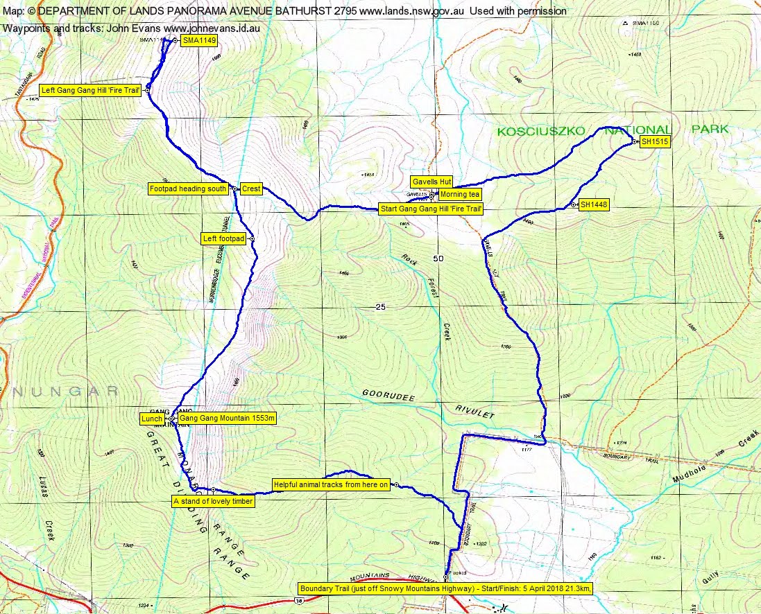
Thursday 5 April: Gavells Hut and Gang Gang Mountain – L/R,X. After an early start and a long drive our walk commences at the locked gate on Boundary Trail just off the Snowy Mountains Highway. Along Boundary Trail and Gavells Hut Trail to Gavells Hut then the rest of the day off track through unknown vegetation which may be very scrubby for the last few kilometres. Brilliant vistas if the weather permits. At various stages of the walk we may have views to Mt Nungar then across the plain to the ACT mountains, Mt Tantangara, Tabletop, Jagungal, Lake Eucumbene and Adaminaby. Total climb of 800 m. Distance 20+ km. For fit and reasonably quick walkers only. Leader: Phillip S.
Further Information
I’m pretty sure that Phillip was attracted to this area by a trip report by Brian Slee on page 17 of the NPA ACT Bulletin of June 2013. I’d been to Gavells Hut on 14 Jun 11.
Summary
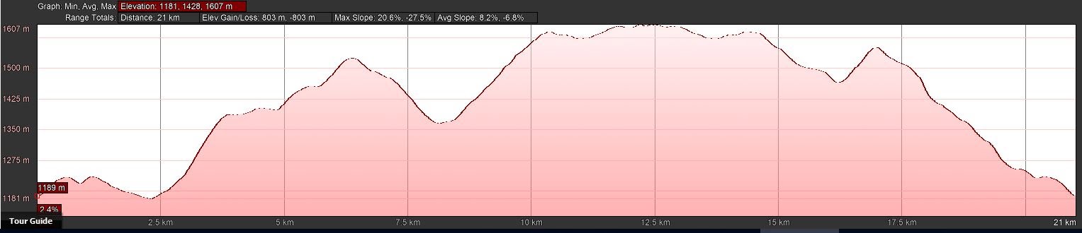
Distance: 21.3km | Climb: 800m | Time: 8.15am – 3.10pm (6hrs 55mins), including 50 mins of breaks | Grading: L/M; H(13)
Photographs
Photographs are available, where you can start a large sized slideshow.
Waypoint and Track Files
Download the .gpx file. (Right click, Save Link As…, Save – if you want to use it.)
To use in Google Earth, do File, Open… and select Gps or All files as the File Type.
Track Notes
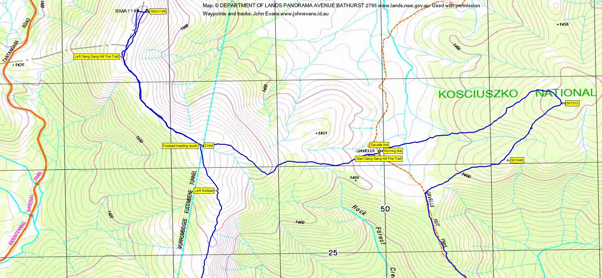
A 6am leave from Calwell. A doze in the back on the way made it a short trip through Cooma to Adaminaby, where we stopped for a quick coffee. Then on to where Boundary Trail crosses the Snowy Mountains Highway. There’s a sealed car park (chain fitting bay) on the left, but high clearance vehicles can drive in along Boundary Trail to the north for a hundred metres or so.
Walking by 8.15am north along Boundary Trail. We dispatched the 2.4km to the junction with Gavells Hut Trail in 30 minutes.
Here we turned north onto Gavells Hut Trail and walked it for 2.2km. We were within 800m of Gavells Hut, but Phillip had prepared a lovely off-track detour to the NE. We enjoyed a gentle climb through snow grass and snow gums up through SH1448 to SH1515. Nice relatively open woodland and forest. Treed spot heights, so not much view.
Turning west and SW we headed down towards the southern end of the open Nungar Plain and Gavells Hut. Phillip scared the life out of a peacefully sleeping snake as he stepped over it – and vice versa! Our 3.8km detour took 1hr 15mins.
Morning tea at Gavells Hut.
Now here’s something of interest to me. When doing my own little preparation for walks, I often look back at the older version of my NSW TopoView 2006 digital maps. I can sometimes pick up old vehicle tracks, no longer on current maps, which can assist route finding. This time I looked forward, accessing the NSW SIX site’s e-Topo facility for the Denison 1:25000 map, free PDF download. Zooming in, you find the Gang Gang Hill Firetrail leaving Gavells Hut and heading west and NW over the crest of the Monaro Range to join the Bicentennial National Trail:
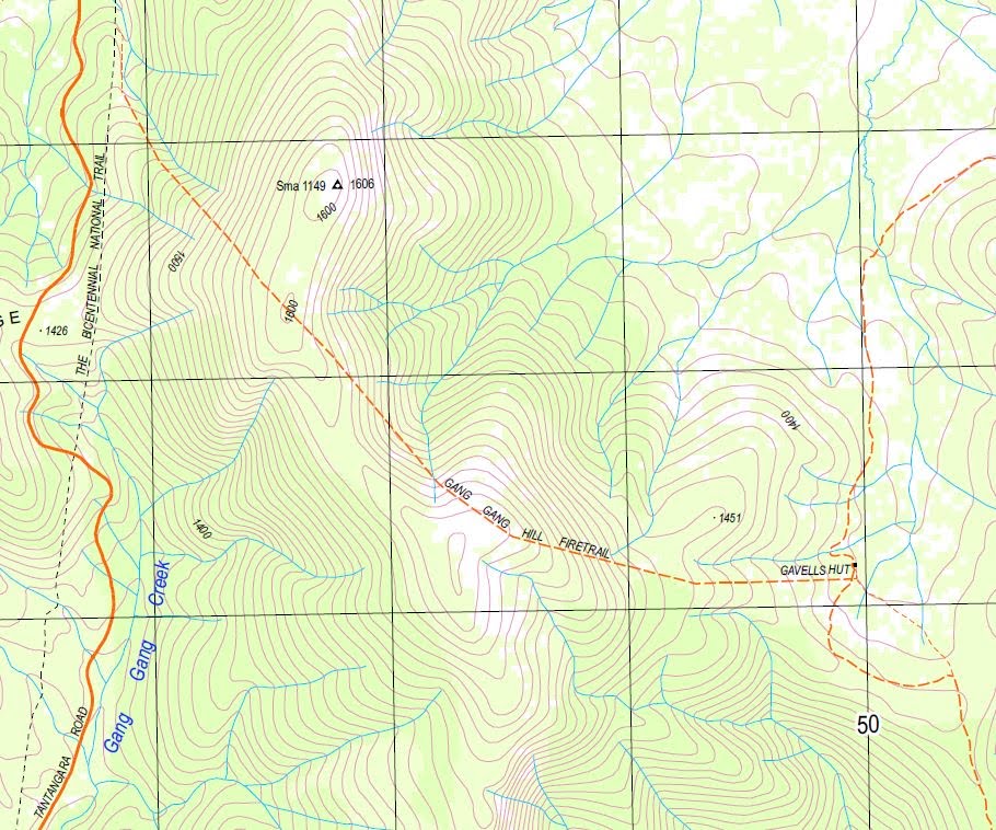
So I spent some time during morning tea looking for this nearby fire trail. No vehicle track in sight. But a worn ditch of a horse riding trail headed off to the west from just near Gavells Hut (the start is a little indistinct), so we tried that.
It took us in our desired direction, up towards the crest of the Monaro Range. It suddenly clicked – the named Gang Gang Hill ‘Fire Trail’ is indeed a horse riding trail!
Easy and quick walking got us to the open crest, 2km in 35mins. Here we were on top of the Murrumbidgee-Eucumbene tunnel.
We continued on the horse trail for another 1.3km in 15mins. Here it continued NW down the other side of the Range, so we struck off through lovely open going to reach SMA1149 (not 1149m ASL, but 1606m).
Some views down to the Nungar Plain and west to the wooded Tantangara Mountain, particularly when we moved slightly to the west side of the crest.
We retraced our steps 2km in 25mins to the crest above the tunnel. Here we picked up a footpad going south along the top of the range and followed it for a while, until it began to drop off to the west. Very pleasant walking as the crest dropped down to a shallow saddle, then up to Gang Gang Mountain. 2.7km in 45mins for this leg.
Lunch at Gang Gang Mountain, with filtered views to Lake Eucumbene. The wooden Goorudee trig lay on the ground. A Facebook post and call home.
Phillip had chosen an excellent homeward leg, first descending along the crest a little E of S, then E and SE down spurs to Boundary Trail. A fraction heavier vegetated on this SE flank of the Range, as expected, but still pleasant walking. A lovely stand of trees at 1420m. This leg 4.1km in 1hr 20mins.
A very well executed trip and great company. Thanks Phillip and all.
Track Maps

Party
6 walkers – Meredith H, Ming L, Stephen M, Terrylea R, Phillip S (leader), me.
Terrylea Reynolds
6 April , 2018 4:53 pmA great indeed through very pleasant country. Bonus was the outstanding day, weather-wise and the exceptional company. Well done Phillip S for organising this super trip.