
Sunny Corner weir on Condor Creek
Saturday 5 October: Two Walks in the Brindabellas – M/M-R. The first walk follows a very overgrown trail, which includes the burnt-out Reids Pinch North arboretum, down to the sunny corner weir on Condor Creek and geocache GC2Q54N Weird Weir VII – Sunny Corner. Around 5km and 200m climb. Next, from Piccadilly Circus, a stroll along Two Sticks Road and the ACT border to SH1326 and geocache GC4XYXP Marking our territory . Around 6km and 150m climb. Map: Cotter Dam. Leader: John Evans 0417 436 877 john@johnevans.id.au . Limit: 12. Transport: ∼$12 per person.
Further Information
I was last here on 13 May 08.
Summary
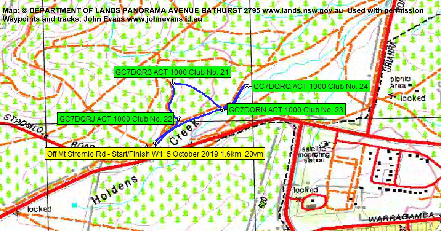
Walk 1 Distance: 1.6km | Climb: 20m | Time: 7.45am – 8.15am (30mins)
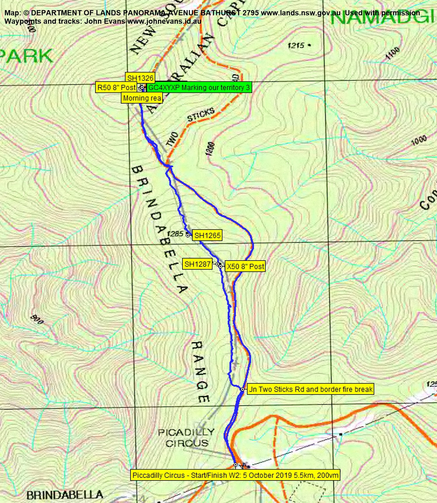
Walk 2 Distance: 5.5km | Climb: 200m | Time: 9.00am – 11.35am (2hrs 25mins), including 25 mins of breaks
Walk 3 Distance: 4.7km | Climb: 2000m | Time: 11.50am – 2.55pm (3hrs 5mins), including 25 mins of breaks
Total Distance: 11.8km | Climb: 420m | Grading: M/M-R; M(10)
Photographs
Photographs are available, where you can start a large sized slideshow.
Video
Waypoint and Track Files
Download the gpx file for this trip (if your browser does not automatically download the file, it will open the gpx file in a new window and you can then save it). To use in Google Earth, do File, Open… and select Gps or All files as the File Type.
Track Notes
Walk 1
A bit damp overnight, so in order to let the scrub dry a little (a poor excuse), we did a little caching just off the Mt Stromlo Rd. I should have come here years ago, because the first cache we did, GC7DQRJ ACT 1000 Club No. 22, celebrated 6 geocachers reaching their 1000th cache. It included me. Thanks very much cache owner sol de lune.
Whilst there, we did another three, GC7DQR3 ACT 1000 Club No. 21, GC7DQRN ACT 1000 Club No. 23 and GC7DQRQ ACT 1000 Club No. 24.
Walk 2
The showers had stopped, but I thought it best to do the higher walk next, so we drove to Piccadilly Circus and parked.
We walked in Two Sticks Rd a few hundred metres to a junction with an old fire trail shown on the Cotter Dam 1st edn map. It paralleled Two Sticks Rd and ran along thr ACT-NSW border. It was very difficult walking, as it was clear authorities wanted no one to drive or ride along it.

Old fire trail paralleling Two Sticks Rd
It was so difficult to constantly step over the trees and saplings that we spent some time walking beside it.
I had a few border markers with me, but they are becoming more difficult to find in the bush litter and grasses. However, we did find X50.

Border marker X50
The old fire trail heading up to SH1326 and our objective was quite pretty in the mist, with wattle still in flower at this higher altitude.

Wattle on the old fire trail heading up to SH1326
It was a bit of a puff for us all.

Happy walkers on the old fire trail heading up to SH132
We made the top and identified border marker R50.

Border marker R50
contesta made the find of GC4XYXP Marking our territory 3 and we logged it. We had morning tea.
We returned down the fire trail and walked back along Two Sticks Rd to Piccadilly Circus.
Walk 3
I had several starting points for our next walk, but we drove to the Namadgi National Park sign at Reids Pinch and parked there. I headed down through the surprisingly light scrub directly to the waypoint W22Q54N Ex-Arboretum pipes, where we picked up a clue for our next geocache.
I didn’t have the required track turned on in my GPSr, so blindly continued along the disused access to Sunny Corner weir. Quite a surprise when we ended up just below the waypoint W12Q54N GC2Q54N Trail Head on the Brindabella Rd! (Actually, it is very difficult to see this start point down off the side of Brindabella Rd when driving. Turned the track display on in my GPSr (blush). But the error gave us the opportunity to head off track down to rejoin the access track, Again, surprisingly light scrub. We passed a bleeding tree.

Bleeding tree on our off track shortcut to Sunny Corner weir
The benched old access track provided a variety of going. On part of the descent, we went down to the nearby open parallel gully. Back up on the track, it was sometimes easy.

Easy going on the Sunny Corner weir access track
And sometimes not so easy.

Not so easy going on the Sunny Corner weir access track
Some colourful Hardenbergia trackside at one point.

Hardenbergia on the side of the Sunny Corner weir access track
At last we reached the weir, found the rest of the clues, worked out the final GZ of the cache (of course, it’s not shown on any track map) and had lunch in this lovely location.

Sunny Corner weir
On our return journey I followed the access track all the way back to the Ex-arboretum pipes waypoint, then we scrambled up to rejoin Brindabella Rd. I reckon the hardest part of the walk was making the last 2 metres up the gravel bank of the road verge!
Some time during the day we logged the final GZ of GC2Q54N Weird Weir VII – Sunny Corner.
Thanks to our non-cachers for putting up with our madness. A couple of reasonably ok little walks. Thanks all!
Track Maps
Track Walk 1
Track Walk 2
Track Walk 3

Party
7 walkers – Tjasa (Tash) B W, Sarah S, Diana T, me.