
Fabulous first time CBC leader Megs on Thunder Bluff
Monday 7 October: Thunder Bluff – L/R,ptX. Thunder Bluff is a granite outcrop to the south-west of Orroral Hill with good views of many of Namadgi’s peaks. We’ll start in the Orroral Valley and follow the Nursery Swamp track for a couple of kilometres then head west, initially on a foot-pad, to a saddle between Nursery and Rendezvous Creeks. From there we head off-track through patches of thick scrub with some steep climbing to the outcrop, the views, and perhaps a geocache for those who are that way inclined. Return roughly the way we came. Leader: Megs B.
Further Information
My previous trips to Thunder Bluff were 26 Oct 16, 26 Oct 10, 29 Apr 08 and 9 Aug 06.
Summary
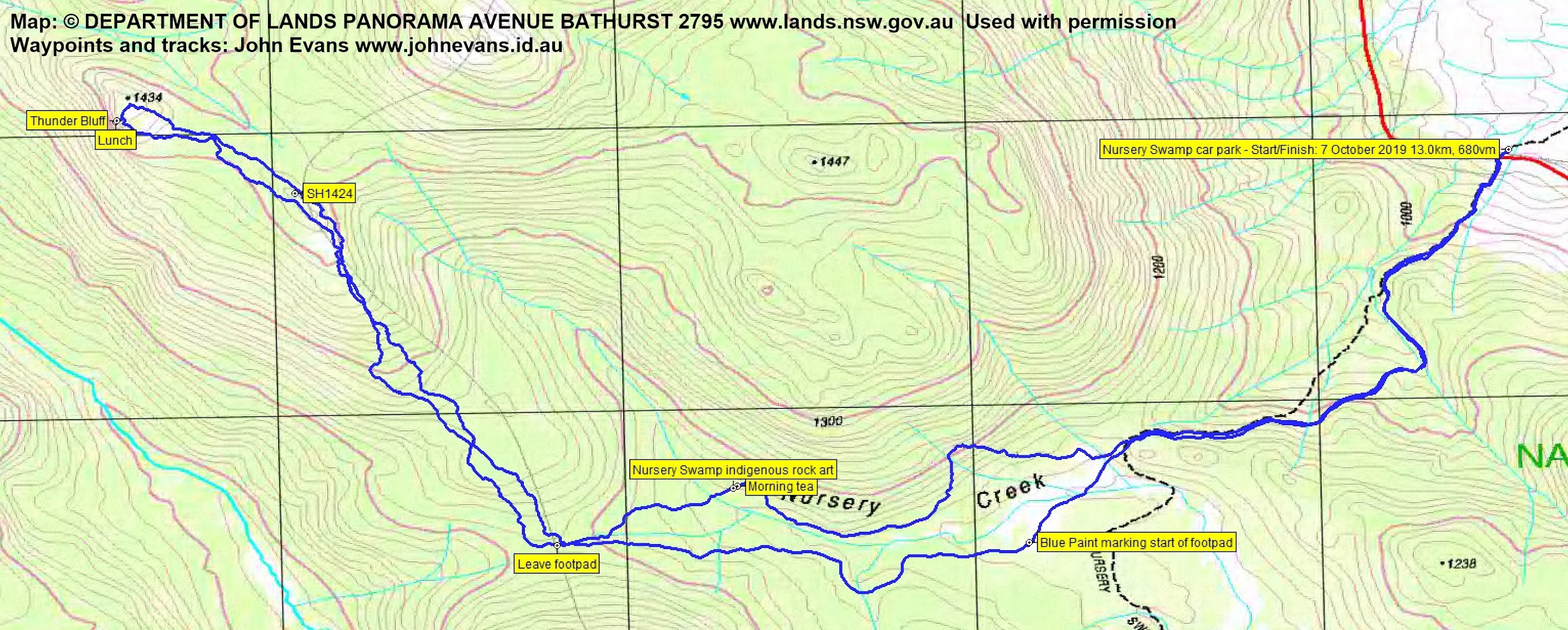
Distance: 13.0km | Climb: 680m | Time: 8.50am – 4.30pm (7hrs 40mins), including 50 mins of breaks | Grading: M/R; H(12)
Photographs
Photographs are available, where you can start a large sized slideshow.
Video
Waypoint and Track Files
Download the gpx file for this trip (if your browser does not automatically download the file, it will open the gpx file in a new window and you can then save it). To use in Google Earth, do File, Open… and select Gps or All files as the File Type.
Track Notes
We met in the Lanyon Marketplace car park and left around 8.15am. 5 of us in each of 2 cars. Drove to the Nursery Swamp car park.
Away at 8.50am at a cracking pace, making the Nursery Swamp Walking Track turn off point, 2km with 200vm climb, in 31mins. I was exhausted.
We then turned towards the Nursery Creek rock art and covered to there, 1.5km in 55mins.

Nursery Swamp indigenous rock art
Morning tea was called.
Recovered, we headed SW to the saddle in the footpad to Rendezvous Creek. From here it was off track in thick scrub NW to SH1424.But there were two slabs which provided views. The first to close at hand granite and wattle.

A pause at 1240m contour

Wattle and granite at 1240m
The second gave is first views over Rendezvous Creek to the Mavis Ridge.

A small slab with a view at 1390m SSE of SH1424

The Mavis Ridge from a small slab with a view at 1390m SSE of SH1424
It was a pretty scrubby climb from the E-W footpad up to Thunder Bluff, the 2.4km and 200vm climb taking 2hrs.
Our wonderful first time leader just loved the views and did a fantastic job of leading.
Two of the party did a little geocaching and we all enjoyed the incredible views.

View over Rendezvous Creek to the Mavis Ridge from Thunder Bluff

View over Rendezvous Creek to the Mavis Ridge from Thunder Bluff

View over Rendezvous Creek to the Mavis Ridge from Thunder Bluff
Of course there was the usual high hill/Percy celebration, although we missed the other usual celebrator.

Thunder Bluff, a Percy, is celebrated
We left Thunder Bluff at 11.25am and returned pretty much the same way. A blue tongued lizard on the NSWT.

Blue tongued lizard beside the Nursery Swamp Walking Track
Megan took a big bite with this trip as a first one. She chewed it up and spat it out. Very well done. Expect more. Great party.
Track Map
Track
Party
10 walkers – Meghan B (leader), Robyn H, Richard H, Stephen M, Quentin M, Lisa Q, Justin S, Diana T, Ian W, me.
John Hall
8 October , 2019 6:05 amLoved the pictures of the walk today. Am very much missing our beautiful Australian bush – we have been overseas for a month or so and are now on our way home – and that just makes me want to get home and even more!
Johnny Boy
8 October , 2019 8:33 amIt’s waiting for you John 🙂