
11.18am A spell below our objective | photo Craig L
Monday 29 May 2023: McKeahnie trig * – M/M-R,ptX. Reconciliation Day public holiday – what better way to celebrate the caring for country by traditional owners than a walk in the bush. McKeahnie trig was built in 1896 by Surveyor R C Gordon. It sits atop high boulders and it’s thought that sapling ladders were constructed to get men and rocks up to the difficult site. It’s in the style of the grand old stone NSW trigs such as Gudgenby and Gooroo. Let’s visit! After leaving the Orroral Lookout trail near the intersection with the Square Rock Track, the route is off-track along a vague ridge. It was very scrubby last time I visited and is now probably choked with regrowth – I really have no idea, hence eXploratory. There is a final 100vm climb to the trig. Return the same way. Around 14km and 550vm climb. Last recce-d in 2017.
Summary
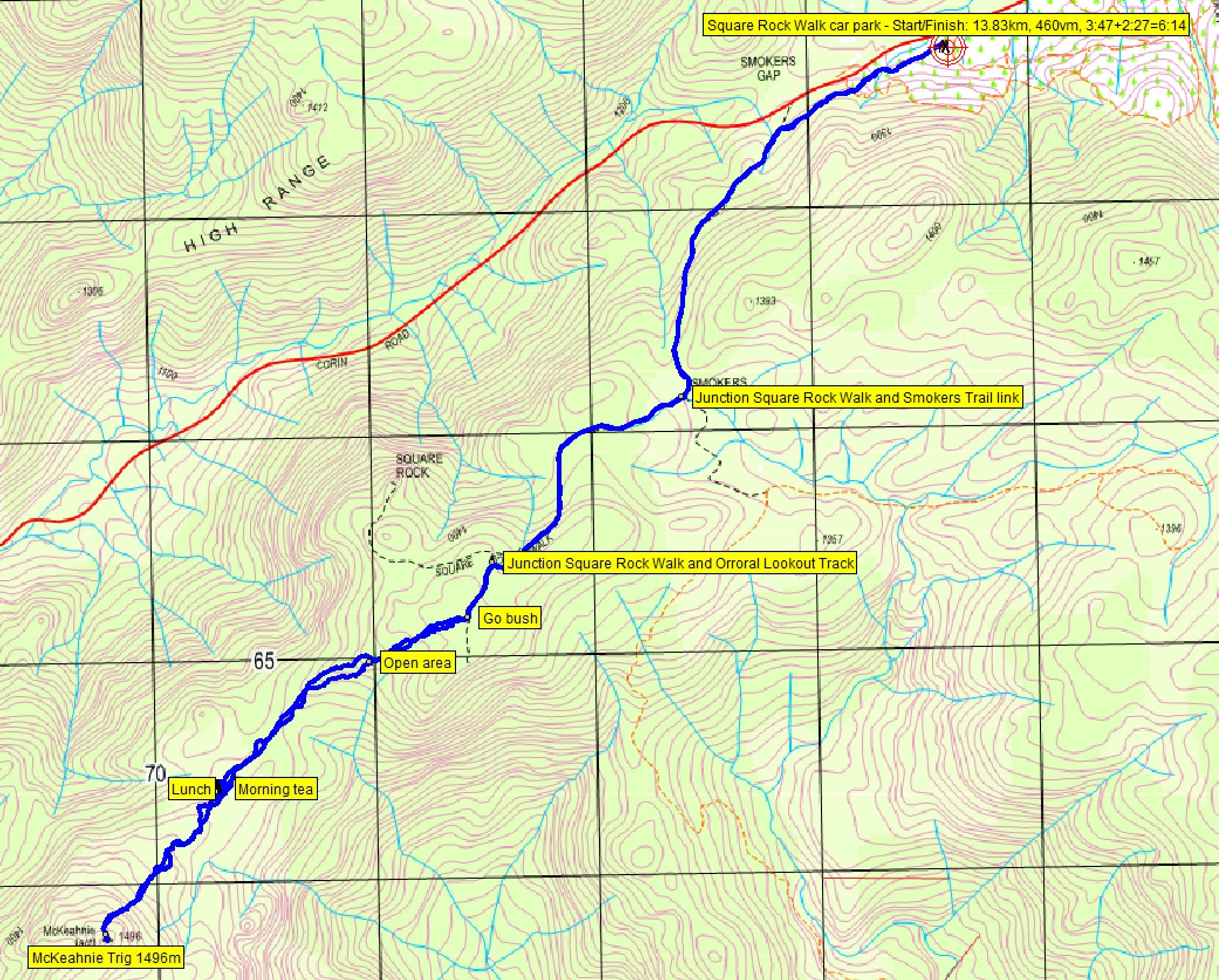
From Garmin Connect (MAP66i) – Distance: 13.83km | Climb: 460vm | Time: 3:47 moving + 2:27 of stops = 6:14 | Grading: M/R; M(11).
Photographs Photographs are available here.
Stupid me left my phone in the car, so huge thanks to Craig L for him allowing me to use his photos.
gpx File The gpx file is available here.
Track Notes
I was last at McKeahnie trig on 26 Aug 17. Six previous trips, dating back to 2004.
Walking from the Square Rock car park by just after 8am. We dispatched the 3.9km to our ‘Go bush’ waypoint in 1 hour.
We had a little talk at the junction of the Square Rock and Orroral Lookout Tracks.
- I was interested to know how many in our 10 strong party had an SOS device. By that I meant a PLB or a GNSS (Global Navigation Satellite System) transmitter, such as an inReach equipped digital device. Pleased to see we had 4 of them.
- I didn’t ask for a show of hands as to first aid kits, hoping that there would be 10/10.
- With just about everyone having some sort of digital navigation device these days, it’s also important that other party members apart from the leader, know the walk plan. I’ve gotten into the habit of publishing a link to my proposed walk gpx file on my blog, hoping that a keen (and safety conscious) person walking with me might load it up.
Turning off the Orroral Valley Lookout track, we were immediately confronted by some of the worst going of the trip.

Unfriendly going at 9.11am between ‘Go bush’ and ‘Open area’ | photo Craig L
The ‘Open area’ waypoint provides a good check point, once it is reached.

Approaching the ‘Open area’ at 9.26am | photo Craig L
A 580m in 25 minutes leg from ‘Go bush’ to ‘Open area’. There’s a circle of placed stones on the slab which I thought could be an indigenous arrangement, but not sure.
However, the slab provides grand views to the way ahead and also ‘Dutchies Peak’ and Mt McKeahnie.

9.32am We’re heading up there – McKeahnie trig knoll from ‘Open area’ | photo Craig L
The next leg from ‘Open area’ to ‘Morning tea’ was 1km in 40 minutes. The SW exit down the rock face from the viewing point was a bit sloppy, the return later in the day from the W better. But the going eased once we got out of the fallen trees and there was mainly supple shrubs to contend with.

Fire damaged tree falls cleared and shrubby regrowth made for easier going 10.01am | photo Craig L

The going at 10.01am | photo Craig L

Approaching morning tea at 10.29am | photo Craig L
A short morning tea break in the fleeting sun and cool wind.
The final leg to the destination was another 1km in 40 minutes, including a 130vm climb.

10.52am Beginning the climb at 1420m to the trig knoll | photo Craig L
A few wombat tracks made for easier walking on this leg. We passed through the swampy area and enjoyed a relatively easy climb up to the top of the knoll.

10.59am Getting in amongst the tors at 1450m | photo Craig L
More by luck than good planning, the final entry to the trig area was better than I’d ever experienced. We ducked through a small gap in the towering tors, directly under the trig on its enormous boulder. Turning around and looking up, there it was.
I enjoyed a good sit down whilst others had a look about.
11.18am A spell below our objective | photo Craig L
We returned the way we came, even lunching at the morning tea spot.

12.10pm A cold lunch | photo Craig L
I was most appreciative of Stephen M taking the lead from the ‘Open area’ to the ‘Go bush’ waypoint. He was, of course, well equipped with the proposed route in his GPSr prior to the start of the trip. He seemed to find fewer logs to clamber over than on my inward route. And, of course, taking up the tail end Charlie position, I enjoyed walking through the bush that’s been bashed by 9 others in front!
Quite a few other walkers on the Square Rock Track as we returned.
A good trip, made great by the bunch of people I walk with. They sure are a chatty group. Thanks all.
Track Map
Here’s where we went.
Track McKeahnie Trig
The AllTrails map is here, where you can pan and zoom.
Party
10 walkers – Stephen J, Ming L, Craig L, Stephen M, Daniel P, Michael R, Lam S, Tilly T, Sandra T, me.
Johnny Boy’s Walkabout Blog FaceBook Page
I’ve started up a FaceBook page. Each trip report posts to it. So it’s another way to get some info to get out and breathe a bit of fresh air. Why not pop over and Follow the page, or give a post a Like.