
Inside the split tor holding geocache GC5QW3X Broken Boulder
Thursday 22 August: Corin Rd caching again – S/R,ptX. Another half day geocaching on either side of Corin Rd.
Further Information
Similar to 24 Jul 19. Another couple of small caching trips. This time I publish this post to encourage walkers to go up and have a look at these absolutely wonderful locations. Magnificent tors! These geocaches have been placed by a great CO, Tankengine. I have no idea how he finds these places, but he has taken me to some wonderful tors and views. Hats off to Tankengine!
Summary
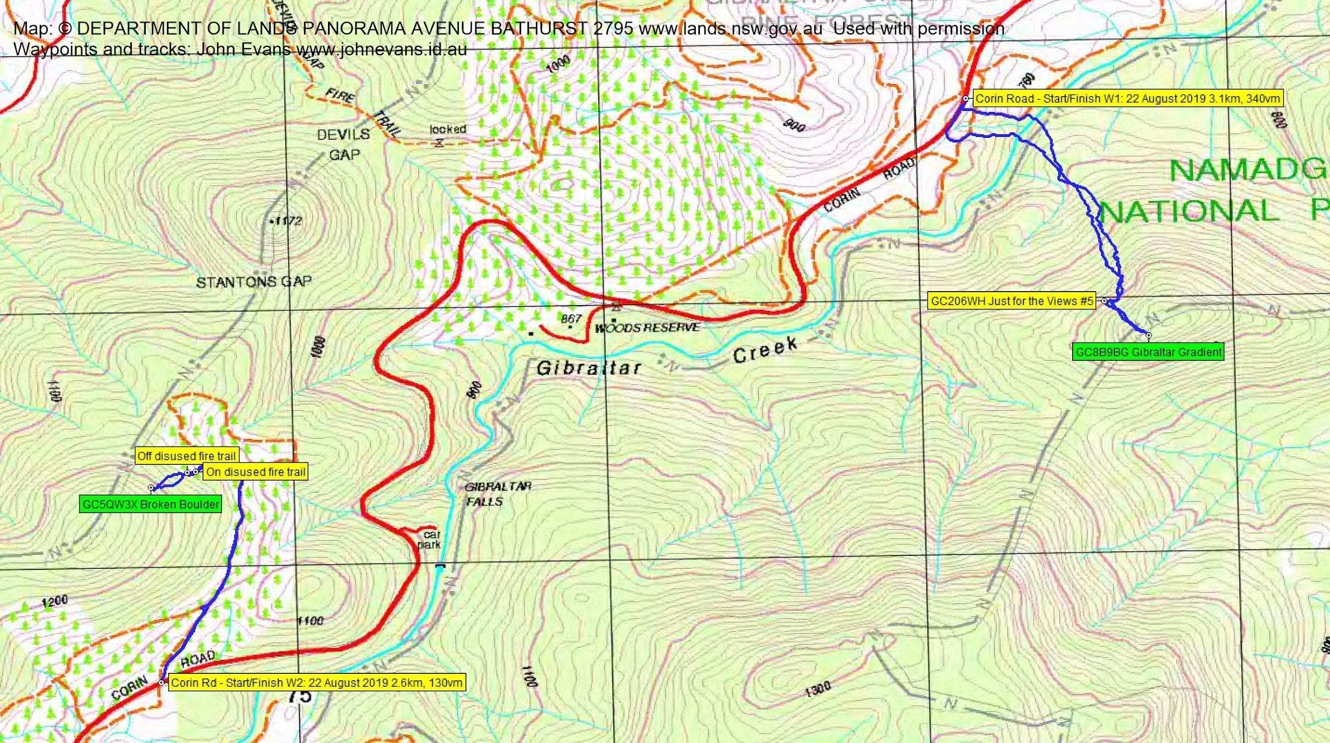
Walk 1 – Distance: 3.1km | Climb: 340m | Time: 11.30am – 2.40pm (3hrs 10mins), including 40 mins of breaks
Walk 2 – Distance: 2.6km | Climb: 130m | Time: 2.45pm – 4.00pm (1hr 15mins)
Overall Grading: S/R; M(10)
Photographs
Photographs are available, where you can start a large sized slideshow.
Waypoint and Track Files
Download the gpx file for this trip (if your browser does not automatically download the file, it will open the gpx file in a new window and you can then save it). To use in Google Earth, do File, Open… and select Gps or All files as the File Type.
Track Notes
Met at my old folks home and drove up Corin Rd to a safe verge park for the start of the SE walk.
Walk 1
Down and across Gibraltar Creek then, after pushing through the creek-side band of scrub, a slow and steady climb. The going is relatively sparse, but steep. We stopped for the others to log GC206WH Just for the Views #5. Great views they are.

View down to Corin Rd from geocache GC206WH Just for the Views #5
Then on another 200m to the next cache. Again the going was relatively easy, but the terrain rating for this cache was 4.5/5. It was only when we got to do the last 10m, by scrambling up on top of a tor, did we appreciate the rating! Huge views and a log of GC8B9BG Gibraltar Gradient.

View to a nearby 1300m knoll from geocache GC8B9BG Gibraltar Gradient
A careful return to ground level, then lunch with views down to the Booroomba property. I’ve never seen it from this angle before.

View down to the Booroomba property from geocache GC8B9BG Gibraltar Gradient
We trundled back down the hill and recrossed Gibraltar Creek.

Crossing Gibraltar Creek
Back up to the car and drove further up Corin Rd to another safe verge park at the start of a decommissioned fire trail.
Walk 2
We followed this fire trail up till we were NE and nearest to our next objective which was located on the flank of a knoll SSW of The Pyramid (SH1172) and Stantons Gap on the rim of Tidbinbilla Nature Reserve.
The last few hundred metres of climb were quite steep. A couple of tens of metres on an even more overgrown old fire trail and a final puff up through fallen bark and timber and rocks had us at the opening of a most marvellous slot in a tor. 10 metres in through the squeezy crack had us logging GC5QW3X Broken Boulder. Another must visit location, with great views.

Huge views from the broken boulder – SE rim of TNR, down Corin Rd to Paddys River
After taking in the views, we rolled back down the hill. Again used the derelict fire trail.

The old disused fire trail
Back down to the car and so home.
A most wonderful few hours. Thanks Diana and Quentin. And thank you Tankengine!
Track Map
Track
Party
3 walkers – Quentin M (Fred45), Diana T (contesta), me (JohnnyBoyACT).