
View NW from geocache GC8AX4Z Booroomba Back
Wednesday arvo 24 July: 2 short walks off Corin Rd – M/M-R,X. Climb off-track to the second knoll to the east of the bottom of Corin Rd, SH985. Around 3.5km and 280m climb return. Next, from a higher corner on Corin Rd, walk fire trail to Devils Gap then up off-track to the knoll opposite The Pyramid. Continue on fire trails to another location. Around 5km and 250m climb return. Hunting geocaches. Map: Tidbinbilla. Leader: John Evans 0417 436 877 john@johnevans.id.au . Transport: ~$5. Book by 9pm Tuesday.
Further Information
Traditional geocaches keep appearing in Namadgi National Park, so I have to keep finding them.
Summary
Distance: 9.3km | Climb: 500m | Time: 12.40 – 2.30pm, then 2.45 – 4.40pm (3hrs 45mins) | Grading: M/E-M,X; M(9)
Photographs
Photographs are available, where you can start a large sized slideshow.
Waypoint and Track Files
Download the gpx file for this trip (if your browser does not automatically download the file, it will open the gpx file in a new window and you can then save it). To use in Google Earth, do File, Open… and select Gps or All files as the File Type.
Track Notes
Incredible that our little weekly caching run attracted 7 starters. And, once again, one of our destinations provided fabulous views.
We motored up Corin Rd in two vehicles to the furthest start point, having chosen to do the easier, mostly fire trail walk first.
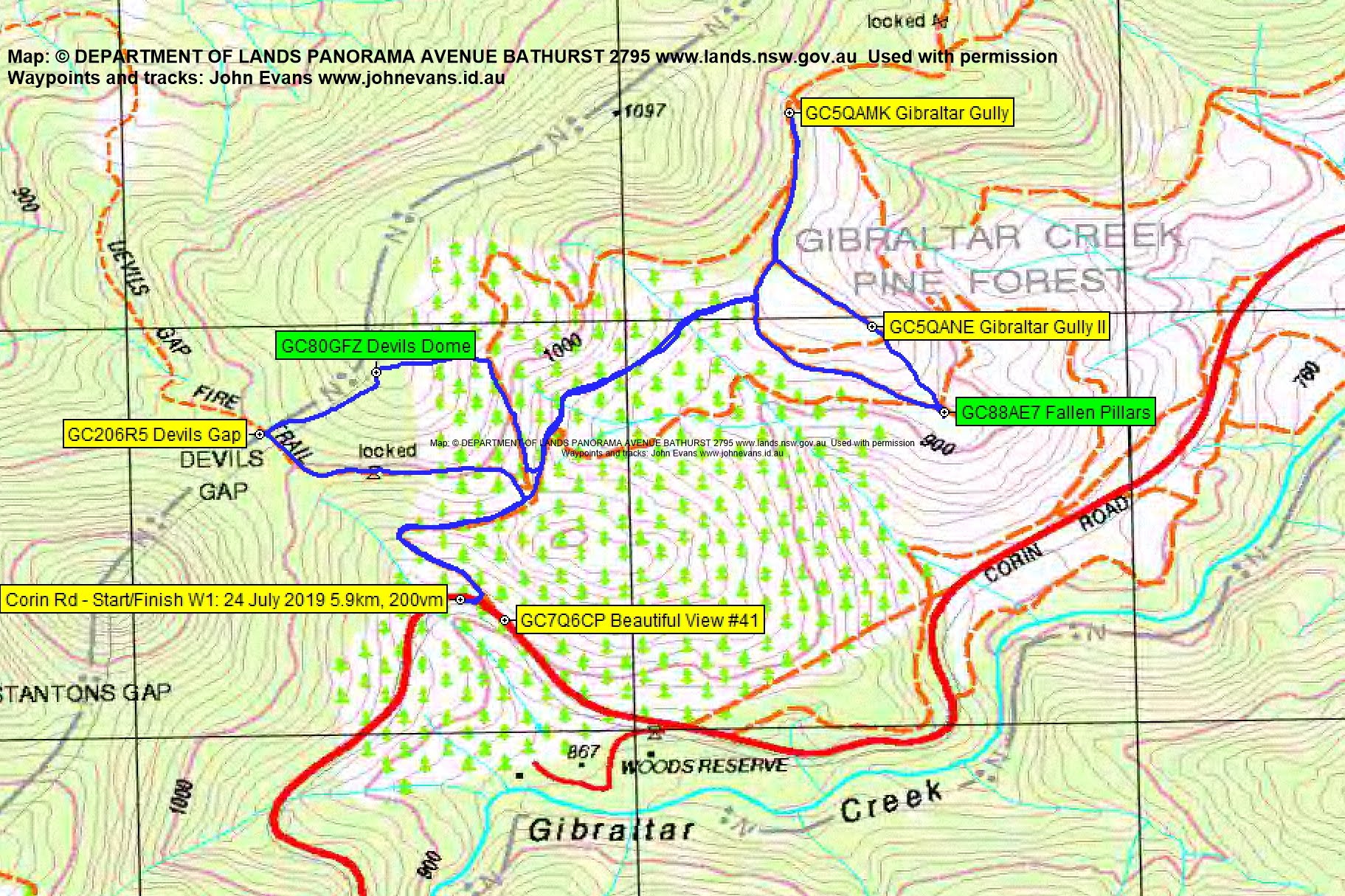
Walk 1
The Devils Gap fire trail took us up and generally NW to Devils Gap, where Diana made a quick find and log of GC206R5 Devils Gap. We then headed up through pretty open scrub to the NE knoll above the Gap, opposite The Pyramid. A find and log of GC80GFZ Devils Dome for us all. Next, an off-track descent to the east to pick up a fire trail. This took us, via a detour to GC5QAMK Gibraltar Gully and down to GC5QANE Gibraltar Gully II for Diana, then a little off-track, to GC88AE7 Fallen Pillars for us all to log.

Hardenbergia at geocache GC88AE7 Fallen Pillars
A comedy of errors as we approached. The dopey walk leader and cacher hadn’t brought the spoiler picture – with one bar of 3G I got onto geocaching.com, navigated to the spoiler with my phone basically above my head then, not being completely in control of the technology, had to get another to take a photo of my screen.
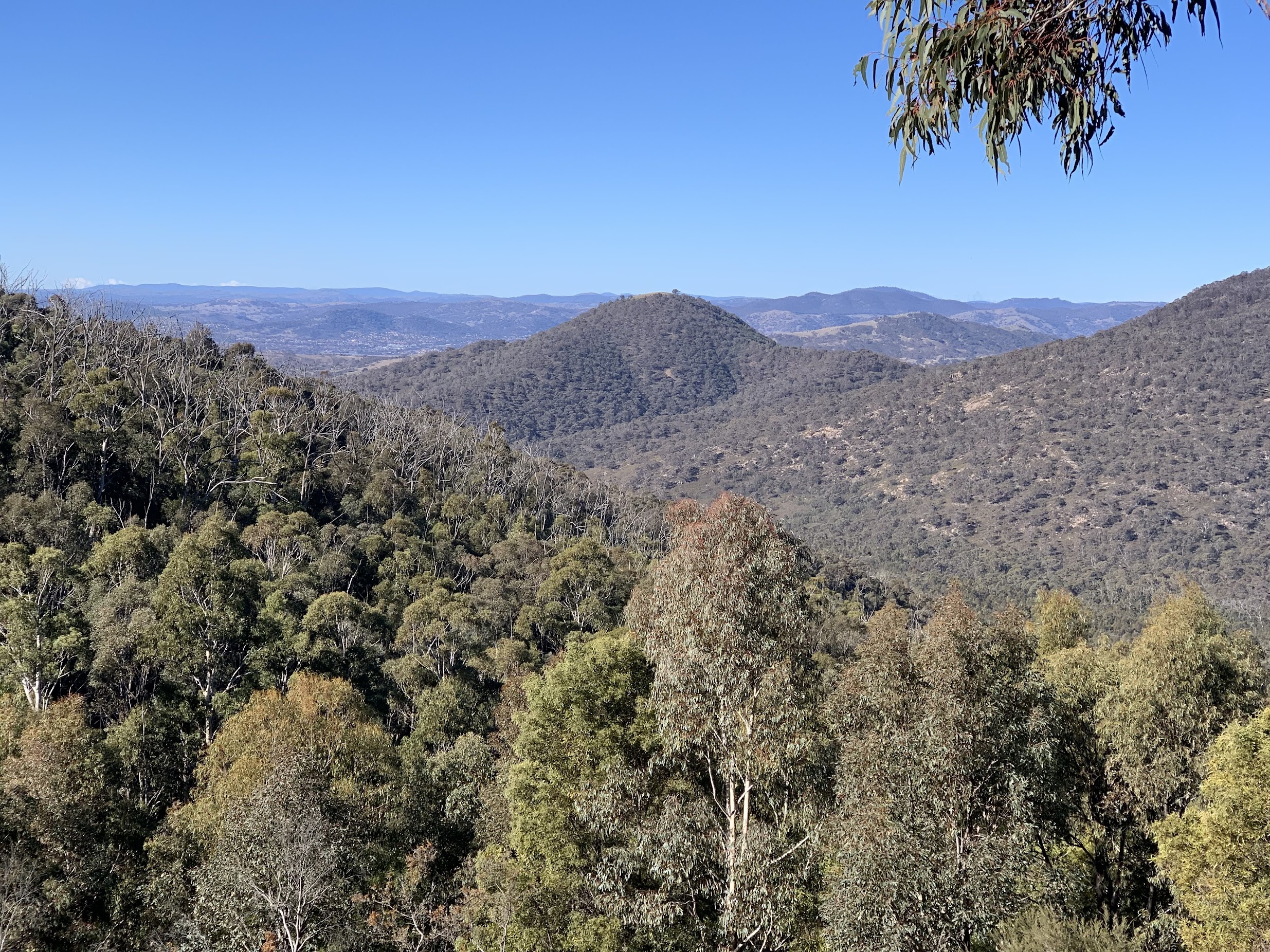
A nice view to the knoll we had to climb on our second walk.
Returned to the cars via fire trail, Diana picked up GC7Q6CP Beautiful View #41, then we drove back down Corin Rd.
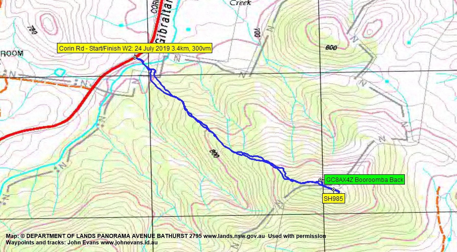
Walk 2
We stopped on the side of Corin Rd, very near the northern end of the tongue of Namadgi National Park that sticks out here. Walked down and crossed Gibraltar Creek. Headed straight up the spur to our final cache of the day, this one in NNP. A little tree climb to retrieve and log GC8AX4Z Booroomba Back. Nice views to the north.

View to the south Bullen Range and Miowera Hill from SH985
But even nicer views when we continued on a hundred metres or so to SH985 and a little beyond.

View over the Booroomba property from SH985
Yet another example of the places one normally wouldn’t walk to but to find a geocache. This cache owner, Tankengine, is a whiz at finding locations such as this.
A bee-line back down and so home after a little part-day cache.
Thanks all, whatever your reason for coming out this arvo.
Track Maps
Track Walk 1
Track Walk 2
Party
7 walkers – Roger E (Marmaduke Rothschild), Roger H, Karen McC, Nancy M, Phillip S, Diana T (contesta), me (JohnnyBoyACT).