
The Pimple and Burkes Creek on its wild plunge to the Cotter River
Wednesday 31 July: Tidbinbilla Mountain to Johns Peak Traverse – L/R. A grand winter mountain walk with great views. From the Mountain Creek Car Park we start along the Lyre Bird Trail and then ascend steeply to near Snowy Corner and from there to the summit of Tidbinbilla Mountain. The ascent to Tidbinbilla Mountain is steep, rising some 700 m. The footpad is often loose and stony and not always well defined. From Snowy Corner there will be some off track, some light scrub, and some rock scrambling. From Tidbinbilla Mountain the undulating ridge to Johns Peak is mostly along a faint footpad, but there may be off track sections with light scrub. From Johns Peak there is a rough, steep, short descent to a ridge which links to the Camels Hump Trail which we follow back to the cars. It will be very cold, so bring appropriate clothing. Also, gaiters and scrub gloves could be useful. Leader: Barrie R.
Summary
Distance: 12.7km | Climb: 950m | Time: 8.20am – 3.20pm (7hrs), including 60 mins of breaks | Grading: L/R; H(12)
Photographs
Photographs are available, where you can start a large sized slideshow.
Video
Waypoint and Track Files
Download the gpx file for this trip (if your browser does not automatically download the file, it will open the gpx file in a new window and you can then save it). To use in Google Earth, do File, Open… and select Gps or All files as the File Type.
Track Notes
It’s been a while since I’ve done a Wednesday Walk and even longer since I’ve walked with today’s leader. He has a few years on this 70 year old codger and he still walked me into the ground. Excellent navigation too. This, coupled with a blue-sky, windless day, made for perfect conditions on the Tidbinbilla Range crest. Fabulous views all round!
My dear wife pulled up well after yesterday’s little medical procedure, so I was given a late leave pass. I drove myself out to the Mountain Creek car park (just in case I had to skidaddle home quickly) and met the others there. -3°C.
A pleasant walk along the Lyrebird Trail amongst the wet regrowth and feeders to Mountain Creek just running. The pad leaving the Lyrebird Trail is well developed and you can’t miss it now. It takes walkers up to a little crest, along a section of the old Lyrebird Track to the bottom of the spur footpad which rises to the ‘Snowy Corner cairns’. Again, you can’t miss this either.
Although still cool, we stripped off layers for the steep climb. We took a break at the two stools about half way up.

View over Tidbinbilla Nature Reserve from the 2 benches on the footpad to Snowy Corner cairns
After that, the last 200vm seems a little easier. An AB site was pointed out to me.
Without a pause at the cairns, we did a right turn and followed a good footpad through pea regrowth to the open area which is closer to the map-marked Snowy Corner location. Morning tea was called. Although the logs we still frosty, the sun shone on us and there was no breeze.
The entire footpad for the trip is relatively easy to follow (you should still have map and compass/GPSr and good route finding skills).
Passing the 1500m contour to the SE of Tidbinbilla Mountain, our leader by design continued NW to nearly the NE of our objective to give us a more gentle climb to the top.
Grand views all round!

View SW from Tidbinbilla Mountain to Corin Dam

Walkers on Tidbinbilla Mountain
We exited the top to the NE, following the crest generally NE. After the rocks and regrowth is negotiated, the descent is through lovely open woodland for a few hundred metres. Was this what Namadgi walking was like prior to the 2003 fires?

Open going coming off Tidbinbilla Mountain to the NE
But not for long, the going closing in around the area where you turn off to The Pimple.

Tighter going approaching the cairned turnoff to The Pimple
Our leader offered us the option of going there, but we declined.
The next leg along the crest is a bit scrubby too.

An open patch between SH1555 and SH1556

Looking back to Tidbinbilla Mountain and the way we came
But finally out into the open and the last gentle climb to the cairn near SH1556.

The Pimple and Burkes Creek on its wild plunge to the Cotter River
From here, left turn along the footpad up to Tidbinbilla Peak. Here we had a relaxed lunch and I called home.

Tidbinbilla Mountain and The Pimple from Tidbinbilla Peak
From here, the footpad is well developed such that even I could follow it. It descends gently to the NE to SH1491, then turns more to the east to Johns Peak. Barrie took us a fraction west of the footpad on a lovely rocky approach to Johns Peak.

Heading up to Johns Peak
It does provide fabulous views down into Burkes Creek.

The north arm of Burkes Creek and Camels Hump from near Johns Peak

The way ahead from Johns Peak
We scrambled down the steep descent from Johns Peak, then ambled along the footpad on the crest.

Descending from Johns Peak
An interesting finish to cut the corner, turning down to the Camel Back Fire Trail well before the burnt out tower. This saved us a kilometer or so. (Would be interesting to turn down a spur or two earlier some time.)
A trudge down the fire trail (reported a newly fallen tree to the office) back to the cars.
A really great day, thank you Barrie and all. I never tire of the spectacular views from the Tidbinbilla Range crest!
Track Maps
Track overview
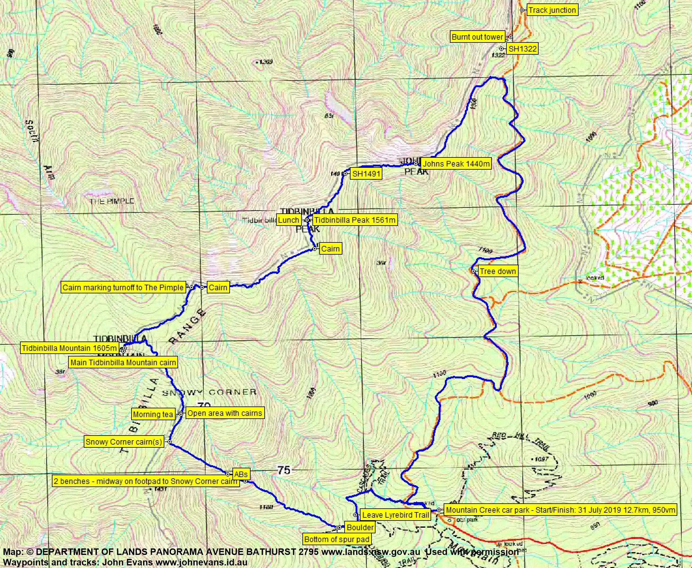
Track overview Tidbinbilla Mountain
Track 1

Track 2

Profile

Google Earth snip

Party
5 walkers – Jan, Margaret, Barrie R (leader), Mike S, me.
Chris Lowe
1 August , 2019 12:37 pmHi John,
I ran into you guys at Tidbinbilla Peak – not sure if you remember. Lovely day, was great to be up there. Interesting to read your account, thanks.
Chris Lowe
Johnny Boy
1 August , 2019 12:48 pmHi Chris. So sorry, I didn’t recognise you. Where were you off to? Cheers. john
barrie001
1 August , 2019 3:06 pmHi John
A great day and a great party. Many thanks for your most kind comments.
This post is one of your best – superb photos and great script, together capturing the very spirit of place and the day, even down to the frost on the logs.
I am glad that you highlighted the need to have good route finding skills in addition to map/compass/gps for there are places where the pad disappears in patches of scrub and rough terrain and without those skills one could go astray..
For me this high mountain ridge is one of the best, no, the best, walk in the ACT with its feeling of remoteness, good walking, the feeling of being up high, and the most incredible views over stunning wilderness.
This area is so special, so stunning as it is that I would love to see it gazetted as a place of special natural wilderness beauty to ensure that it remains undeveloped. I can live with a footpad through it, though!
Thanks a lot for joining us on this walk. Great to have you there.