
Craig, Ming, Roger, Stephen, John on Little Ginini Mountain (photo Craig L)
Saturday 21 January 2023: Geocaching on Little Ginini Mountain and Mt Gingera * – L/R. Did you know that CBC offers geocaching trips? Join prolific cacher Marmaduke Rothschild and wannabe cacher JohnnyBoyACT to hunt geocaches on the Brindabella Range. Bag Little Ginini Mountain and Mt Gingera for RU⇧4it. A border marker or two thrown in. A long day at a moderate uphill pace, starting from Corin Dam. Around 21km and 1200vm climb. Looking for GC9NEM0 Stockyard Stops, GC93QF1 Glorious Ginini, GC9NEM3 Gingera Girth and GC9NNA2 Quinquagintaphobia!
Brumbys Flats was added in.
Summary
From Garmin Connect – Distance: 21.90km | Climb: 1416m | Time: 6:28 moving + 2:52 of stops = 9:20 | Grading: L/R; H(14).
Photographs Photographs are available here.
gpx File The gpx file is available here.
Track Notes
I was last on Little Ginini Mountain on 19 Oct 22, on Mt Gingera on 26 Mar 22 and at Brumbys Flats on 15 Jun 13.
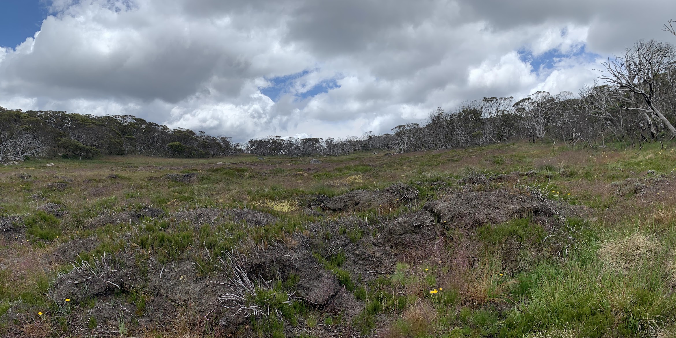
Several joys today – 4 geocaches, 2 hill bags for RU⇧4it, revisited several border markers, lovely walking on parts of the Brindabella crest. But a disappointing return to the Snow gums of Brumbys Flats – some memories are best left that way.
Walking at 7.40am. Nothing to say about the climb up from Corin Dam to the helipad, except that it took me 1:26. Low, foggy cloud in the beginning of the day, the rest mainly overcast (which was handy), a few breaks of sun.
Nothing to say about the rest of the walk to join the Mt Franklin Road. We didn’t even stop at the lookouts as there was no view. Morning tea after we’d found and logged GC9NEM0 Stockyard Stops.
The ascent to Little Ginini Mountain is directly up to the west. We bagged the hill and checked out border marker M57 with its stone central box and the top of a 1″ galvanised iron pipe, driven into the ground over 100 years ago, visible.
Beautiful walking south down the spur to Pryors Hut.

Lovely going heading south from Little Ginini Mountain
That was except for the March flies – 87 swatted during the day and 100 million still there. Found and logged GC93QF1 Glorious Ginini, very near to border marker O57.

Border marker O57
The border corners are marked in a variety of styles. This one a 3″ galvanised iron pipe, filled with concrete, above ground and associated lockspit.
P57 was next, same style. You can see the head of the bolt over which a theodolite was placed.

Border marker P57
Views to where we’d be later in the day.

Northern end of Mt Gingera ridge from border marker P57
We tracked down to Pryors Hut. A party of 5 was camped there so, after saying hello, we walked on so as not to disturb them. It was too early for lunch anyway.

Pryors Hut
The first of quite a few snakes crossed our path as we walked to Snowy Flat Creek and the turnoff to Mt Gingera. Lovely displays of wild flowers, lasting a bit longer at these higher altitudes (1670m here).

Colourful display
We topped up our water and, somewhere along the footpad up to Gingera, logged the final GZ of GC9NEM3 Gingera Girth.

Logging a geocache (photo Ming L)
Further up the track we logged the final GZ of GC9NNA2 Quinquagintaphobia!
More flowers.

ACT’s floral emblem
Reached the guyed pole south of the real Mt Gingera at 12.55pm and took in the view.

The Gingera snowgum not only holds on but grows
The sun happened to be out, so we retreated to some nearby shade for lunch. Rang home.
For our next leg we split the party. One returned down the Mt Gingera track to log a missed geocache and the other four headed down to Brumbys Flats. We had a quick chat with the family group who were camped at Pryors Hut, as they were on Gingera too.
I had a quick look at the northern face of the real Mt Gingera for aestivating Bogong moths – no joy.
The descent to the Flats is delightful. We were surrounded by hundreds of tiny moths. Anyone know what sort?

What moth is that – descending to Brumbys Flats
4 March 2023: Well, thanks to the great service provided through Canberra Nature Map, there little fellows have been identified and confirmed as Small Radiating Carpet (Chrysolarentia chrysocyma).
Easy walking.

Descending to Brumbys Flats
Some unburnt sphagnum on the edge of the Flats.

Sphagnum on Brumbys Flats
The reason for this visit was to return to some huge (burnt in 2003) Snow gums, first seen by me in 2013.

Walkers on the Snow Gum at Brumbys Flats in 2013
Alas, now fallen.

The Snow Gums on Brumbys Flats
But, as in life, new hope springing up nearby.

New life at the Snow Gums on Brumbys Flats
It’s hard walking over tussocky, springy flats, so we headed up into the vegetation line just above the Flats.
Brumbys Flats
Ascended gently to the Gingera ridge and visited U57. In his original field notebook, Mouat described it as “Station on Granite Boulder 1″ Pipe cemented in crevisse [sic] of boulder abt 12′ above ground”.

Border marker U57
Next was T57. A gentle removal (and replacement) of the top rock at the centre of the lockspit revealed a refurbished wooden post with aiming nail head.

Border corner and marker T57
As I explained to one of my companions, it’s like revisiting old friends!
Next were markers S57 and R57, very near SH1847 at the northern nose of the Gingera ridge.

Border markers S57 and R57
Views to some of the places we’d visited.

View from the N Gingera ridge including Little Ginini Mountain and Tidbinbilla Mountain in the distance
At last a descent for my tired body and feet. Nice to see Snow Gum regrowth.

Snow gum regrowth from lignotuber
Another snake incident. I was earning my keep by leading (it was going downhill) and nearly stepped on the end of a snake. Couldn’t tell whether it was the head or the tail, until it took off at a rate of knots.
A quick look at border marker Q57 and the 21 Mile marker near Pryors Hut. Picked up our geocacher.
Then the final slog back. A merry time at Pryors no doubt, as we passed 6 walkers going up to camp, plus the 5 already there. Back at 5pm.
A nice trip, hard for me. Thanks all.
Relive the trip
Track Maps
Here’s where we went. On TopoView2006 NSW mosaic displayed in OziExplorer.
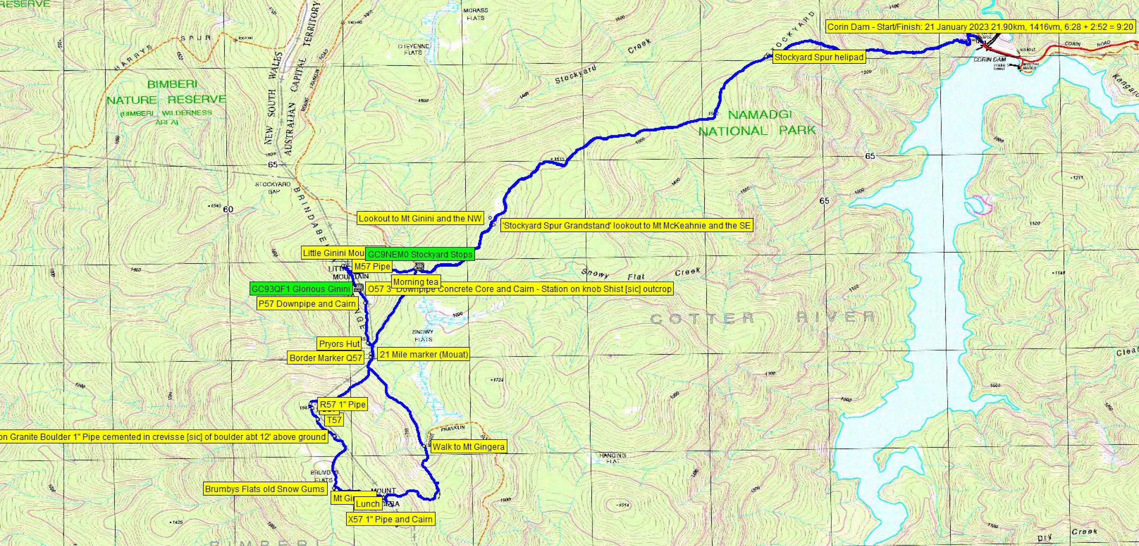
Track overview Geocaching Little Ginini Mountain and Mt Gingera

Track 1 Geocaching Little Ginini Mountain and Mt Gingera

Track 2 Geocaching Little Ginini Mountain and Mt Gingera
The AllTrails map is here, where you can pan and zoom.
Party
5 walkers – Roger E, Ming L, Craig L, Stephen M, me.
Johnny Boy’s Walkabout Blog FaceBook Page
I’ve started up a FaceBook page. Each trip report posts to it. So it’s another way to get some info to get out and breathe a bit of fresh air. Why not pop over and Follow the page, or give a post a Like.
Girts
23 January , 2023 9:27 amGreat blog Johhny Boy, as always! Do you think the wildlife flowers on Gingera will be in bloom round 17 Feb ? ( Last year they looked perfect on 11 Feb.). A pur guess is fine!
Johnny Boy
23 January , 2023 9:39 amYuma Girts. I think as long as the weather remains relatively mild, they’ll still be ok around 17 Feb. Some really beautiful walking up there on a cool/cloud-covered day. Yarra. john