Last updated 11Mar15
Mt Gingera
First Visit
My first visit to Mt Gingera was on 25 May 05 and we visited the guyed pole.

Mt Gingera trig
First visit to high point
On 14 Apr 09 I visited the high point around 100m to the NW of the guyed pole. Also visited the guyed pole.

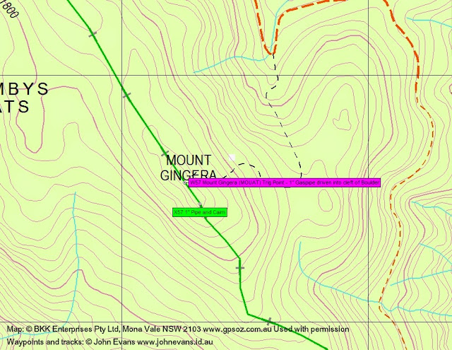
Mt Gingera (MOUAT)
Border markers
The ACT-NSW border marker, about 1m south of the guyed pole, is the (refurbished) Mouat-surveyed border corner X57. Located at UTM 55H 661318.641-6061480.184 (MGA). That’s to the millimeter, as recorded by the ACT Survey Office.

Border marker X57
The ACT-NSW border marker located somewhere in the granite high tors is the Mouat-surveyed and described as ‘Mount Gingera Trig Point: Station 204. 1″ Gaspipe driven into cleft of Boulder. Also designated “M.M” [Mount Mouat?] in Field Books.’ Located at UTM 55H 661255.85-6061566.164 (MGA). I’ve never found this due to the number of boulders, the number of clefts and the amount of leaf litter and other bush debris, despite numerous searches. Anyone got a metal detector?

Page from Mouat’s field notebook
So which is Gingera trig and which is Mt Gingera?
I think my confusion arose from my TopoView 2006 digital maps. This shows the Gingera trig marker at the Mount Gingera high point:

Gingera on TopoView 2006 digital map segment
However, looking at the same area on OZraster digital maps (produced from NSW LPI data in 2011) shows the Gingera trig marker gone:
Gingera on OZraser 2011 digital map segment
Finally, looking at the Gingera area via the NSW Government Land and Property Information Spacial Information eXchange site at http://maps.six.nsw.gov.au/ reveals that the data has been updated to show both Mt Gingera and the Gingera trig:

Gingera on SIX capture
The Coordinate Tool was activated on TS5658GINGERA (ACT). Lat/lon S 35.577235º E 148.780318 is within a whisker of the Gingera guyed pole trig.
Conclusion
The guyed pole is the Gingera trig. Mt Gingera is the highpoint of granite tors ∼100m to the NW.
Leave a Comment