
The windswept snow gum near the guyed pole grows larger as I grow older
Sunday 20 March 2022: Mt Gingera from Corin Dam ! – L/E. See how far I can get up Stockyard Spur.
Summary
Distance: 20.2km | Climb: 1136m | Time: 7hrs moving plus 30mins of breaks | Grading: L/E; M(11).
It felt like I’d joined the mile high club, but 1136m is only 0.7 miles.
Photographs
Photographs are available here.
gpx File
Download the gpx file recorded via AllTrails here (in AllTrails, activate …, Download Route, Select the file format GPX Track, OK).
Another version of the gpx file, recorded on my Garmin Oregon 650 GPSr, is available here. It has quite a few waypoints in it which the AllTrails version doesn’t.
Track Notes
My last trip to Mt Gingera from Corin Dam was on 18 Jul 19, a snow shoe along the top. A better comparison for times under similar conditions as today would be 14 Jun 17.
A steady drive up to Corin Dam. A few rabbits, wallabies and roos about. Misty at times.
I was walking by 7.40am and, as everyone knows who has done this trip, straight into the climb.
Stone steps …

Stone steps heading up from Corin Dam to the helipad
… and wooden steps.

Wooden steps heading up from Corin Dam to the helipad
I was immediately huffing and puffing and the 30mins of breaks for the day included plenty of quick pauses as I climbed. The day began overcast and misty, but glorious as the sun bit through the gloom.

Sun breaks through the mist
The Cotter River valley and Corin Dam below remained shrouded.

Looking back to mist in the Cotter River valley
The long rises and short flats are meant to be represented by the four levels of stone steps at the start of the walk. There seemed to be more today. But at last the sky came down and indicated that the helipad was getting closer.

Getting closer to the helipad
Arriving at last, I took a screen shot of the AllTrails stats.

AllTrails stats at the helipad
My previous best time to here was 55 minutes. Oh how the ravages of health issues and old age slow one down!
The Stockyard Spur track levels off here for a while and it was pleasant walking.

Walking the Stockyard Spur track
There’s a bit of a down and up between SH1532 and SH1615.
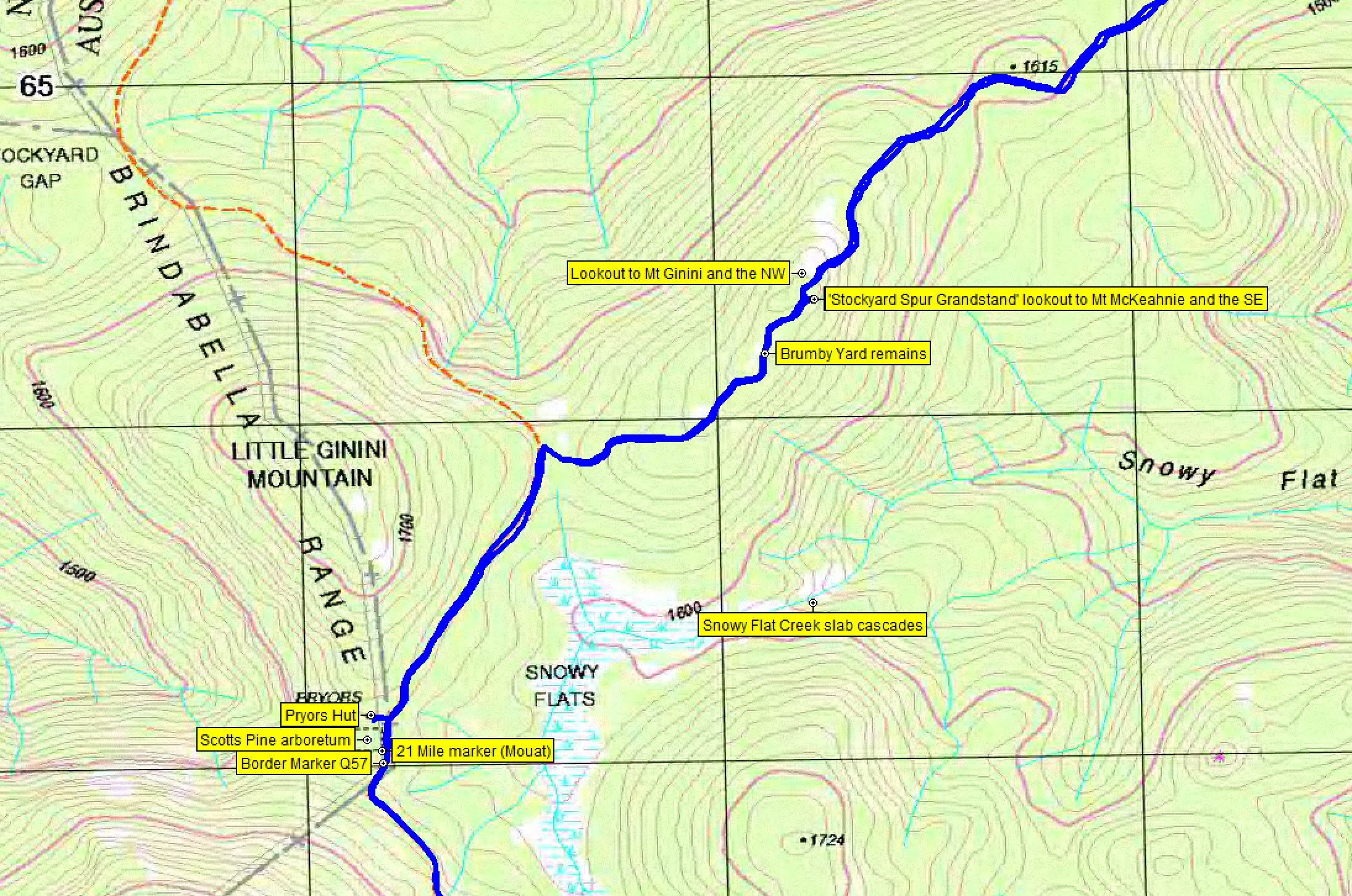
I called into the ‘Stockyard Spur Grandstand’, so named by Graeme Barrow some years ago. It provided great views to the east, particularly to Mt McKeahnie and ‘Dutchies Peak’ (follow the link to Dutchies Peak if you want to know how it was named).

View, including to Mt McKeahnie and ‘Dutchies Peak’, from Stockyard Spur Grandstand
Next port of call was the remnant Brumby Yard site. Not much left, just bits of wire.

Wire at the Brumby yard site
It’s downhill from there to meet the Mt Franklin Road (private vehicles can’t drive past the locked gate at the Mt Ginini car park). Then, according to the sign, 1km from here to Pryors Hut. I examined my stats again.

AllTrails stats at Pryors Hut
A couple of minutes to consume a hot (cold) cross bun.

Pryors Hut
I’d already passed (or been passed by) 3 runners and 4 walkers. At the hut were 2 more walkers and a cyclist in from Mt Ginini.
The Scotts Pine aboretum is next to Pryors Hut. The pines were planted in the 1950s by members of the Snowy Mountains Authority Landscape Section.

Scotts Pine arboretum
Just past the old horse paddock, off the road a metre or so, is the ACT border 21 mile marker. That’s 21 miles from Mt Coree.

21 Mile marker
And a couple of metres further on, the border marker Q57. The left hand arm of the lockspit points up to the next border marker on the northern nose of Mt Gingera.

Border marker Q57
Walking on from here you can see a number of hessian covers protecting the regenerating sphagnum on Snowy Flats.
Hessian protection over sphagnum on Snowy Flats
It’s around 1km from Pryors Hut to the Snowy Flat Creek culvert (gurgling away today) and the Mt Gingera track turnoff.

Mt Gingera Summit turnoff marker
Another track that has been fire-proofed with stone steps.

Stone steps on the fire-proofed Mt Gingera track
Some lovely colour in the daisies.

Trackside colour
There’s a track marker at the big bend.

Track marker at the bend in the Mt Gingera track
The track rises another 190vm over the 1.2km to the top. At 1857m, Mt Gingera is the second highest hill in the ACT.

End of Mt Gingera Track
There were another 3 walkers at the top.
Good views south to Bimberi Peak from near the real Mt Gingera.

Bimberi Peak from near Mt Gingera
AllTrails stats at the objective were:

AllTrails stats at Mt Gingera
Once again, the OpenStreetMaps used by AllTrails is a little out. If you’re interested in a discussion of where the real Mt Gingera is, have a look here.
I then went the few tens of metres south to the guyed pole, which has shrunk a little over the years.

Guyed pole reduced in height
Lovely views to the NE, including Tidbinbilla Mountain on the Tidbinbilla Range.

View NE from near Mt Gingera
Ate a second cold hot cross bun.
All that remained was to return the way I came. I didn’t go north along the Gingera top, as I’ll be back (from the Ginini car park) and do that next Saturday. But it’s not all down hill, as you can see from the elevation gain at Mt Gingera (1004vm) and at the end (1136vm).
The turn off Mt Franklin Rd told me how far to go.

Signage at intersection of Mt Franklin Rd and Stockyard Spur track
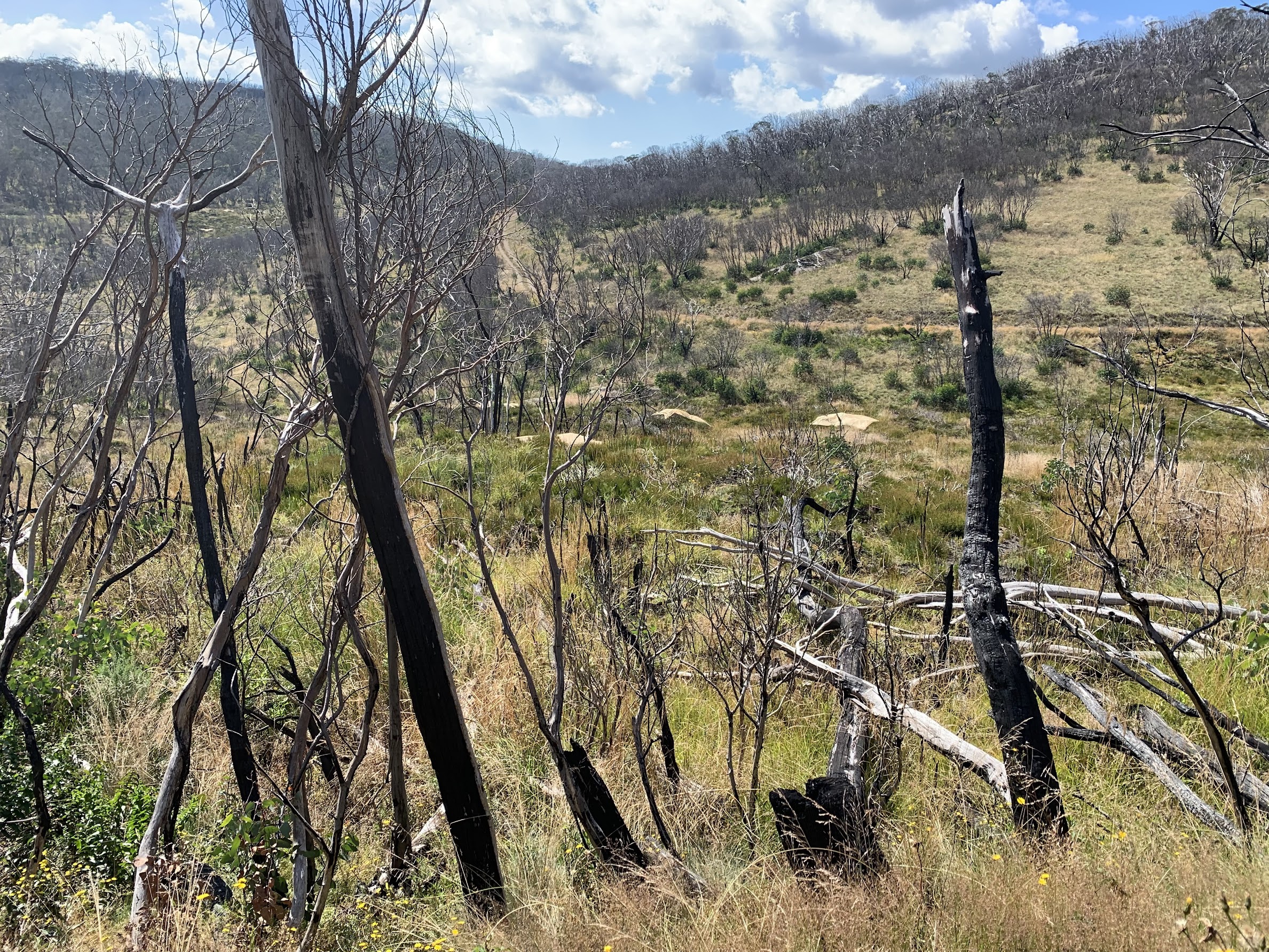
A few hundred metres later, I heard my name called from the bush. The only time my orange fluro t-shirt has proved useful. It was 2 great friends coming back up from the Snowy Flat Creek slab cascades. They had recognised me from 40m away. We walked along together and chatted until the Stockyard Spur Grandstand. They called in there again and I pressed on, just taking a photo of the NW lookout and Mt Ginini.

Mt Ginini and the NW lookout
There were some nice late flowers during the day.

Colour beside the track
A copperhead snake on the descent to Corin Dam.

Copperhead (not Tiger) snake descending to Corin Dam
Lyrebirds singing in the bush. My legs did not enjoy the descent, but it was better than the ascent.
Corin Dam finally appeared.

Glimpses of Corin Dam on descent
Corin Dam was overflowing noisily.

Corin Dam overflowing
Track Maps
The AllTrails recorded track map is here, where you can pan and zoom. And here’s the track laid out on my old TopoView 2006 map segment.

Track overview Mt Gingera from Corin Dam

Track 1 Mt Gingera from Corin Dam
Track 2 Mt Gingera from Corin Dam

Track 3 Mt Gingera from Corin Dam
Party
Just moi.
Janice
21 March , 2022 7:23 amWell done John. It’s so nice to see your emails pop up in my inbox again, and the great strides you have made in your recovery.
Johnny Boy
21 March , 2022 8:31 amHi Janice. Thanks for your encouragement. I’m still pretty sore this morning. Cheers. john
Greg Hutchison
21 March , 2022 10:25 amHi again John. Gee whizz your walking a lot. Sounds like another solo effort. I did the exact same trip several years ago based on your earlier trips. I found that climb from the dam quite tuff and coming down my knees were killing me. Interesting about the cascades on Snowy Flat. PS that snake picture is a Copperhead for sure. You can just see a bit of the yellow/creamy stripe they have under their belly. I was told a dozen years ago that there were no tiger snakes at altitudes over 1000 metres by some rangers near Orroral Ridge. Recently discovered that people have seen some tigers around Mt Kosi, also on Hannells Spur and I saw one on Cascade Trail but close to Dead Horse Gap Car park. Rangers have also told me that they have been seen along Happy Jacks River and near Seaman’s hut. By the way the text darkness on your comments box and Heading of the post is very feint. Would be nice to make it darker. Hope its not my eyesight or my computer.
Johnny Boy
21 March , 2022 11:29 amHi Greg. Thanks for the snake id. I usually keep a healthy distance from them and named this one via Google. I’ll correct it. The text attributes are set by the WordPress Creativo theme I use, so I don’t think I can change the darkness. Keep walking! Love your Mt Ainslie tracks, will be using some tomorrow. Cheers. john
Barrie
21 March , 2022 2:42 pmJohn, several years ago (7-10?) I trod on a fat Tiger not far short of the Grandstand when walking with two others. About 10 days ago, walking solo, returning to Corin from summit of Gingera somewhere between Grandstand and helipad but closer to Grandstand something black with narrow bright yellow bands caught my eye. I was curious as to what it could be. It was lying still and straight across the track some distance ahead of me. I never thought it might be a snake. As I approached it never moved. Up close, I realised that it was a snake the head distorted by a lizard half into its mouth. As i watched it slowly moved BACKWARDS. It fitted perfectly some of the photographic descriptions of tigers on google. I noted this sighting on a recent public FB post. No photo as I was too curious about the snake.
Johnny Boy
21 March , 2022 2:47 pmHi Barrie. How great to hear from you! I think I saw your recent solo trip on FB and it was that that inspired me to have a go. Cheers. john
Barrie
21 March , 2022 3:12 pmHi again, John. I am not a snake expert by any means, but I wonder if you might get an ID on your snake from CNM? Just from the numerous pics on google of both Tigers and Copperheads, I think it is more likely that the one in your pic is of a Tiger. To me, it does not have a creamy belly but yellow spots which are the beginnings of stripes . Tigers can vary widely in appearance. As I say, I am no snake expert .
Johnny Boy
21 March , 2022 3:25 pmThanks for the suggestion Barrie. I’ll try them. Cheers. john
Lisa Bradley
21 March , 2022 3:16 pmHi John,
I was so happy to see this post. I found Stockyard Spur challenging ? so it’s great to see that you did it. Your well on the way to recovery. ?
Cheers,
Lisa
Johnny Boy
21 March , 2022 3:26 pmThanks Lisa. I appreciate your encouragement. We’ll go the easier way next Saturday. Cheers. john
Greg Hutchison
21 March , 2022 4:32 pmYes it must be the hardest trail in the ACT. There was one group years ago running up and own it a dozen times in a day training for Nepal or similar.
The snake picture I am pretty much 99% sure a Copperhead. Have seen them numerous times in Kosi NP and a few times in Namadgi. If you look carefully you can see traces of a yellowish band under its belly. They dont always expose their belly. They are the most numerous snake at the higher altitudes ie above 1000m+. But that being said several people have seen tiger snakes at high altitudes in recent years. Is this a precursor to climate change. Scary thought!. I have a pic of a tiger snake from 2019 around 500m up Cascade Trail from Dead Horse Gap if you want it John? It will clearly show you the difference. Those copperheads also vary from a graphite gray dull colour to a really shinney jet black colour.
Johnny Boy
21 March , 2022 5:27 pmSo the snake is settled as a copperhead. Very quick response from WillO via the Canberra Nature Map.
“A good record. This is a Highlands (Alpine) Copperhead (A. ramsayi). If you zoom in on the head you can see the distinctive white markings on the labial scales (large scales along upper jaw above mouth and below the eye) and the creamy coloured lower sides along body.”
Barrie
22 March , 2022 7:59 amThat was quick.! It is good to have CNM’s confirmation of Greg’s ID. It is interesting that for the CNB the deciding factors were the scales around the mouth.
Barrie
22 March , 2022 8:01 amoops! typo! in my last comment, for CNB please read CNM
Ash
22 March , 2022 1:22 pmJohn, just wondering what camera you are using … phone or real?
Really enjoyed this post and the snake chat. Thanks
Johnny Boy
22 March , 2022 2:32 pmHi Ash. Thanks for your positive feedback. It’s an iPhone XS Max. I’m just a snapper, so it suits me well. Wish I knew more about photo composition. Cheers. john
Greg Hutchison
22 March , 2022 2:54 pmWell Johnno your snapping dam well. Those photos were excellent as are all your latest. That Iphone XS is the middle model of the Iphone 13 series. I see you can now transfer photos from Iphone to Window PX easily. Did you get the 128GH, 256GH or 1TB of memory?. PS your WordPress Theme Creativo does allow you to alter the colours, sizes and other attributes of text and headings as far as I remember so you should be able to customise it to your hearts content. Must admit however there are so many options you can go mad trying to select the right one. I had to to give up the theme as it was crashing my site and reloading the theme options they started with. I just gave up and went to Astra maybe now Kadence theme and Elementor. WordPress is changing so much that you will soon be able to have a site just with WordPress Gutenberg and maybe customised blocks ie maybe Elementor Blocks
Johnny Boy
22 March , 2022 4:14 pmHi Greg. It’s an iPhone 10 with 512GB memory. Don’t think I’ll ever get that much again if I upgrade. Thanks for the heads up on theme options. I agree, just too many options to get my head around. Cheers. john