
Snow shoeing the Gingera Ridge | photo Greg Buckman
Thursday 18 July: Have a look at the snow on Mt Gingera – L/M. Book by Wednesday 2pm. Around 20km and 1200m climb. For robust walkers. Map: Corin Dam. Leader: John Evans 0417 436 877 john@johnevans.id.au . Transport: ~$10.
Further Information
What a difference a week or so can make. We were up around here on the nearby Little Ginini Mountain on 6 Jul 19.
Summary
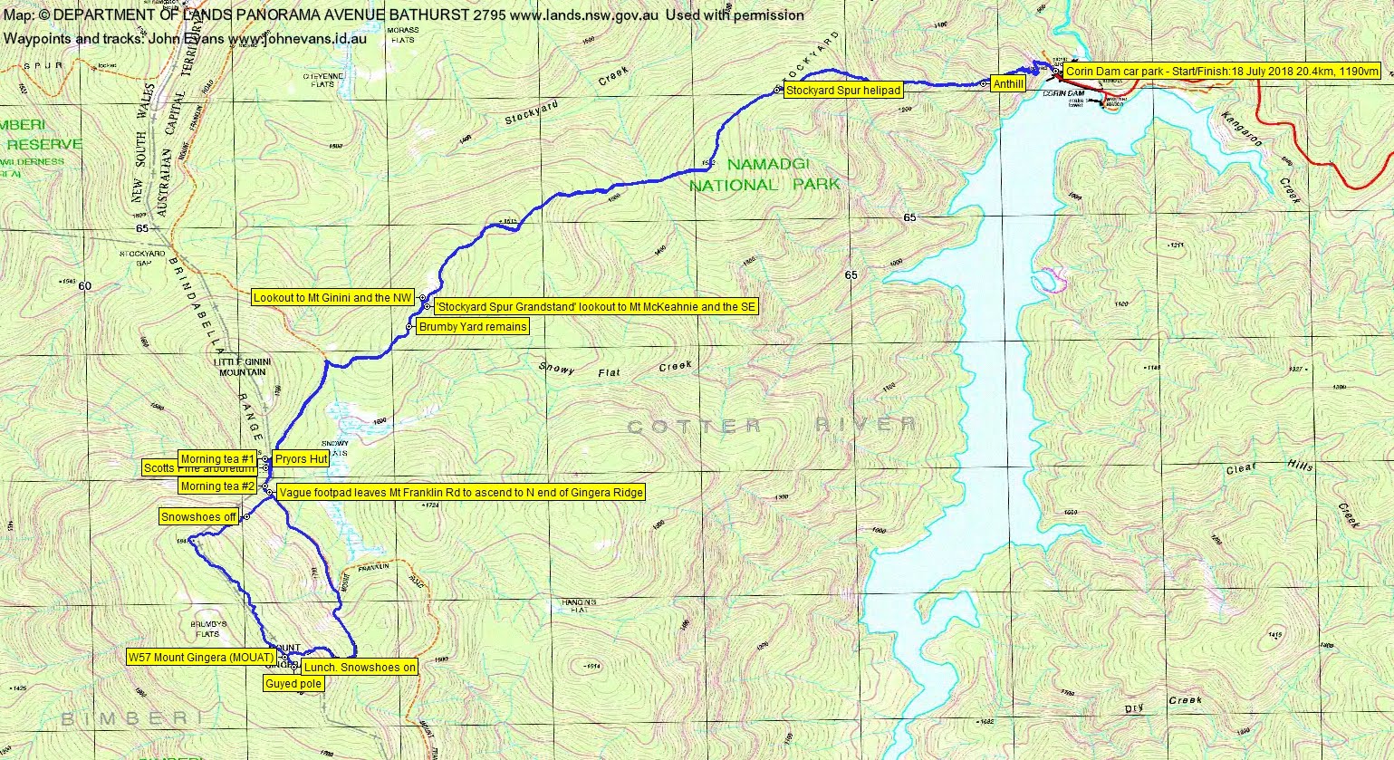
Distance: 20.4km | Climb: 1190m | Time: 7.40am – 4.40pm (9hrs), including 1hr 10mins mins of breaks | Grading: L/M-R; H(13)
Photographs
Photographs are available, where you can start a large sized slideshow.
Waypoint and Track Files
Download the gpx file for this trip (if your browser does not automatically download the file, it will open the gpx file in a new window and you can then save it). To use in Google Earth, do File, Open… and select Gps or All files as the File Type.
Track Notes
Driving into Corin Dam we spotted some snow on Stockyard Spur, so our hopes were high that our snowshoes would be useful.
The 2.3km up to the helipad on Stockyard Spur took 1hr 5mins today. A useful yardstick for my ageing body, that’s 15mins slower than my best time. Lyrebirds calling as we climbed.
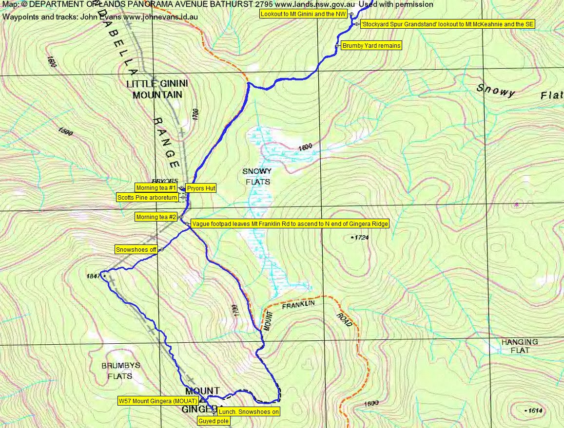
We ran into a few patches of snow, which got more frequent and deeper as we continued up Stockyard Spur. Called in at the eastern lookout for views to Mt Ginini, then down to join the Mt Franklin Rd. A further 1km to Pryors Hut for, as it turned out, morning tea #1. My bad, as one of our party took a phone call just before the hut and walked past. He turned around when he realised there were not two sets of prints in the snow and we regrouped. But he deserved morning tea, so we had #2.
The day had cleared to blue sky and there was plenty of snow as we climbed the footpad to Mt Gingera. Could have popped our shoes on, as the snow was knee deep towards the top, but needed a dry seat so we waited till lunch at the guyed pole.

John and John at the Gingera guyed pole | photo Greg Buckman
Every good trip has social media connection.

Always social media contact | photo Greg Buckman
This is what we’d come for and we enjoyed a magical snow shoe along the Gingera Ridge.

Passing Mt Gingera high point

Snowy trees on the Gingera Ridge

Snowshoeing the Gingera Ridge

The Gingera Ridge

Snowshoeing the Gingera Ridge
Pristine snow – no others had been this way before us recently, although there were several parties going to and fro to the hill during the day. A lone camper in the area at Pryors Hut.
Snow shoeing the Gingera Ridge | photo Greg Buckman

Snow shoeing the Gingera Ridge | photo Greg Buckman

We begin our descent to Pryors Hut
We reached the NW end of the ridge at SH1847 and were able to leave our shoes on for the descent until the 1720m contour.
Called in for a chat with the camper at Pryors Hut, then returned down to Corin Dam, via a stop at the lookout to Mt McKeahnie to the west.

John and John at the Graeme Barrow named Stockyard Spur Grandstand lookout east to Mt McKeahnie | photo Greg Buckman
The water level was noticeably lower than 6 July.

Corin Dam looking empty – if married, shower with your spouse
Greg produced the ABC TV news weather photo for the following evening, a great shot of snow covered trees with Bimberi Peak at the back!
Not a bad little trip, if I do say so. Thanks Greg and John for your company.
Track Maps
Track overview
Track 1

Track 2
Profile

Party
4 walkers – Mike B, Greg B, John G, me.
ian T
1 August , 2019 5:56 pmHi John
Nice pics / walk!
Do you mind sharing what brand – model of snow shoes you use?
Thanks
Ian
Johnny Boy
1 August , 2019 6:08 pmHi Ian. They are 14 year old ex-rental shoes. MSR brand. Quite long, so good support. Certainly not as flash as newer models, but they only get a few uses each year. Cheers. john