
Correa ‘Canberra Bells’ above the Murrumbidgee River
Thursday 20 June: Uriarra Pine Forest Caching and other nearby places – L/R. Caching around Sherwood, down the lower Cotter River, behind Uriarra Village and near the Murrumbidgee River near the Cotter. Leader: Roger E.
Summary
Distance: 20.9km | Climb: 760m | Time: 8.00am – 3.35pm (7hrs 35mins), including driving and caching time | Grading: L/E,R; H(12)
Photographs
Photographs are available, where you can start a large sized slideshow.
Video
Waypoint and Track Files
Download the gpx file for this trip (if your browser does not automatically download the file, it will open the gpx file in a new window and you can then save it). To use in Google Earth, do File, Open… and select Gps or All files as the File Type.
Track Notes
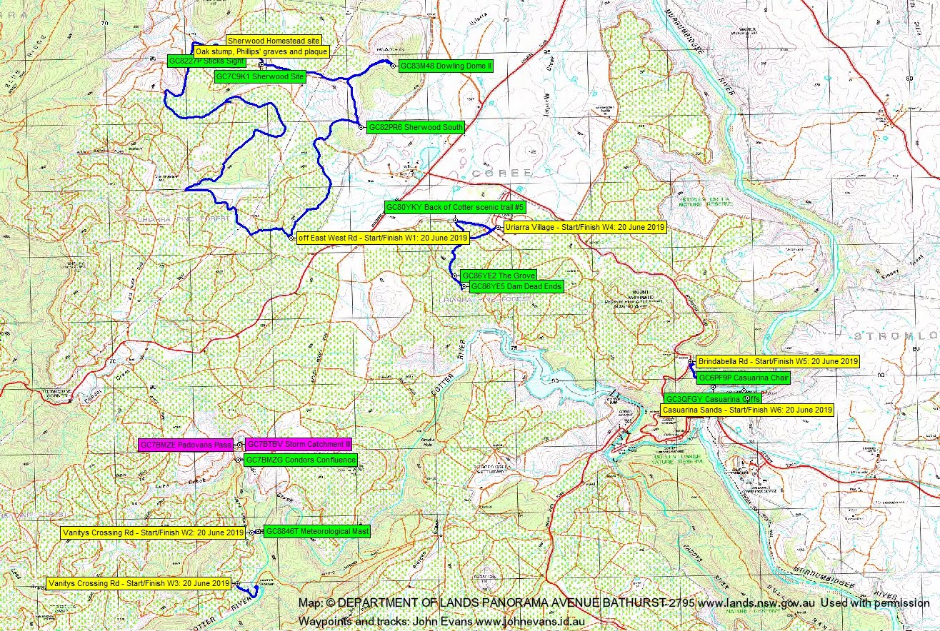
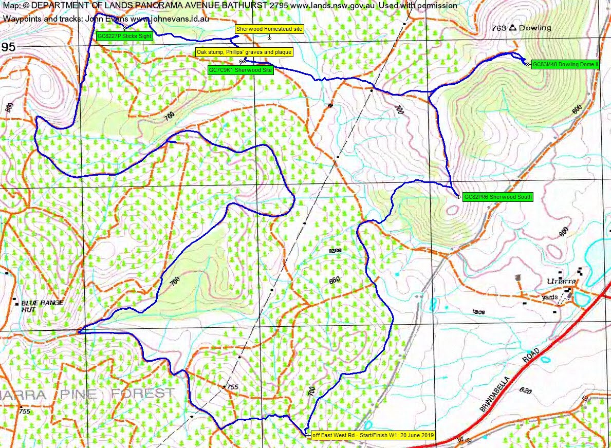
We met in Weston Creek at 7.30am. It was cold. We drove Cotter, Brindabella Rd, right onto East West Rd and a couple of hundred metres up a side fire trail to a locked gate. Looks like here is the start of the Sherwood Walk (a lot more sensible than starting at Blue Range Hut where I normally do).
Walk 1
It was cold walking on fire trails in the shaded pine forest! 1.8km north-ish we went off-track and climbed to a knoll south of Mt Dowling and overlooking Uriarra Station.

A sharp frost to start the day in the Uriarra Pine Forest
Here we logged GC82PR6 Sherwood South. A wonderful view in the crisp air.

View from a knoll up behind Uriarra Station
Check out the video too.
Then north and NE to a spur running SE off Mt Dowling to find GC83M48 Dowling Dome II.
Next, SW and west off-track to the Phillips graves and plaque above the Sherwood Homestead site.

Grave marker near the Sherwood site
Here I logged GC7C9K1 Sherwood Site.
Great to see a new Oak tree planted by the stump of the old one burnt in 2003.

A new oak tree has been planted at the grave site near Sherwood
The next leg took us generally west on a footpad to find geocache GC8227P Sticks Sight, south of Two Sticks Hill.
We could have returned the way we came, but a loop is better than a there and back (just in this case) and we pounded the fire trails and a bit of footpad for 1hr 50mins and 7.5km back to the car. My contribution was to suggest an off-track short cut near the car – horrible blackberries.
We drove the short distance back to Brindabella Rd.
Walks 2 and 3
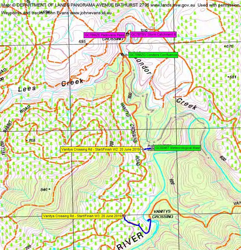
We drove south down Bullock Paddock Rd, stopping at Padovans Crossing to pick up some information for geocache GC7BTBV Storm Catchment III and me scoring a DNF on GC7BMZE Padovans Pass. A win at the next culvert with more information for the multi GC7BTBV Storm Catchment III and a find of GC7BMZG Condors Confluence. A pretty spot where the creeks meet.

Confluence of Lees and Condor Creeks
A further kilometre or so we stopped and walked in to log GC8846T Meteorological Mast. How on earth does the cache owner find these places?

Structures at GC8846T Meteorological Mast
Another kilometre of driving and we stopped to walk in to Vanitys Crossing with its great fish race.

Vanitys Crossing and fish slide
I crossed in bare feet. It was cold.

Crossing Vanitys Crossing
Back up to the car and drove out and into Uriarra Village.
Walk 4
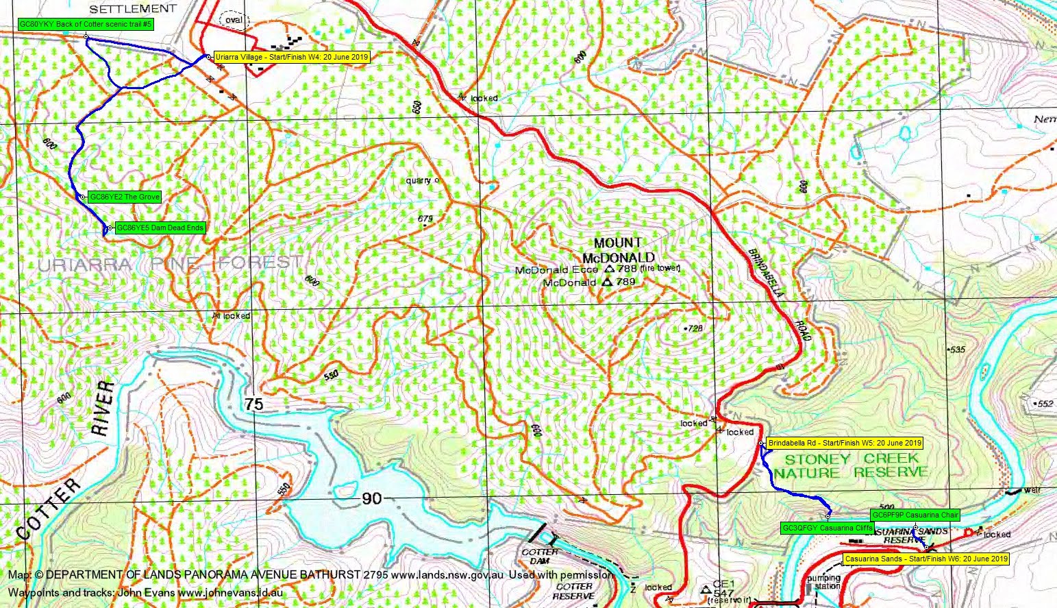
From the back of Uriarra Village we followed a fire trail west for me to log GC80YKY Back of Cotter scenic trail #5.
Then onto a disused fire trail down towards an arm of the new Cotter Dam (my old 2006 digital maps don’t show the new extent of the dam).

Cotter Dam from south of Uriarra Village
A log of geocaches GC86YE2 The Grove in a grove of poplars and GC86YE5 Dam Dead Ends down near the high water line.

An arm of Cotter Dam from south of Uriarra Village
Walked back up to the car. Drove to near the Cotter Dam, just down Brindabella Rd from where all teh burnout rubber is on the road.
Walk 5
We found ourselves at an entrance into the Stony Creek Nature Reserve and headed down a GPSr map-marked track towards the Murrumbidgee River. Our objective was a cache that Roger had previously not been able to reach from below. Easy going at first, then a final slow and steady to the edge of the cliff top to log GC3QFGY Casuarina Cliffs. Great view down to the river.

View down to the Murrumbidgee River from geocache GC3QFGY Casuarina Cliffs
Returned to the car. Drove to Casuarina Sands.
Walk 6
Roger sat in the car whilst I logged GC6PF9P Casuarina Chair which was off-line last week.
Great day. 11 caches for me and some great locations and views. Thanks Roger; we’ll do it again
Track Maps
Track overview
Track W1
Tracks W2 and W3
Tracks W4, W5 and W6
Party
2 walkers – Roger E (Marmaduke Rothschild) (leader), me (JohnnyBoyACT).