
Happy come-and-try-it walkers

Fun in the boulder crack for little and big kids alike
Saturday 15 June: CBC’s second, fun come-and-try-it bushwalk – Orroral Valley – M/M. Latest news: We now have a short 4km loop led by Shell, suitable for any age child; a medium 6km loop led by Lisa; and an 8km loop. Want to try bushwalking? You are very welcome to join us on a circuit in the Orroral Valley, suitable for beginners who are fit enough to keep walking for 4 hours at a moderate pace and active families with children aged 10 and up. The walk begins at the site of the Orroral Tracking Station (toilet there), crosses the Orroral River via a bridge and visits a huge boulder thought to be an indigenous site. We then continue off-track through undulating and open woodland, following the Orroral River upstream under the forested ‘Orroral Ridge of Stone’ with views up to its wonderful boulders and tors. After lunch we will find a place to cross the river, then return down the open grasslands of the valley on the western side. It will be cold, so wear warm clothes, a warm hat, optionally a neck warmer and gloves, a raincoat even if the forecast is fine, your morning tea and lunch and water, and wear warm socks and closed-toed shoes with good grip. Carry your gear in a back-pack. Club members are welcome too. No need to book. Please contact the organiser on 0417 436 877 if you have any questions. Terrain: open grasslands, fire trail, off-track through open woodland with small patches of scrub, rock-hop (with assistance if needed) across the river. Transport: Drive yourself to the Orroral Tracking Station carpark at the end of Orroral Road (Google Maps knows where ‘Former Orroral Valley Tracking Station’ is). All sealed road, around 35km and 40mins from southern Canberra suburbs; be very careful of kangaroos and other wildlife. Please be at the meeting point ready to start walking at 9.30 am. The leader will be at the meeting point whatever the weather. Contact the leader by the previous Thursday if you would prefer to share transport. Maps: Rendezvous Creek and Corin Dam. Leader: John Evans 0417 436 877 john@johnevans.id.au .
Summary
Full loop Distance: 6.7km | Climb: 100m | Time: 10.00am – 1.15pm (3hrs 15mins), including 45 mins of breaks | Grading: S/E-M; E(7)
Photographs
Photographs are available, where you can start a large sized slideshow.
Waypoint and Track Files
Download the gpx file for this trip (if your browser does not automatically download the file, it will open the gpx file in a new window and you can then save it). To use in Google Earth, do File, Open… and select Gps or All files as the File Type.
Track Notes
Saturday dawned foggy in central and northern Canberra, but down in Tuggers the sun was out early to melt the frost. It turned out to be a perfect early Winter’s day in the ACT – blue sky, little cloud and just a zepher of a breeze.
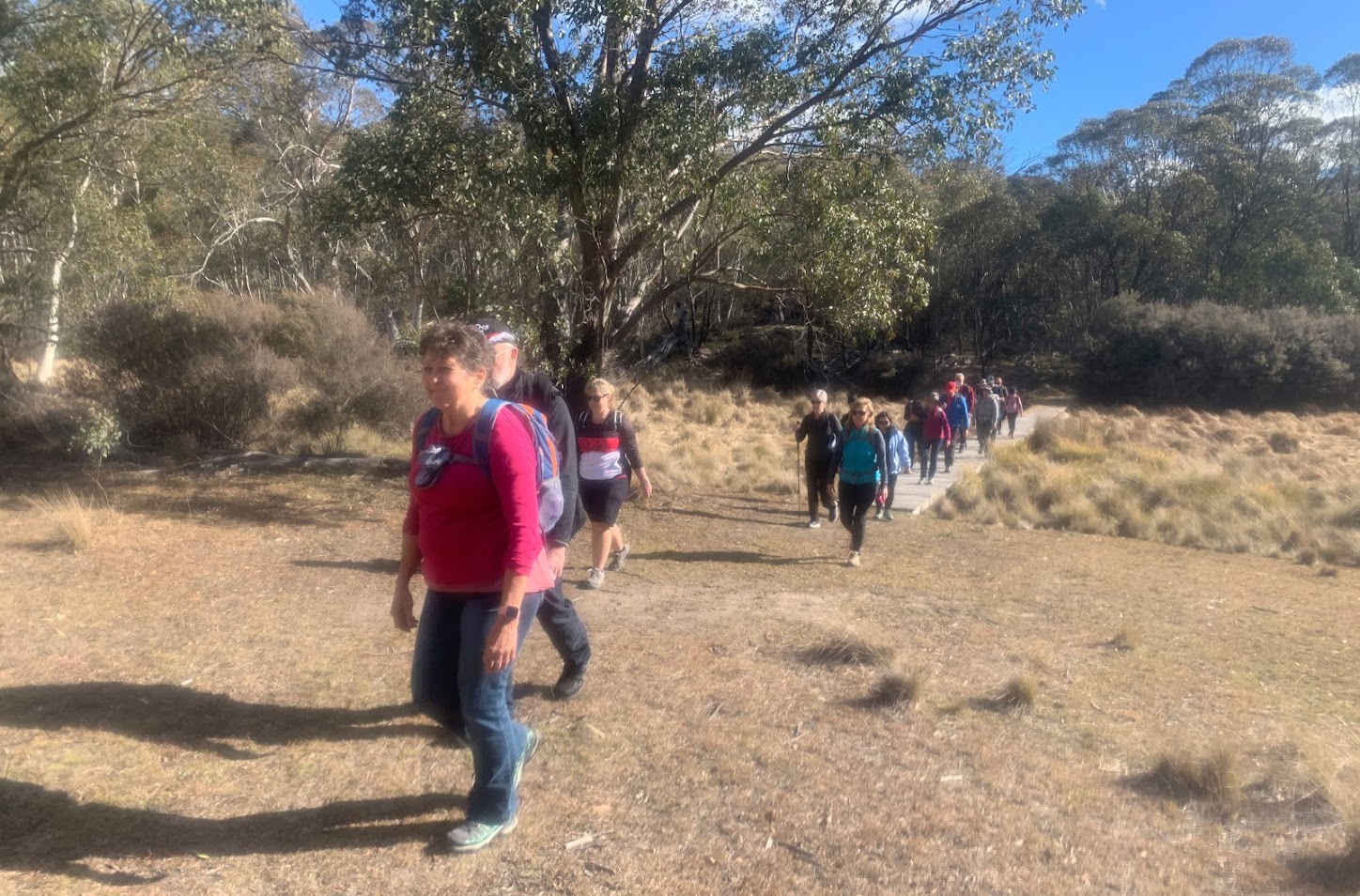
The Orroral Tracking Station car park soon filled and 30 come-and-try-it walkers signed on. 25 visitors and 5 Canberra Bushwalking Club members. The pre-walk briefing included a light touch on the geography and cultural significance (both indigenous and European) of the area, as well as an outline of the 3 walks on offer. At last we were ready to walk.
Ready to walk
We tracked through the site – where else can you start a bushwalk on a sealed road and concrete footpath? At last we had grass under our feet and were out with the roos. A pleasant stroll to the north-west, well up from the reedy bog of the Orroral River.

Walking between the Orroral Tracking Station and Orroral River bridge
We turned right onto the Link Track (part of the Australian Alps Walking Track, a 640km, 6 week walk from Victoria through the Australian high counrty to finish at the Namadgi Visitors Centre), then across the Orroral River bridge and walked up to a huge granite boulder.

Heading up towards the boulder after crossing the Orroral River bridge
Most of us enjoyed a squeeze through the cracks in the boulder. The central passage has a large drop in it, but a narrow side passage provides a through route. It was dark inside, but easy to see in the phone light.

Fun in the boulder crack for little and big kids alike

Dark in the absence of phone light

Now we can see

In the narrow slot
Here, Shell and another family group with a 5 year old readied to return. But we think they had another lap or two through the crack before heading back.
The rest of us continued on through lightly timbered eucalypt woodland, generally paralleling the river. At times we followed an old farm track, sometimes animal pads most likely made by wombats. Nice views up to the ‘Orroral Ridge of Stone’ and its granite tors, ‘The Belry’ prominent.
Morning tea in a patch of sun.
Eventually we dropped down to the river where there was an opportunity to cross and return. Lisa accompanied a walker on the remainder of the medium loop, preferring to take off their boots to cross the river. It was cold!
Those wanting a longer walk (or perhaps not wanting wet feet) continued on. The going opened up a bit.

Open going between the two river crossing points
At last there was no option other than to cross.

Last chance to cross the Orroral River
A variety of techniques used, including boots off and agile jumps. No ‘sploosh’, so everyone succeeded.
The true right side of the river is more open. We walked up to the Rowleys Orroral Valley Hut site and had lunch.
From here, it was south-east back down the river valley, following the mown AAWT. A boardwalk took us across the marshy James Creek.
The deciduous trees of the Tracking Station site guided us back to the start, sharing the open country with grazing kangaroos.
We do hope that everyone enjoyed the sights, sounds and smells of the Orroral Valley. Plenty of other walks around here, so do come back to this lovely, peaceful place.
Huge thanks to Shell and Lisa for leading the short and medium loops.
If you’d like to join the Canberra Bushwalking Club, do so via the Login page and use the ‘Not registered yet? How to join’ function. There are some help files if you need them.
Visitors are very welcome to come on up to 3 walks before we lean on you to join. Just choose a walk which interests you and is within you current walking ability from the publicly accessible Current Activities list and submit a booking request. Contact the leader if in any doubt.
I very much enjoyed meeting everyone and walking with you. I hope to see you in the bush again soon!
Track Map

Where we went

Google Earth snip
Party
30 walkers.