… with guest blogger Lauren O and guest recorder Stephen M

Identify the crazy trig climber
Saturday 2 June: Molonglo Ridge – L/M. Many have driven Woolcara Lane to walk in the Yanununbeyan Reserve, but not so many would have walked on the Woolcara property. A unique opportunity to walk the rolling hills of the Molonglo Ridge, from Mt Molonglo to Yarrow Pic. Around 18km and 400m climb. Open farmland walking. Map: Hoskinstown. Leader: John Evans 0417 436 877 john@johnevans.id.au . Transport: ∼$10 per person. Limit: 12.
Further Information
I was last here 29 Nov 14 and 31 Jan 12.
This trip was on private property. You need the owner’s permission (which we had) to walk here.
Summary
Distance: 18.9km | Climb: 700m | Time: 8.30am – 2.10pm (5hrs 40mins), including 40 mins of breaks | Grading: L/M; H(12-)
Thanks to Stephen M for the day’s gpx file from which these stats were derived. Interestingly, without reviewing previous trip reports, I graded this the same as the two previous trips (distance = 4; climb = 5; terrain = 3. So BBC grade = H(12), but it wasn’t that hard, so H(12-).
Photographs
Photographs are available, where you can start a large sized slideshow.
Videos
Waypoint and Track Files
Download the gpx file for this trip (if your browser does not automatically download the file, it will open the gpx file in a new window and you can then save it). To use in Google Earth, do File, Open… and select Gps or All files as the File Type.
Track Notes
Thanks to friends with (land) benefits, John was able to get access to a beautiful property just outside of Queanbeyan known as Woolcara. We met at Q-town for an 8am start, ready for a day of rolling hills across open farmland. This made an interesting change from the usual bush-bashing/granite scrambling/shin busting/bruise sustaining weekend adventures of late (I love those kind of hikes too!)
You know you are in for a cold day when John wears long pants. We barely recognised him out of his usual shorts, but the fluoro socks gave him away. Linda had a brilliant bag of head warming accessories to share, and once we had gloves and beanies on, our group of 13 suckers walkers were off on our 18km day. Thanks to leaders like John, we can just switch our brains off and blindly follow along, without having to worry about navigation. You can then truly appreciate the landscape and just soak up the view. I definitely prefer this to meditation or yoga!
Huge flocks of galahs and cockatoos greeted us, and there were plenty of sheep about. John promised a fair bit of up and down over the hills, but after the first half hour I was beginning to wonder if the downhill was just a myth, as my lungs were struggling a bit against a steep-ish climb and a biting wind.

Threatening weather at the start of the walk | photo Lauren Ogden
After about an hour and a half we arrived at the top of Mount Molonglo, to spectacular views across farmland on one side, and Googong on the other. We could just find Black Mountain tower in the distance, with the Captain Cook Memorial fountain looking a little lopsided thanks to the wind. Having recently completed visits to all of the beaconed trigs in the ACT, I do enjoy the occasional NSW trig, so was a nice surprise to find one at the top. They are not nearly as much fun as the traditional Canberran quadripods which seem like jungle gyms for grownups, but they do have a certain charm. There was bit of egging on about starting a new list to visit all the NSW trigs, but I held my ground. No more lists for a while! I had concerns that this trig wouldn’t support my body weight, but enjoyed watching Linda climb up, doing a great impersonation of Kate Winslet on the edge of the Titanic (‘I’m flying Jack!’)

Mt Molonglo trig | photo Lauren Ogden
It was too chilly to stop at the top for morning tea, so we found a lightly wooded area for a break. As we set off again for peak number 2 of the day, the weather was looking a bit threatening. The rain that we could see over the NSW side was quickly coming closer. Thankfully, it seemed to skirt around us and we avoided getting wet.
It was about another 1.5 hours to the top of Yarrow Pic, with the second steep ascent of the day. The land was quite thick with thistles in parts, and the chatter seemed unanimous that we were grateful not to be doing this walk in the heat of summer with long grass, snakes and no shade.

Sad looking tree on the way to Yarrow Pic | photo Lauren Ogden

Beautiful rolling hills | photo Lauren Ogden
We could see another little trig at the top of Yarrow Pic, which kept us on course (unlike our trip to Castle Hill last weekend where the trig was completely obscured by fog.) Looking a little stronger thanks to some concrete assistance, I felt a bit more confident scaling up this trig for a great 360 degree view of the Molonglo ridge and beyond. There was a weird pole/metal structure on the top, which had replaced the pole and metal disc now lying unceremoniously on the ground. RIP dear old trig pole.

RIP trig pole | photo Lauren Ogden

Yarrow pic trig | photo Sophie L
There were a couple of eagles flying overhead, adding to some very diverse birdlife on the property. With lungs and bums feeling the strain by the time we got to the top, we felt entitled to a nice leisurely lunch. Some great chatter with a really diverse group of people, from Australia, New Zealand and France. A great range of ages from never-too-young to never-too-old.
I think John was ready for a post-lunch nap, but most of the group were on their feet ready to head back down out of the cold. He wasn’t going to win this battle, so off we went once again. We took a slightly different route back, wandering through what felt like a sheep graveyard in parts.

Following the sheep back home (the ones that were alive anyway…) | photo Lauren Ogden
The walk involved navigation of quite a few fences. I am always interested in the varying strategies for fence hopping. Having short legs myself I prefer sliding under, while being slightly envious of those with longer legs who can just step over them. I was also shown some commando rolling techniques today which were quite impressive.
Spotting a rainbow in the distance, I think our pace picked up as we raced each other to the pot of gold. Although we never quite got there, we were soon enough surrounded by the familiar sights and sounds of the galahs and cockatoos which signalled the end of the walk. By this time there were also a lot of horses about saying hello. Some were in stylish coats, others looked mortified that they had to wear undignified hoodies. No judgement from us in our mish-mash of cold weather gear!

Following the rainbow | photo Lauren Ogden
It can be so easy to stay at home rugged up on cold days this like, so big thanks to John for encouraging us to get off the couch for around 5 and a half hours of gallivanting around the country side. Sophie’s Fitbit recorded 19.77 kms, so I think that entitles me to a cider tonight.

Some interesting buildings on the property. Peter thought these might have been part of an old abattoir | photo Lauren Ogden
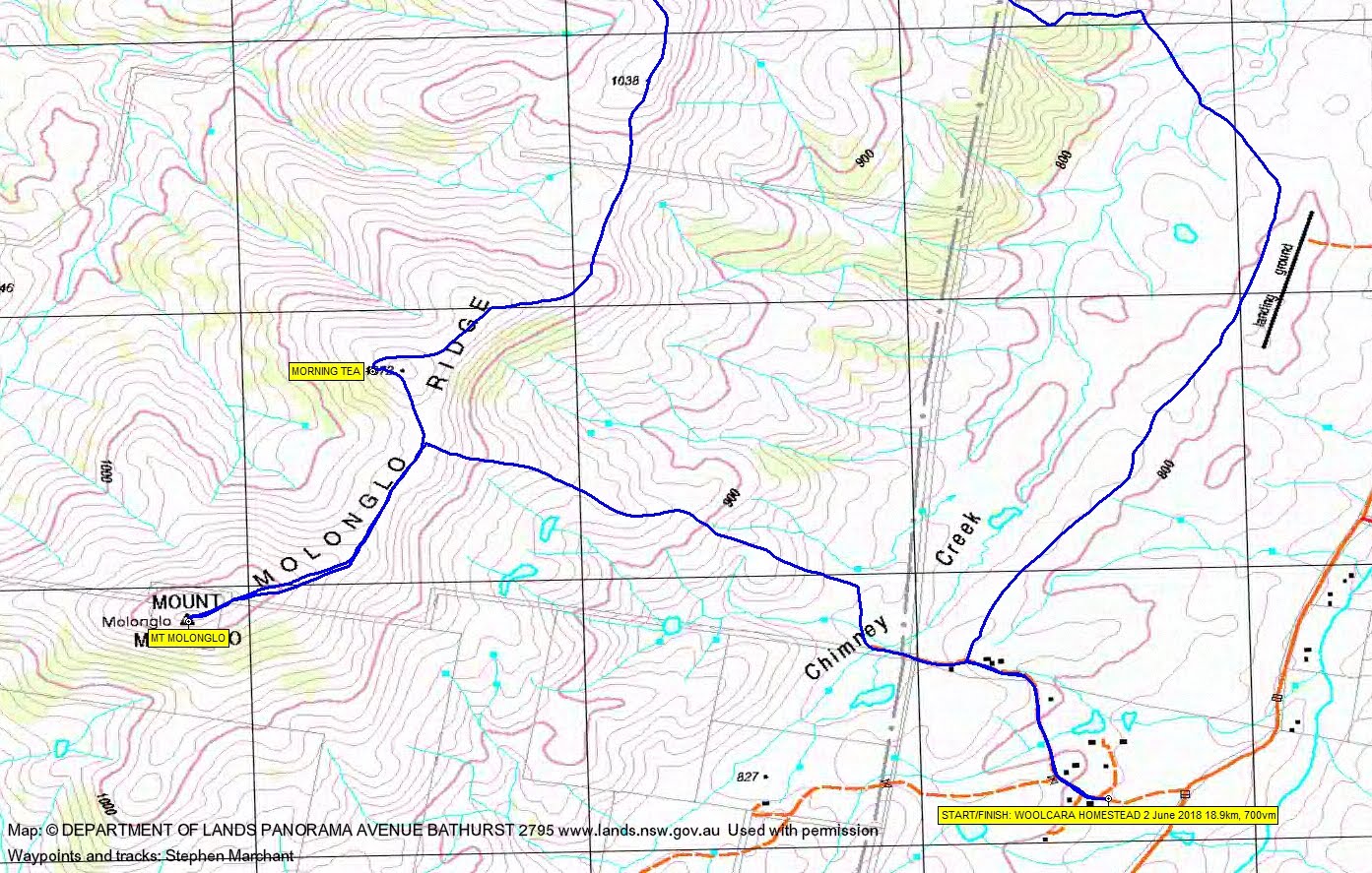
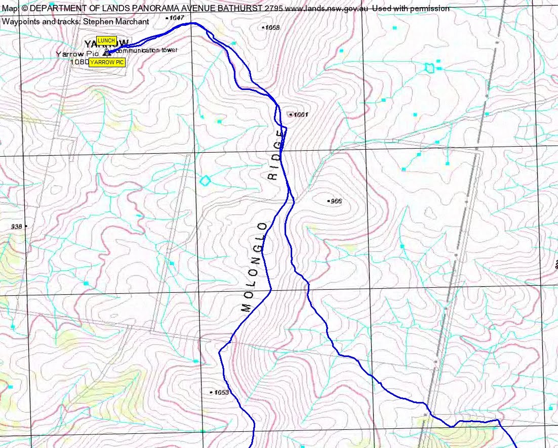
Track Maps
Track overview

Track overview
Party
13 walkers – Helen A, Peter C, Isaac de R, Michael de R, Chris F, Denis G, Linda G, Sophie L, Stephen M, Lauren O, Amelie R, Jacqui R, me.