Saturday 19 November 2022: The Pimple ! – L/E-M,ptX. In via Snowy Corner and Tidbinbilla Mountain, out via either SE from Tidbinbilla Peak or via Johns Peak. Good friends Ian (the granite hunter) and Rob coming to hold my hand.
Summary
From Garmin Connect – Distance: 11.54km | Climb: 1042m | Time: 3:40 moving + 3:09 of stops = 6:49 | Grading: L/E-M-H,ptX; H(12).
Photographs Photographs are available here.
gpx File The gpx file is available here.
Track Notes
It’s been 8 years since I did this trip, last on The Pimple on 30 Sep 14. I did a couple of solo recces so as not to completely embarrass myself – up to Snowy Corner and to Tidbinbilla Mountain on 26 Oct 22 and down the SE exit from near Tidbinbilla Peak on 16 Nov 22. I still completely embarrassed myself.
We were through the TNR early opening gates at 7:30am, parked at the Mountain Creek car park and were walking up the link track to the Lyrebird Track by 7.45am.
Lovely water in the Mountain Creek feeders.

Feeders to Mountain Creek flowing strongly
Nothing to say about the trip up to Snowy Corner – I couldn’t! I haven’t walked with my good friend Ian for 3 years and I’m sure he thought I was going to die. Having walked with my good friend Rob as recently as a week ago, he hopefully knew I wouldn’t.
Views from the seats today as the lowering cloud we observed driving in to TNR was lifting.

View from the 2 seats around half way up to Snowy Corner
The leg from Mountain Creek car park, along the Lyrebird Track and up to the crest at the Snowy Corner cairns was 2.5km in 1:40.
The next leg from Snowy Corner cairns to Tidbinbilla Mountain was 1km in 40mins.

Ian looks back to see if I’m still alive, open area on way to Tidbinbilla Mountain
Views to Corin Dam as we negotiated the final climb, and from the top.
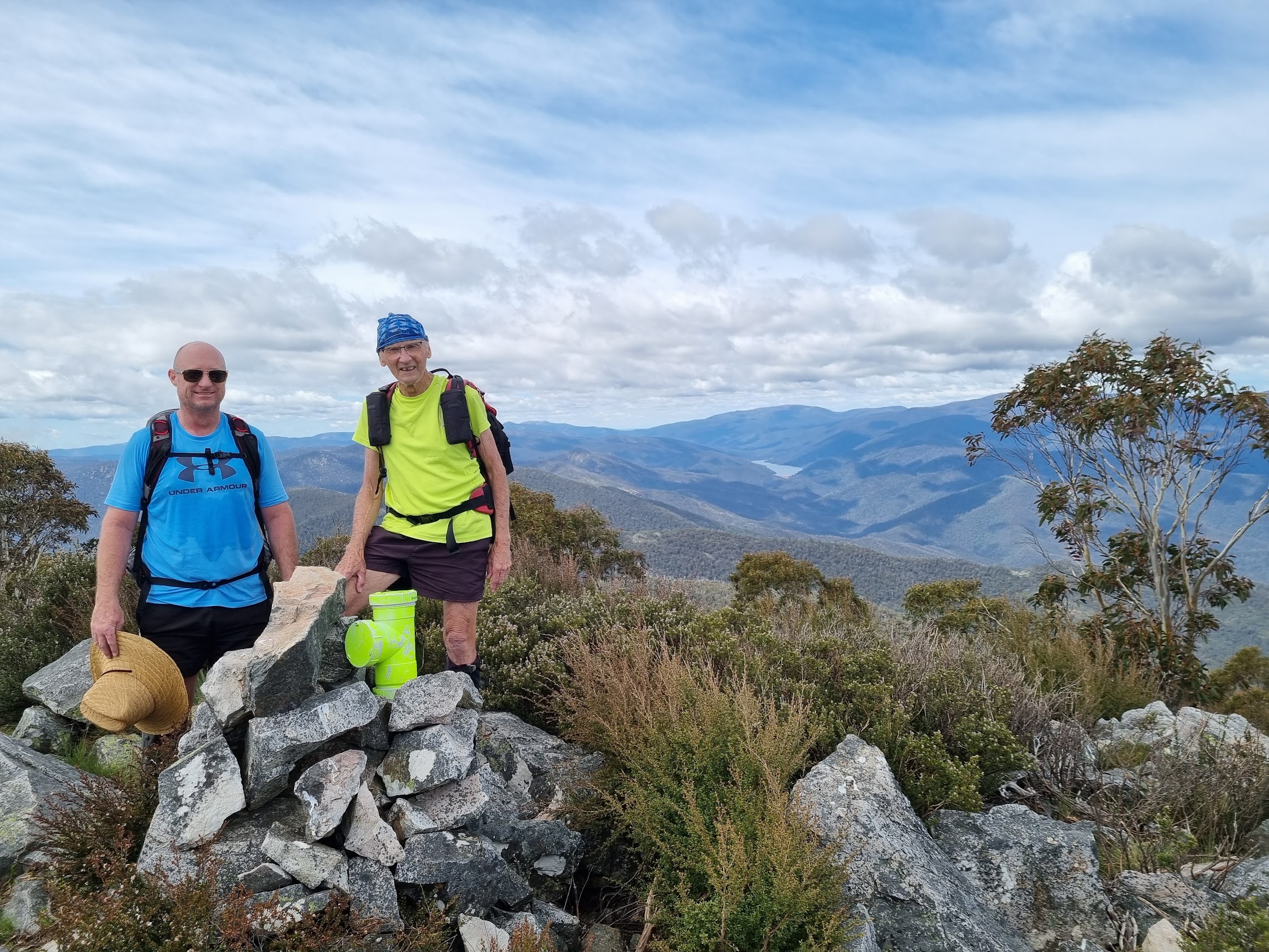
Tidbinbilla Mountain, Australian Capital Territory, Robert McLeod, John Evans | photo Ian Wright
We sat down for smoko towards the northern end of the top.
We had a view along the crest of the Tidbinbilla Range.

The crest along to Tidbinbilla Peak from Tidbinbilla Mountain
I hadn’t done the next leg on my recent recces and, from memory, was looking forward to it. After a bit of a rocky, scrubby descent to the north, the route opens out onto a more gentle slope down to a saddle.

Lovely going after the drop off from Tidbinbilla Mountain
We were soon on a footpad, a little braided and vague in places, heading toward the turn off to The Pimple.

On footpad NE of Tidbinbilla Mountain
A couple of more photos of the footpad in the photo album.
The ‘Cairn marking turnoff to The Pimple’ marked the end of this leg, 730m in 21mins.

‘Cairn marking turnoff to The Pimple’
Next was our there and back to The Pimple. I’d heard that this route was a very well defined footpad, perhaps even to the standard of the SE exit from near Tidbinbilla Peak. Thankfully, the route wasn’t as decimated as that. Mainly a footpad made with feet, a couple of cairns and just one or two hip high sapling cut offs. I was leading at the start of the descent and probably took an incorrect braid down the NE side of the ‘Rocky spine’.
The footpad descends to the base of The Pimple. Strangely, there are very few views of the objective.

First view of The Pimple
There are quite a few photos of the footpad in the photo album, as it certainly wasn’t there 8 years ago.

Footpad to The Pimple at 1450m contour
We bottomed out at the 1410m contour and began the final climb.

Beginning the climb to The Pimple
A rocky route.

Climbing to The Pimple
Reached the top at 11.27am. The leg down and up 1km in 40mins.
Spectacular views!

View from The Pimple

Scree dribbles NW of The Pimple

Razor spurs running down from Johns Peak and Camels Hump from The Pimple
We drank in the views for some time, but too early for lunch.
I was reluctant to turn about, feeling a bit sad that I’d never return. Still, that’s life. Retracing, our descent was a little less hairy (but scrubbier) than the ascent. I remember doing exactly the same thing on the previous trip. Then the long pull back up the footpad, me trailing in the rear. A better route round the rocky spur near the top by going round the SW flank. 1km in 1 hour.
I called a long lunch. Jared H and a mate walked by, heading for Tidbinbilla Peak.
Set out again at 12.50pm on the next bound to just south of Tidbinbilla Peak. Again, a footpad, a little vague in places. Plenty of more photos of it in the photo album.

Footpad from turnoff cairn to The Pimple towards Tidbinbilla Peak

Tidbinbilla Peak from the footpad
A few cairns along the way. Great views back to The Pimple.

View back to The Pimple from SW of Tidbinbilla Peak
I really felt I’d made it when we reached last Wednesday’s ‘Turn around’ point, not far from the SE exit cairn near Tidbinbilla Peak. The leg from lunch to the top of the SE exit was 980m in 32 minutes.
The exit footpad didn’t look as stark as on Wednesday with a bit of snow, but still all the cairns, tapes and hip high cut offs.

On the exit footpad SE of Tidbinbilla Peak
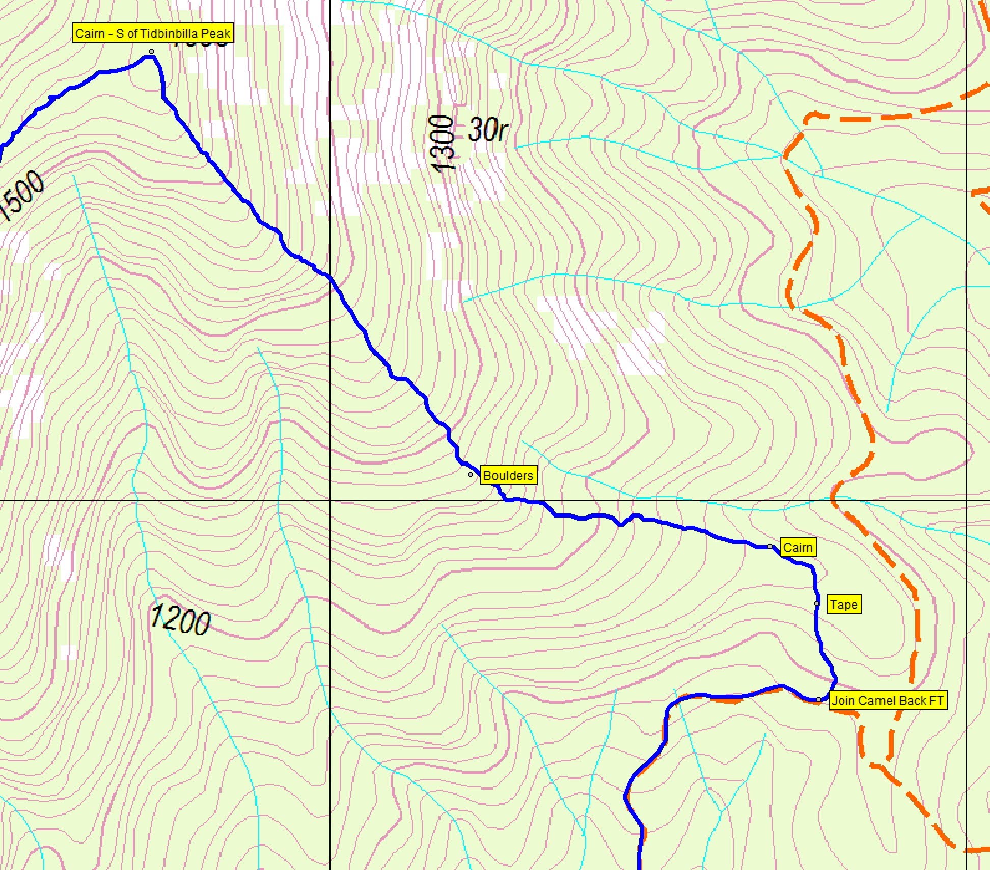
I took a photo of Rob H’s ‘Boulders’ map point, just for old times’ sake.

Rob H’s ‘Boulders’ map point
Joy, oh joy. I didn’t lose the pad today and followed it through a ‘Cairn’ I marked down to join the Camel Back Fire Trail.

‘Cairn’ near joining Camel Back Fire Trail
This leg 1.7km in 50mins, dropping 460m.
A quick pound down the fire trail to the car.
Extremely grateful to Ian and Rob for getting me there and back! Great trip!
Relive the Trip
Track Maps
Here’s where we went. On Tidbinbilla 1:25000 map © BKK Enterprises Pty Ltd, Mona Vale NSW 2103 www.gpsoz.com.au Used with permission.

Track overview The Pimple

Track 1 The Pimple

Track 2 The Pimple
Track 3 The Pimple

Track 4 The Pimple
The AllTrails map is here, where you can pan and zoom.
Route Card
| From | To | Distance (km) | Climb (m) | Time (h:mm) | Going |
| Mountain Creek carpark | Snowy Corner | 2.5 | 543 | 1:40 | Walking track, steep footpad |
| Snowy Corner | Tidbinbilla Mountain | 1.0 | 172 | 0:40 | Footpad |
| Tidbinbilla Mountain | Pimple turn off | 0.7 | 84 | 0:30 | Footpad, a little vague in places |
| Pimple turn off | The Pimple | 1.0 | -140 + 50 | 0:40 | Footpad, rocky climb |
| The Pimple | Pimple turn off | 1.0 | -50 + 140 | 1:00 | Rocky descent, footpad |
| Pimple turn off | S of Tidbinbilla Peak | 0.98 | 30 | 0:32 | Footpad |
| S of Tidbinbilla Peak | Camel Back FT | 1.7 | -460 | 0:50 | Footpad |
| Camel Back FT | Mountain Creek carpark | 1.7 | -177 | 0:21 | Fire trail |
(Metrics from OziExplorer Σ)
Party
3 walkers – Rob McL, Ian (the granite hunter) W, me.
Information Bit(e)s
I’ve had a lot of assistance from walking friends recently. By way of paying a bit back, I’ll publish a few bites of information that may help someone. Today’s is ‘9 I want to get to that track junction, but I can’t see it – what compass bearing should I follow?‘.
Darral Ashton
20 November , 2022 4:48 pmHi John
Another great report of an interesting walk. Can you tell me what the lime green PVC tee piece is that is in front of you on Tidbinbilla Mountain?
By the way I guess just found your videos on You Tube!
Can’t believe what I have been missing out on!
Cheers
Darral
Johnny Boy
20 November , 2022 5:22 pmYuma Darral. It’s a log book container. I saw it for the first time on 16/11/22, so was able to colour coordinate my top with it 🙂 Yarra. john