Saturday 19 August 2023: Orroral Valley Circuit * – L/E. Wanna 20km stroll out at Orroral? This newish route uses the Cotter Hut Road and Smokers Trail to take us to the top of the Orroral Valley. The walk south down the open valley on the grassy trail is very pleasant. It provides views up to the features on the Orroral Ridge of Stone, such as Sentinel Rocks, Trojan Wall, Legoland and the Belfry. As usual on trips such as this, there are a few Indigenous and European sites to visit. Around 20km and 400vm. A couple of wet feet crossing Sawpit Creek.
I was last here on 28 Jun 23, when we did the leg down the Orroral Valley.
As well as completing the full Orroral Valley Circuit, I was looking for signs of old Fishlock Yards. Many eyes make light work.
We were walking by 8.40am. A mite cool in the strong breeze and we walked quickly to get into the timber of the Cotter Hut Road. For a lot of the day, we had great views up to the Orroral Ridge of Stone. Coming back near the tracking station site, views also to Orroral Hill (Mt Orroral), the nearby ‘rabbit ear rocks and the geodetic observatory.
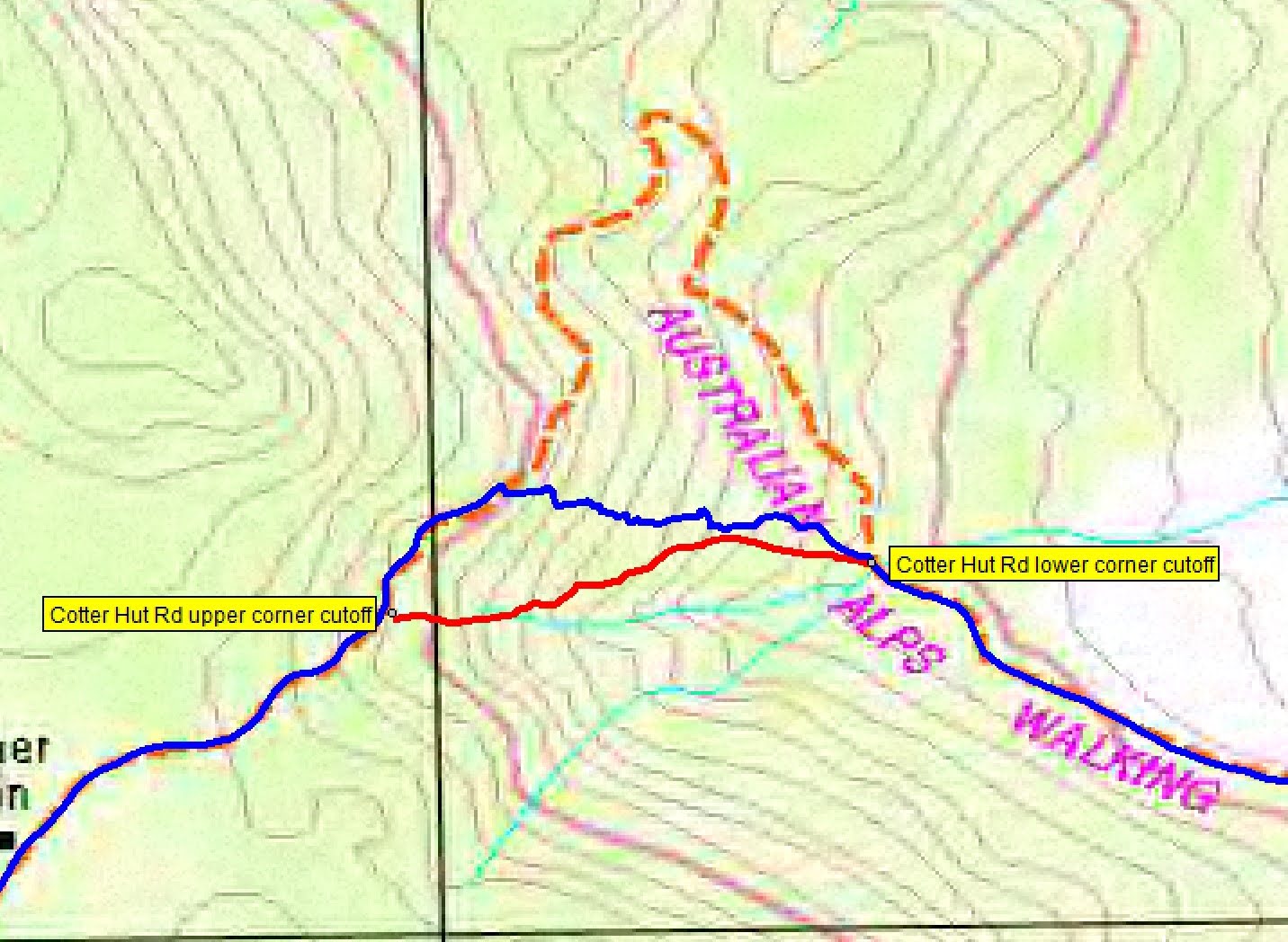
First whoopsie of the day for me was trying to negotiate the Cotter Hut Road bend shortcut. I didn’t have the old route with me and took a shocking line, as you can see:
We stopped at the spot where the Australian Alps Walking Track (AAWT) leaves Cotter Hut Road and went across to the Winston-Gregson OR18 Rock shelter site. For me, based on the evidence I have, this is the most likely location of old Fishlock Yards. (it’s called site 4 on that page). Today we had a good look around. There is a large flat area to its NW, really the only nearby location for a stockyard, but we saw nothing. Circumnavigating the granite blocks at the site, we went up the granite ramp at the back for morning tea.
Completing the walk around, I had a poke in the ‘cave’, entering from the S and popping back out the W side.
Front entrance
Side exit
We set off along the Cotter Hut Road again, passing near the waypoint ‘Possible location of old Fishlock Yards. In Fishlock Yards it’s called site 2 on that page. Distant views to ‘De Salis knobs’ and ‘Dutchies Peak‘.
We turned right onto Smokers Trail and walked it to the intersection with the Orroral Valley footpad. A section of mesh walkway fooled some into thinking there was a bridge across Sawpit Creek, but no. Several crossing styles. Charity was well balanced:
A very poised Charity crosses Sawpit Creek
Never too old to learn new tricks, Michael taught us a thing or two by putting on his waste disposal bags. He even had a third to put the wet ones in. Great trick.
A very sensible Michael crosses Sawpit Creek
In his 1978 thesis, Winston-Gregson identified, visited and photographed a site OR16, that he called Old Fishloch Yards.
Winston-Gregson site OR16
From the Map Grid and doing a resection on the Bearings, I calculated two possible locations:
OR16 search
We first visited the resections crossing. Of course, the bearings cannot be taken as pin-point accurate; have you ever tried to take an accurate bearing with a compass?
A search revealed nothing.
Looking to waypoint ‘Possible OR16 old Fishloch Yards from bearings resection’ with SH1339 at rear
In Fishlock Yards it’s called site 3a on that page.
We called lunch, sheltering from the wind behind small boulders and in a little hollow favoured by kangaroos (so the flattened grass indicated).
The OR16 also gave a Map Grid entry of 742 591. I converted this from AMG66 in use in 1978 to our current MGA94. For purists, Map Grid Australia 94 is based on the GDA datum and Australian Map Grid 66 is based on the AGD datum. There’s about 200m difference between the two. A new datum, GDA2020 differs by around 5m, insignificant to bushwalkers. Anyway, a 6 figure grid reference defines a 100m square, so I was not hopeful. I’d tried to refine this by looking at the portion boundary in ACTMapi.
Nothing there. In Fishlock Yards it’s called site 3b on that page.
Walking through waypoint ‘OR16 Old Fishloch Yards GR742591 AMG66’ with Orroral Ridge of Stone at rear
We regained the slashed track accompanied by views up to the Orroral Ridge of Sone.
View from the valley to Sentinel Rocks, Trojan Wall, Legoland on the Orroral Ridge of Stone
At 1.10pm we arrived at new Fishlock Yards. At least there was something there.
New Fishlock Yards (OR15)
We took in more views to the ridge.
Orroral Ridge of Stone from the valley
Then walked down to the Orroral River.
Orroral River down from new Fishlock Yards
Back up on the Orroral Valley Circuit we stopped briefly at OR14 hut site.
OR14 Hut site (438 tag)
Then on to pause briefly at Rowleys Orroral Hut site.
Crossing the Link Track, I was talking too much, so needed to circle back to the Concrete thingy.
Old render on concrete thingy
What do you think it is? I must pose the question to Tim the Yowie Man.
Views up to the SE end of the Orroral Ridge of Stone. I don’t think I’ve noticed the spire-like tor before.
The Belfry and is that spire tor in The Cloisters?
Back through the foundations of the minitrack area.
Laser site signage
Passed one of several good helicopter landing places.
One of several helicopter landing sites (2019-20 bushfire)
And that was it. Thanks all for humouring an old codger.
Track Map
Here’s where we went.
Track overview Orroral Valley Circuit
Party
8 walkers – Michael C, Richard H, Andrew J, Charity M, Stephen M, Lam SF, Jo T, me.
I’ve started up a FaceBook page. Each trip report posts to it. So it’s another way to get some info to get out and breathe a bit of fresh air. Why not pop over and Follow the page, or give a post a Like.


Minz
20 August , 2023 2:06 pmHelicopter landing site