
Mt Gudgenby and the Yankee Hats
Thursday 27 June 2024: Gudgenby Saddle Recce * – L/E-R,ptX. Great views of the Yankee Hats and Mt Gudgenby. Walk fire trails and an off-track route to Gudgenby Saddle from Yankee Hat car park. 7 years and 1 bushfire since I last walked it, so let’s call it part eXploratory. Early start and late finish at my pace. Around 17km and 550vm climb.
Summary
From Garmin Connect (recorded on Epix Gen 2) – Distance: 16.59km | Climb: 480vm | Time: 4:25 moving +1:35 of stops =6:00 | Grading: L/E,R; M(11).
Photographs
View photographs here.
gpx file
Download the gpx file here.
Track Maps
Here’s where we went.
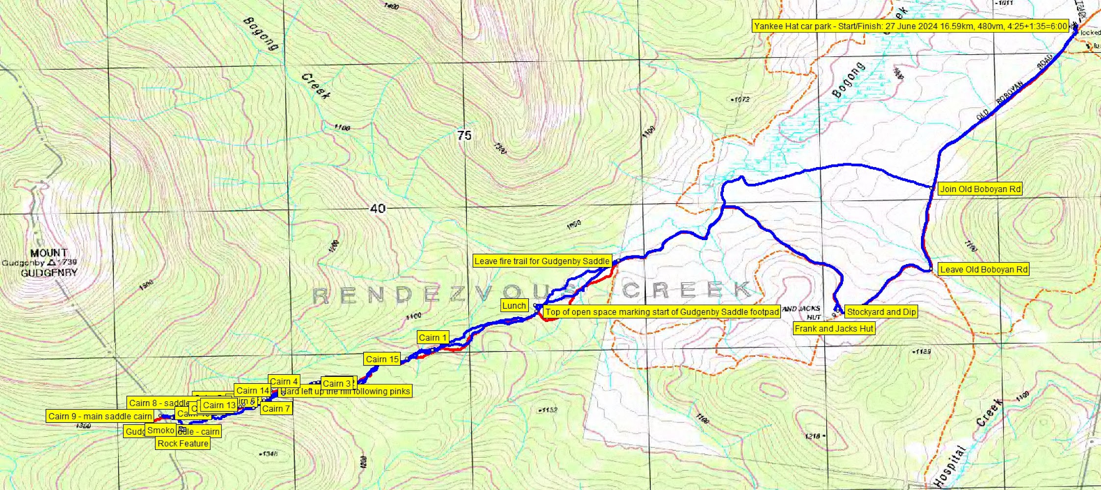
Track overview Gudgenby Saddle recce. Blue = walked route. Red = planned route

Route to Gudgenby Saddle. Blue = walked route. Red = planned route

Saddle detail. Blue = walked route. Red = planned route
Trip Report
The object of this trip was to recce the route to Gudgenby Saddle. Later in the year I’ll put on a trip that goes down to cross Naas Creek, pick up Sams Creek Fire Trail, walk the Naas Creek valley via Lutons Crutching Shed and return up the Old Boboyan Rd. This was a test to see if I could do the uphill bit.
I was going to walk it solo, but decided to put it up as a CBC trip. Gained two great companions (which made my dear wife happy) and the Assistant Walks Sec approved it to run with fewer than 4. We were well equipped with PLB and inReach satellite comms in the party.
We met at my old folks home at 7.00am and motored to the Yankee Hat carpark. Walking at 8.00am along the Old Boboyan Rd, with views to the ice on the Mt Gudgenby granite cap.

Ice on Mt Gudgenby from the Old Boboyan Rd
We dropped by Frank and Jacks Hut and dip.

Frank and Jacks Hut
More fire trails took us to the point where we were to leave the easy going. One party member commented that the scrub had not been too bad so far. 4.8km in 1:03. Nice views to the Yankee Hats.

Yankee Hat South and North from the fire trail NW of Fand Js Hut
Not a good route from here to the top of the open space. Crossed a swampy feeder to Bogong Creek. Corrected on our way out.

Crossing a swampy feeder to Bogong Creek
This little leg 650m in 0:12.
I had some intel from Garry B. Indeed it was the case that the footpad was still in existence for the first few hundred metres.

Footpad to Gudgenby Saddle 200m in
So the route to Gudgenby Saddle, via some nearby beaut granite that Garry had told me about, was 2.8km in 2 hours. The climb was from 1060m to 1340m at the rocks. I marked the cairns we saw. The going was a combination of the original footpad, animal pads and only one or two patches of tighter going. Most of the route is relatively easy through woodland (ie, treetops do not touch). As advised, there is a bit of fallen timber.

Tighter going between cairns 2 and 15
From the 1200m contour, we came in a bit higher than the planned route.
The rock feature was indeed groovy.

Granite features about 100m SE of the Saddle
We had smoko in amongst the granite.

Granite features about 100m SE of the Saddle
We dropped down to the saddle, hitting the little eastern cairn. The pedant in the group (appreciated by me) insisted on continuing a few tens of metres to the open area of the ‘real’ saddle with its larger marker cairn.
I was looking for a tibmin exit to the car, and Stevie took up the invitation to take us home. A truly excellent job, a little lower than the route in. We passed a lot more cairns as he led us pretty much spot on the planned route.
Lunch at the top of the open area on convenient and large log seating.
A better choice to cross the Boogong Creek feeder via a bridge.

No damp feet crossing the feeder via log on the way home
Slightly different fire trails to get us back on Old Boboyan Rd. Return trip was 7.1km in 2:40, including lunch. Finished spot on 2pm, so a 6 hour trip.
Great company from an old and new friend.
Party
3 walkers – Stevie E, Jonathan M, me.
AllTrails
The AllTrails map is here, where you can pan and zoom.
Johnny Boy’s Walkabout Blog FaceBook Page
I’ve started up a FaceBook page. Each trip report posts to it. It’s another way to get some info to get out and breathe a bit of fresh air. Why not pop over and Follow the page, or give a post a Like.