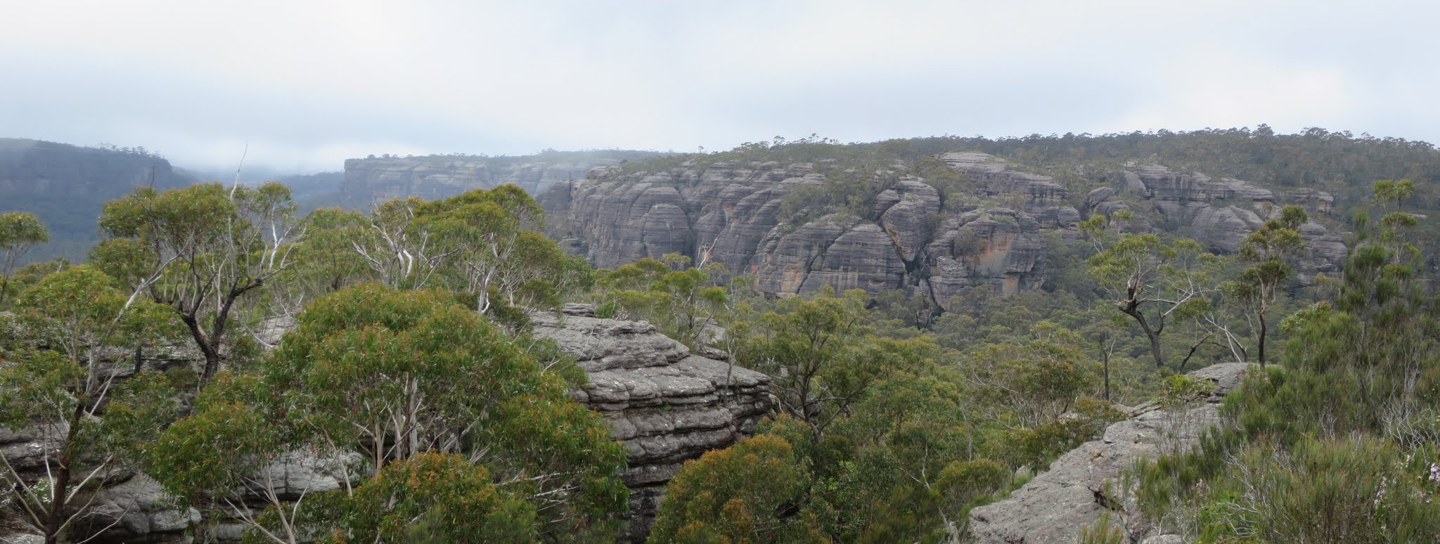
Sandstone cliffs to the south and east of Gilberts Gap from Gilberts Mountain
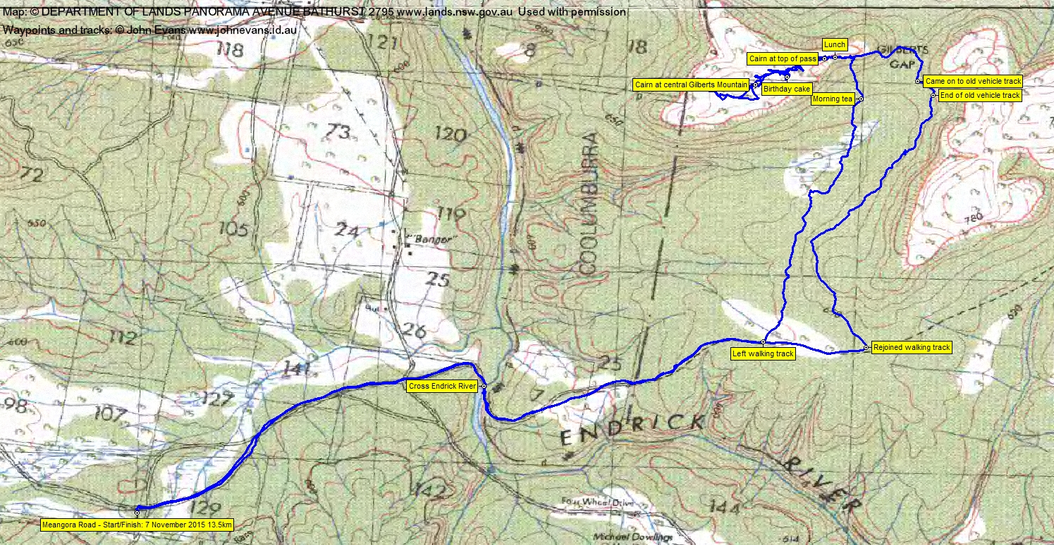
Saturday 7 November: Gilberts Mountain – M/M. Starting from near Nerriga, this Budawangs walk follows fire trails then heads to and up the sandstone mountain west of Gilberts Gap (top of map). The cliffs are breached through a series of ledges without significant exposure. The lunch spot is on top of cliffs with grand views across the Endrick River Valley. There is some scrub. Map: Endrick. Leader: Jeff B. Book by 2 pm the Thursday before. Transport: 250km return, ~$95 per car, $25–$30 per person. Limit: 12.
5 of us drove in 1 vehicle to the car park at the end of Meangora Rd.
Summary
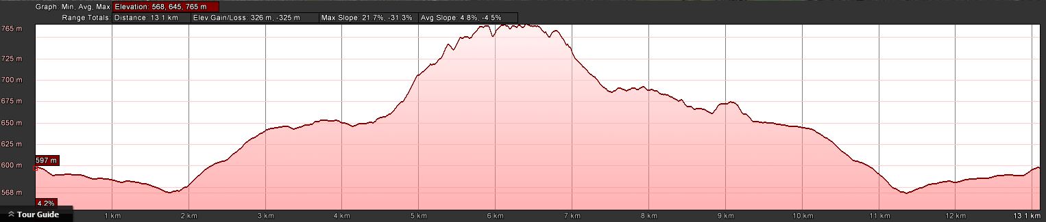
Distance: 13.5km | Climb: 325m | Time: 9.05am-3.30pm (6hrs 25mins), including 45 mins of breaks | Grading: M/M; M(10+)
Photographs
Photographs are available, where you can start a large sized slideshow.
Video
Waypoint and Track Files
Download the .gpx file. (Right click, Save Link As…, Save – if you want to use it.)
To use in Google Earth, do File, Open… and select Gps or All files as the File Type.
Track Notes
We were immediately into the flowers and birds in this spring season as we walked along the Endrick River walking track. A variety of styles to cross the river, around shin deep. I chose the don’t-bother-to-put-on-the-river-crossing-shoes-in-my-pack approach, so suffered wet feet for a while. Others chose boots-off-boots-on.
Around 1.5km further along the track we struck off into the bush. Low shrubs and hakea-type plants, but not too bad going. A bit damp through the swampy drainage lines. Morning tea at 11am.
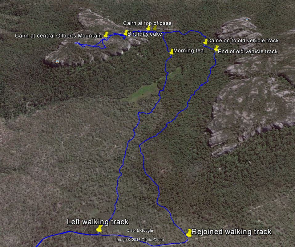
Soon after we began a gentle climb towards the pass Jeff knew off and it gradually opened up in from of us. An easy ascent with a few grunts up to a marker cairn made of a propped up rock at the top. We continued on for a bit, then stopped.
Here we split the party, with most of us going the extra few hundred metres onto the flat top of Gilberts Mountain. We had a look to the south and west but, not having been here before, I didn’t descend enough terraces to get to the top of the cliff lines and so we missed the view. In the back of my mind, too, was the thought that splitting a party is the first step towards disaster, so we only spent half an hour.
Regrouped, Jeff produced a home-made birthday mit candles. It was very kind of him. But the weather was looking a mite dodgy, so we descended half way down the pass to a nice spot for lunch. The cake was demolished!
Jeff had an excellent plan post lunch. We completed the descent of the pass, then continued east under the cliffs and wonderful sandstone formations to cross Gilbert Gap. Turning south and west, our higher exit was a lot dryer underfoot and the going mild-mannered. We came onto a short section of old vehicle track. Wonder where it went to in the opposite direction. We crossed and generally paralleled our exit from 4 Nov 14.
Rejoined the main walking track and so home.
Not a Mt Namadgi birthday walk this year. I’m not walk fit after the 5 week layoff to sell the house. But an excellent trip. I’ve done only around a dozen Budawang trips and it’s an area I’d like to know better. I am so fortunate to have received heaps of calls and cards and pressos and texts and social media posts on my birthday … and a lovely cake. Home to my dear wife who patiently lets me go walkabout.
Check out the photos and video. They tell a better story than I can.
Timings
| From | To | Distance | Time |
| Start | Leave walking track | 3.4km | 1hr |
| Leave walking track | Morning tea | 1.5km | 50mins |
| Morning tea | Lunch | 2.4km | 1hr 30mins |
| Lunch | Rejoin walking track | 2.4km | 1hr 10mins |
| Rejoin walking track | Finish | 3.7km | 1hr 5mins |
Track Maps
Track
Track from Google Earth
Profile
Party
5 walkers – Jeff B (leader), Quentin M, Phillip S, Jenny S, me.