
TNR and the Tidbinbilla skyline from GC9ZJK9 Best View towards Tidbinbilla Peaks (Skyline)
Thursday 6 July 2023: SE Rim of TNR from Corin Rd * – M/R,X. Climb to the south-east rim of the Tidbinbilla Nature Reserve from the gentler Corin Road side. Walk the crest NE to Stantons Gap. About turn and follow the watershed to the SW, traversing the various knolls and saddles to at least SH1356. A further 500m W takes us to the top of a spur for a look-see. The spur drops 500vm towards Fishing Gap car park and may provide a route for a future trip. Return down to Corin Road. Around 8km and 500vm. Two geocaches thrown in.
Summary
From Garmin Connect (Epix Gen 2) – Distance: 8.76km | Climb: 430vm | Time: 5:00 moving + 2:20 of stops = 7:20 | Grading: M/R,X; M(10).
Photographs Photographs are available here.
gpx File The gpx file is available here.
Track Notes
Never been here before, only to the Pyramid to the NE and Billy Billy Rocks further along the rim to the SW. Was scouting a possible future trip including a descent down to the Fishing Gap car park.
We drove up Corin Rd to a verge parking spot. Actually, it was better parking on the SE side of the road.
Walking at 8.30am. Crossed the road and headed up old fire trails towards the crest.

Old fire trail near the crest
At the top we left the fire trail and went NE down towards Stantons Gap.

Fog over Tidbinbilla Valley and The Pyramid from leg towards Stantons Gap
It looked pretty easy going down to the Gap, so it was decided not to go all the way down and return.

Near the end of the leg towards Stantons Gap
Returned up to the top and headed SW. A map-marked bit of fire trail on the SIX e-topo Tidbinbilla 1:25000 map didn’t really seem to be there.

Map-marked fire trail behind us
The crest took us up to a knoll …

Knoll 1 up ahead
… and down to a saddle.

The going approaching the saddle
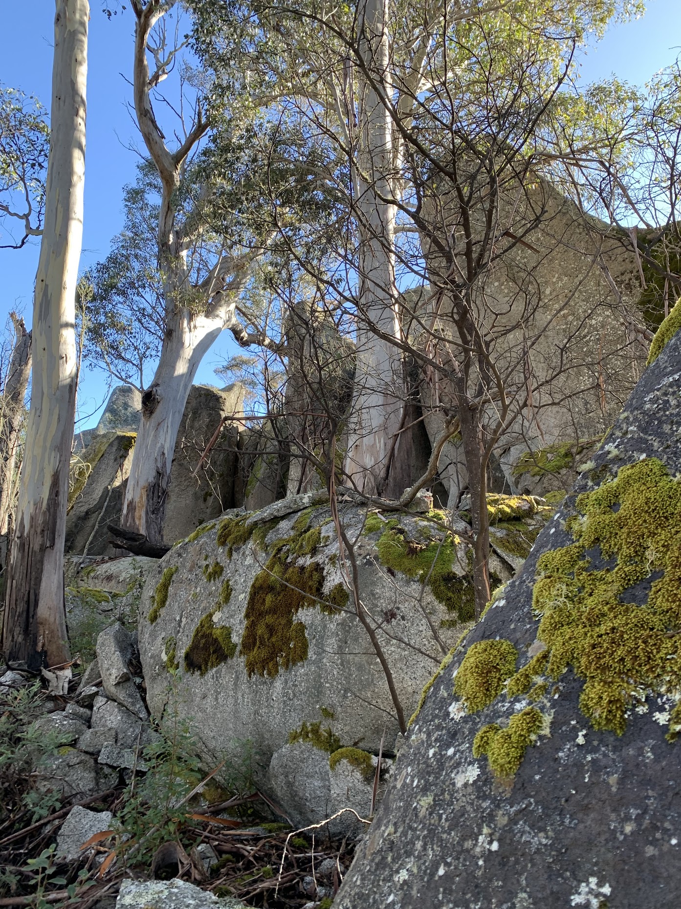
Then it was up again for one of the trip’s objectives, geocache GC9ZJK9 Best View towards Tidbinbilla Peaks (Skyline).

Small cliff line at Beat’s cache
Indeed the views were magnificent!
TNR and the Tidbinbilla skyline from GC9ZJK9 Best View towards Tidbinbilla Peaks (Skyline)
Marmaduke Rothschild and JohnnyBoyACT faffed around for quite some time to find the cache. It’s off location by around 10 meters. Thanks to Brigitte (StarsAlign) for the accurate spoiler pic. We agree with Martin that the terrain difficulty could be increased to 3.5.
A quick morning tea for the cachers.
We continued SW along the crest, past Knoll 2. Approaching SH1356, we encountered some lovely granite tors.
Granite tors near SH1356
Photos don’t do them justice, they were huge.

Granite tors near SH1356 – they were huge
Roger found a passage way through to the other side of the crest. Began as a standing squeeze and finished with a crawl.

Roger found a crawl through to the North side
Equally amazing tors at the Spot Height.

Granite tors at SH1356
We continued W-ish, with distant views to Billy Billy Rocks.

Billy Billy Rocks from SW of SH1356
The aim of the recce was to check out a descent from the rim down into TNR. We reached a location that provided a lousy photo but a good spot to go down on a possible future trip.

Bad photo of possible route down to Fishing Gap car park
The leg back from this point to near SH1356 was a lot better than the route in!
We skirted SH1356 to the SE and started a sidle down towards the fire trails.

Descending NE of SH1356
Around 2pm I took a tumble and ended up with my right shoulder against a tree. I didn’t realise I had so many foul words still in my memory, but they all tumbled out.
A very well equipped party. 4 mobile phones, 4 GPS receivers, at least 2 inReach SOS devices, all experienced walkers. Roger, with many, many years of bushwalking and SES experience, swung into action. With phone reception, we didn’t need to action an inReach SOS. Police contacted.
It took 1hr 20mins to descend the 600m to the fire trail. Mike ahead finding the best route, Stephen supporting me, Roger in contact with police rural patrol, me swearing. I’m glad we were able to keep moving, as it would have taken some considerable time to get help up the hill.
We gained Corin Rd and walked to my car. There were 2 police cars there. An ambulance pulled up 30 seconds later.
A dislocated shoulder, no broken arm. ED knocked me out and popped it back in and I was home by midnight. Some nerve damage and I can’t feel my fingers much at the moment, but they’ll come good. Typing this left hand.
This incident was not a further example of the recent spate of reported bush rescues around Canberra. Sure, it was a rescue resulting from an accident. But we were a very well equipped and experienced party and we knew where we were. The Canberra Bushwalking Club has rigorous training and safety and check-in procedures.
I am very grateful to my fellow walkers, police and ambulance, and Canberra Hospital ED staff. And to concerned family and friends. As Arnie said, “I’ll be back!”
Track Map
Here’s where we went.

Track SE Rim of TNR from Corin Rd
The AllTrails map is here, where you can pan and zoom.
Party
4 walkers – Roger E, Stephen J, Mike M, me.
Johnny Boy’s Walkabout Blog FaceBook Page
I’ve started up a FaceBook page. Each trip report posts to it. So it’s another way to get some info to get out and breathe a bit of fresh air. Why not pop over and Follow the page, or give a post a Like.
Terrylea Reynolds
8 July , 2023 12:25 pmYou can’t keep a good man down for long! We should trade cussing words. Mark tells me I used words he’d never heard during childbirth, ha ha.
Johnny Boy
8 July , 2023 12:31 pmHi TL. I’ve never had the joy of experiencing child birth first hand, but they say the pain level and language is similar to a dislocated shoulder :-). This left hand finger typing is laborious, as you know. Cheers. john
Barrie Ridgway
8 July , 2023 1:12 pmBad luck, John. Glad you are OK (more or less) and were able to walk out. Hope you’re feeling better today.
All the best
Barrie
Johnny Boy
8 July , 2023 1:17 pmHi Barrie. Thanks for your well wishes. Cheers. john
Lena
8 July , 2023 3:01 pmHi John,
Sorry to hear about your misadventure, but so relieved that it ended well! Hope your recovery doesn’t take too long. Must say I cannot even imagine you using that kind of language 🙂
All the best,
Lena
Johnny Boy
8 July , 2023 3:08 pmHi Lena. Thanks for your concern. I thought I’d forgotten all those words! Cheers. john
Paul Regan
10 July , 2023 9:12 pmGet better soon
Johnny Boy
10 July , 2023 9:32 pmHi Paul. Thanks for your good wishes. Cheers. john