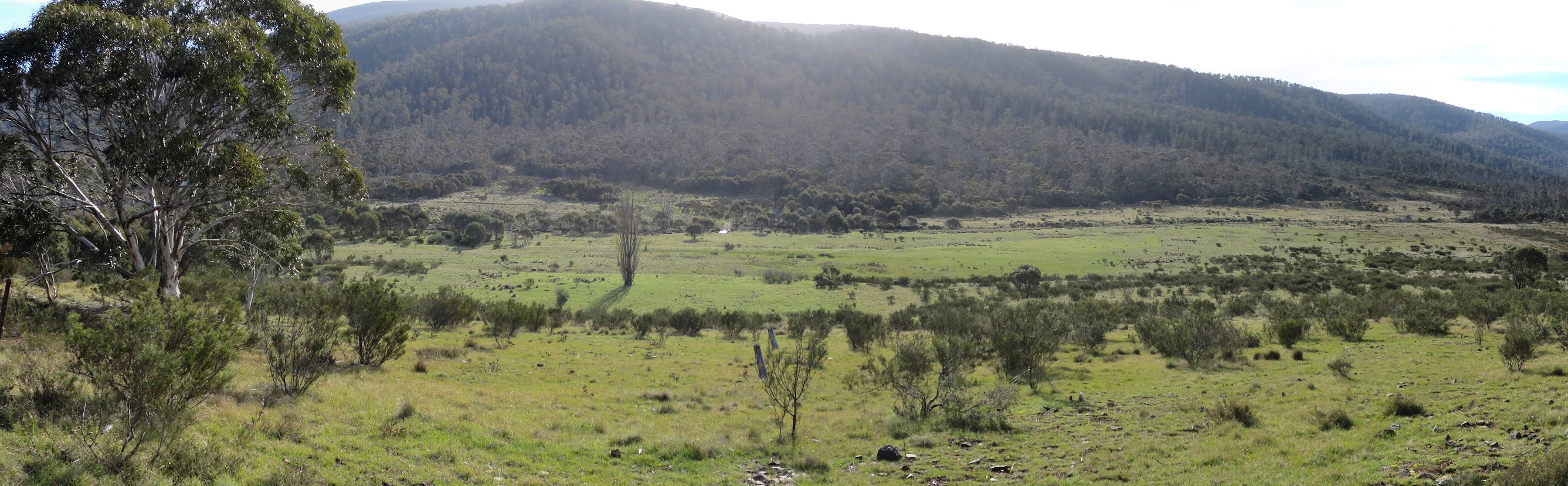
Cotter Flats and the Oldfields Homestead site
Sunday-Monday 6-7 November: Bimberi Peak from Orroral – L/E. The 3 musketeers hit out together. Hooray. Leader: Max S.
3 of us met.
Further Information
Similar to the trip 3 weeks ago, 16-17 Oct 16.
Summary
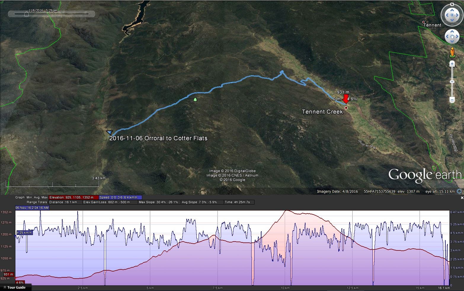
Distance: 51.2km | Climb: 2060m | Time: 1 and a ½ days | Grading: L/E; H(12)
Photographs
Photographs are available, where you can start a large sized slideshow.
Video
turn off your sound, no commentary
Waypoint and Track Files
Download the day 1 .gpx file and day 2 .gpx file. To use in Google Earth, do File, Open… and select Gps or All files as the File Type. Download the entire trip .gpx file.
Track Notes
We three young fellas are off to Tasmania next year, so thought we might have a training walk together. Thanks to Max for organising.
The walk also provided an opportunity to use my new family birthday presso of a Jetboil MiniMo and to spend my day on a high hill.
I decided to take my car as well, to give me the option to return late Monday night. Pleased with 12.3kgm in my bag (including 500ml of port), depending on the weather forecast for a mild night.
Day 1
We enjoyed lunch at the shelter at the Orroral Tracking Station, then set off up the valley to join the AAWT, passing Rowleys Orroral Valley hut site, then on up to join Cotter Hut Road. A climb up the side of the valley, then along to where the Australian Alps Walking Track leaves Cotter Hut Rd. Still some nice wildflowers about. A stop at Sawpit Creek for a breather and water, then the grind of a climb up to Cotter Gap. Down the other side you have that amazing vista of Split Rock. By now we were walking at our own pace, as one can do on a track with the leader’s nod and with regroupings every now and again. Next, down the Pond Creek cut, with another breather and water stop at Pond Creek. Continuing on, the next great site is Coronet Peak. Then the tromp to above Cotter Flats, where we looked down onto our destination for the night. 16.1km with 600m climb, 1.05-5.30pm.
It was a bit exposed and breezy, so we chose the shelter of some small growth. It was kanga h(e)aven – these roos mustn’t see that many people, but they were so close to us. Tea, a celebratory drink, then to bed. No fire, as the Bimberi Wilderness is a fuel stove only area. A noisy night, with all the planes going over and the grunting kangaroos. Another early morning fail of the old man test 🙁 .
Day 2
Nosy neighbours. Up, breakfast and away by just after 7. Down to ford the Cotter River, about shin deep. Then south along Yaouk Trail past Cotter Hut and a puff up the Murray Gap Fire Trail. It’s steep! A spot of water from one of the creeks, then we were finally out of the trees and into the open, damp area leading up to Murrays Gap. The sign evokes many great memories. I had a quick look at other camping area options nearby, with a little fewer large trees nearby. Then another slog up from Murrays Gap to the top, not too bad, just keep at it, even with day packs. As last time, the footpad is heavily cairned and taped. One is nearly there (∼1km out) when the pad turns north-west up the more gentle Snow Gum spur. The trig finally comes into view and one closes on the destination. Another walker there today. It was Greg Hutcho, who’d come in from Dunns Flat in the west. Too good not to be here, even after another recent trip. The view includes ‘… a few of my favourite things‘. Check out the video. Time for husbands to dutifully call home and some social media contact 😆 . Then down to Murrays Gap where we regrouped. Here Max kindly allowed me the flexibility of walking out. I thought I should spent at least a few hours of my birthday with my dear wife. A long and hard exit. Fat glossy black snake coming off Murrays Gap; packed up my camp at Cotter Flat; a trudge up to Cotter Gap meeting a couple and two singles en route to Walhalla; made some soup at Sawpit Creek and back to the car by sundown. 35.1km with 1460m climb, 7.10am-7.35pm.
Thanks Max and Eric. I’d walk anywhere with you guys.
Track Maps

Party
3 walkers – Eric G, Max S (leader), me.