Bimberi Peak bag

Sunday-Monday 16-17 October: Bimberi Peak – L/M. With road conditions in the west reportedly not good, a short drive and a long walk in from Orroral in the east, rather than a long drive and a short walk from the west. In via Cotter Hut Rd, camp at Murrays Gap. Checkout the Cotter River ford on the return and, if crossable, out via the AAWT. Around 55km and 2000m climb over 2 days. Leader: John Evans, john@johnevans.id.au 0417436877.
Geocache GC68E8G Bonus Surprise II
2 of us met.
Further Information
I reckon anyone who is willing to fly half way down Australia to walk to the ACT’s highest hill deserves some support, so when Joy contacted me to do that on the CBC advertised walk for HWC, we made some arrangements. She’s on a quest to summit the highest hill in every state and territory and this was to be #6 of 8. The bookings (no one else wanted to come), pre-walk flight and the weather forecast for Monday did not work well. Advice from the Namadgi Visitors Centre when I applied for a camping permit was that they did not recommend camping in NNP until November, due to the saturated ground and current high winds. Joy’s flight arrived in Canberra at 5.30pm instead of 11.30am. So we had some tea, changed to plan Z, had 3 hours sleep, got up at 11.30pm and drove to Orroral.
Summary
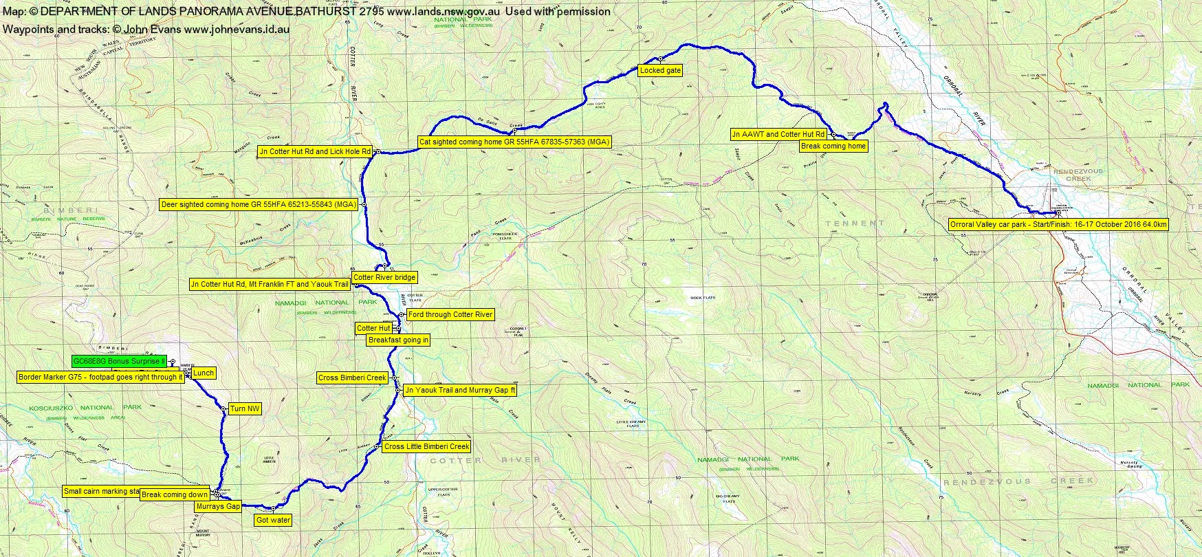
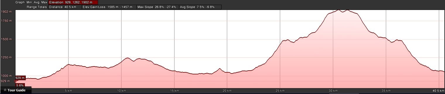
Distance: 64.0km | Climb: 2120m | Time: 2 days | Grading: L/E-M; VH(16)
Photographs
Photographs are available, where you can start a large sized slideshow.
Video
(turn off your sound – nothing but the roaring wind)
Waypoint and Track Files
Download the .gpx file. (Right click, Save Link As…, Save – if you want to use it.)
To use in Google Earth, do File, Open… and select Gps or All files as the File Type.
Track Notes
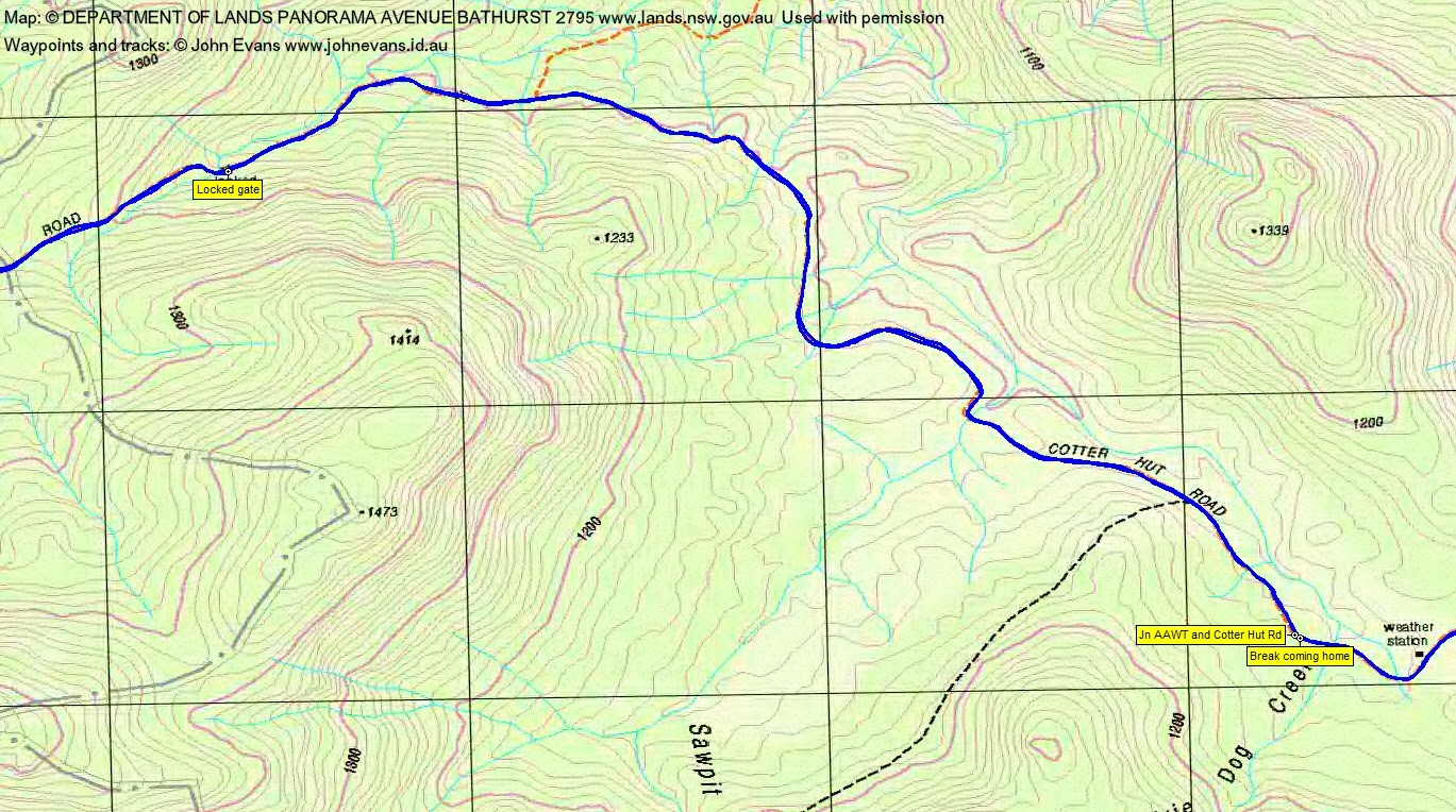
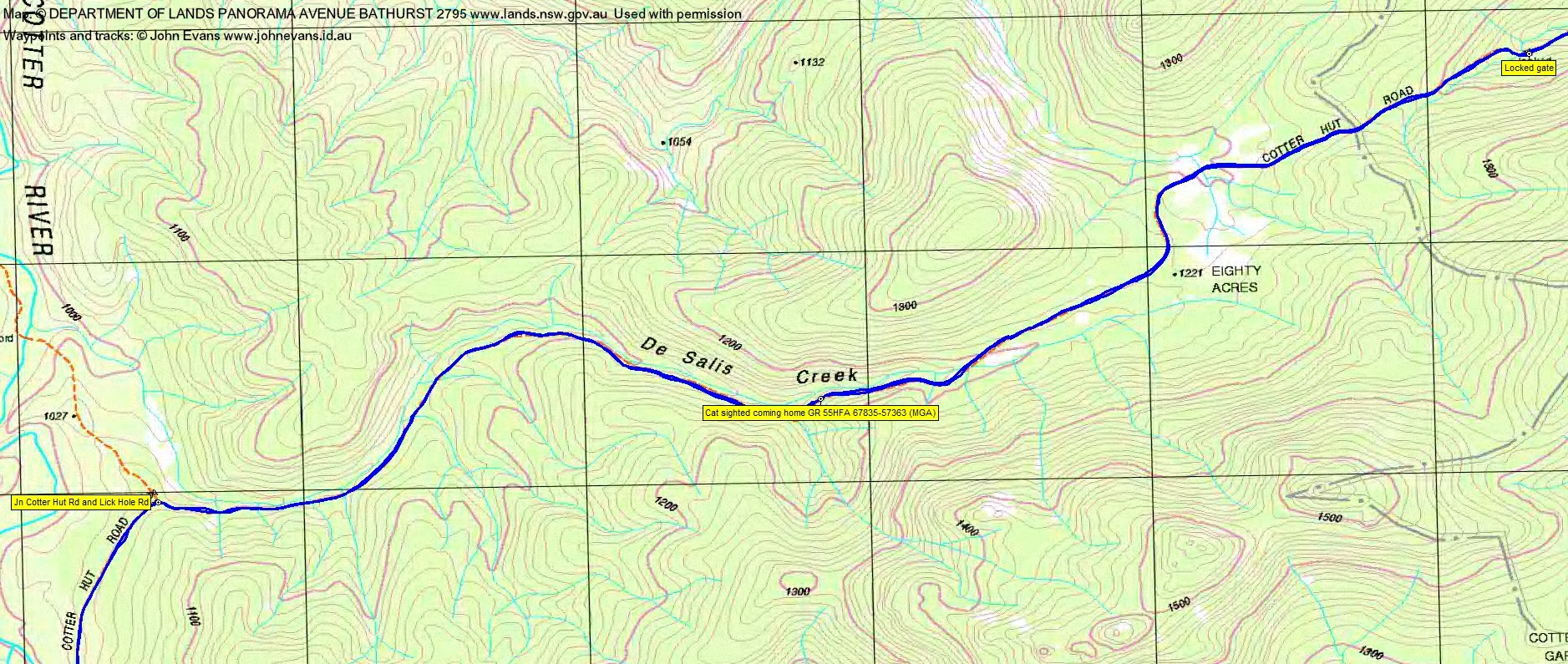
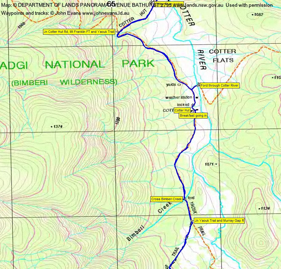
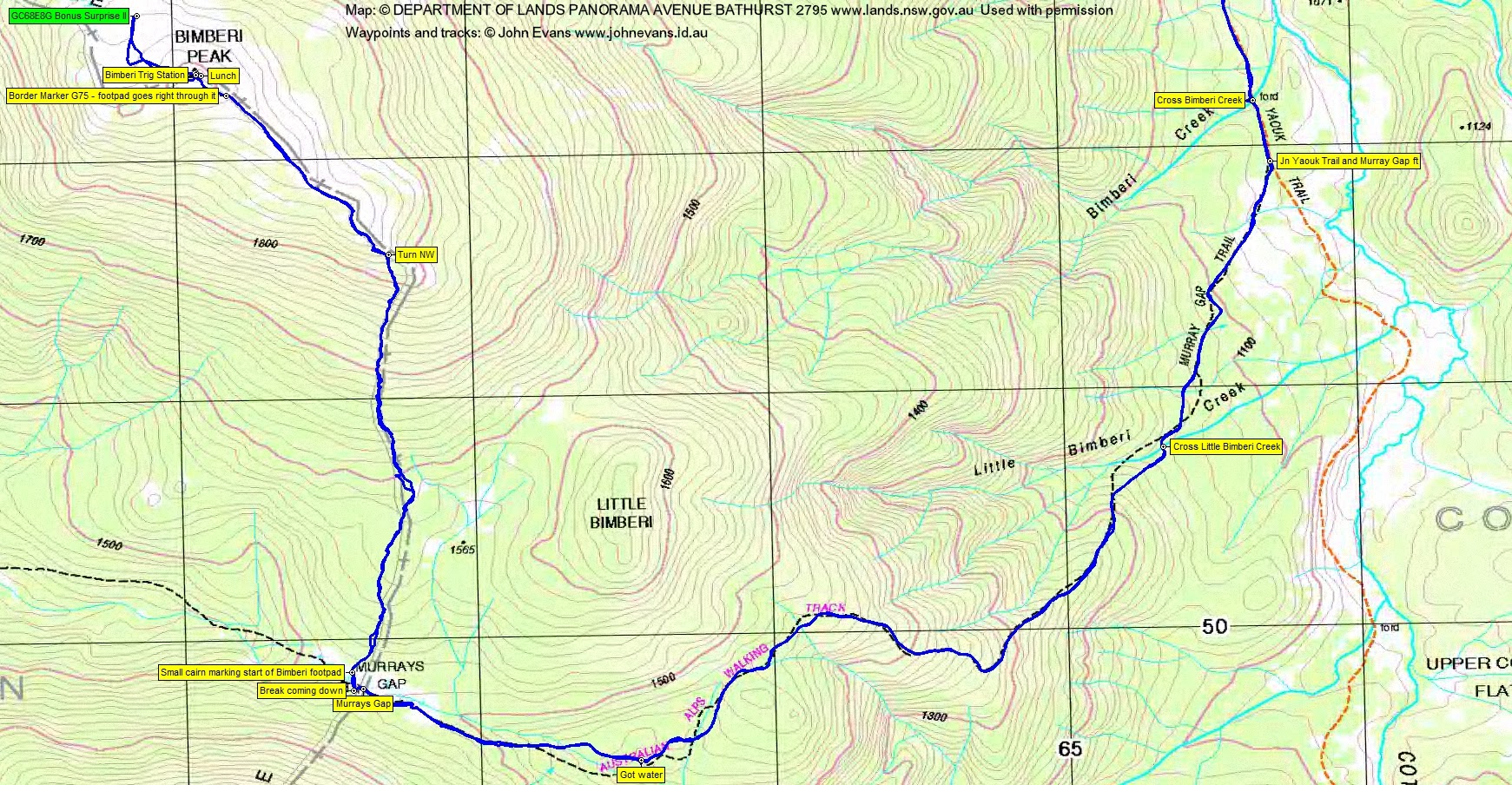
Set off at 12.30am. What a fabulous night – full moon! Not a torch was ignited as we walked via the Cotter Hut Rd to Cotter Hut. Our shadows were nearly as bright as day and we had to shield our eyes when looking towards the moon. I love night walking and this was perfect. Joy is fit as a fiddle and we covered the 21km via the Cotter Hut Rd to Cotter Hut in 4hrs 30mins. Creeks could be heard – and seen in the moonlight – running everywhere; James, Prairie Dog, Sawpit, De Salis Creeks, the Cotter River and the unnamed creek at the intersection of Cotter Hut, Rd, Mt Franklin fire trail and Yaouk Trail. A break at the Hut for breakfast.
We dropped some of our gear, deciding to make a ‘today’ assault on the hill with a day-pack type load, then come back down to camp. Our next leg took us south along Yaouk Trail and right onto Murrays Gap Trail. The bird song and pink sky heralding the sun were a wonderful sound and sight. Very windy. The 300m climb up after crossing Little Bimberi Creek was not so wonderful. But the gradient finally eased and we were able to talk again and appreciate the wattle (still well in bloom at these higher altitudes). Nice walking on the soft fire trail. We picked up a little water from one of the creeks and soon broke out onto the very wet open country leading up to Murrays Gap. Good views to the rocky Mt Murray east knoll; Bimberi looked a nice rounded hill. Reached Murrays Gap at 7.50am, having walked the 6.8km in 2hrs 15mins. There was a freshly uprooted tree blown down near the spot we normally camp – would not have been good to be under that.
A soft sugar jelly in our tummies, we headed for the cairn on the north side of Murrays Gap which marks the start of the footpad to the top. The route is heavily cairned and even more heavily taped (but I managed to still make a couple of oops-es). The final 1km approach to Bimberi Peak after turning north-west up the more gentle spur is always a delight. Burnt white snow gums, but also new growth and some recovering. The footpad is clear; a few feral horse droppings. Perhaps 500m from our destination Bimberi trig was sighted and there was renewed vigor in our step. Summited at 9.20am. The trip up from Murrays Gap was 3.1km in 1hr 30mins.
Much congratulations for Joy’s hill #6, with only SA and WA to go. Needed to hold on in the wind gusts. A couple of remnant snow patches. An opportunity for social media contact and calls home, then retreated to the lee side of the rocks for shelter. We were top dogs in the ACT, even though there’d been an election yesterday.
I took the opportunity to wander ∼300m to the NW to gather information for a geocache at a feral horse/brumby (depending on your point of view) yard. Back at the trig, time for a little food and a bit of a spell.
We left the top at 11.05am and did the 9.8km return leg in 3hrs. A lot more pleasant walking down hill and the chance to more fully appreciate the bush. I logged the final GZ of the cache in the field.
A little mucking around followed, although by now I, at least, was a little weary. We wandered down to check out the Cotter River ford – able to be crossed at perhaps knee deep, but flowing very strongly. The wind was still gusting, so we sorted out a place to camp. The camping permit specified not within 100m of the Cotter River and not within 500m of Cotter Hut. Tents up, Joy had tea and went to bed. I had a 2-hour doze, then tea, and was in bed by 6pm. A bit of a wild night, with wind and rain, but no tree falls until the next morning on the way out.
Thankfully, it stopped raining for breakfast and breaking camp, then drizzled all the way home. We left at 7.45am. Not wanting to spend the rest of the day in wet boots and socks, the decision was made to not ford the Cotter, so we went home the way we came in. Plenty of company on the way – a stag above Black Sallee Flat, a cat beside De Salis Creek (both reported to NVC), beetles and worms out for a walk. 4hrs 40mins for the 20.8km trip.
Many changes of plan, but I think it was right in the end. A bit of a miserable day on Monday which certainly wouldn’t have given views from Bimberi. Possibly a problematic drive out if we’d come in from the west.
Thanks for your company and friendship Joy. Congrats on the bag. Maybe we’ll meet again in the bush somewhere.
Track Maps


Party
2 walkers – Joy S, me.
Post Script
In August 2017 I received a fabulous text from Joy. She has climbed all the highest mountains in Australia’s States and Territories! The photo from her WA and last Mt Meharry included Karina, with whom I’d walked to Bimberi Peak on 23-24 May 05. So I’m presuming that both of these focused ladies have done them. Huge!
Ben
19 October , 2016 10:11 amSounds like a fantastic walk! I’d love to do that one day. Perhaps at Xmas time, since I’m now working in interstate and far from those great mountains.
Johnny Boy
19 October , 2016 11:59 amShorter and easier from the west from Pockets Saddle Rd ?