The footpad leaves Bimberi Peak
Saturday-Sunday 23-24 May 2015: Bimberi Peak from the West – M/M-R.Trip depends on weather (road closed the following fortnight for winter). A 3 hour, 220km drive via Cooma, Adaminaby, Tantangara and Pockets Saddle Rds to the locked gate at Gurrangorambla Creek. Walk fire trail to Oldfields Hut, then AAWT to Murrays Gap to camp, 8km. Either an afternoon or next morning ascent of Bimberi Peak with day packs, 6km return and nearly 400m climb on rough footpad. Huge views, 2 geocaches. If time and interest, we could whip up Mt Murray for another cache. Around 23km and 950m climb. Maps: Rules Point and Rendezvous Creek. Leader: John Evans 0417 436 877 john@johnevans.id.au . Transport: ∼$40 per person. Limit: 8.
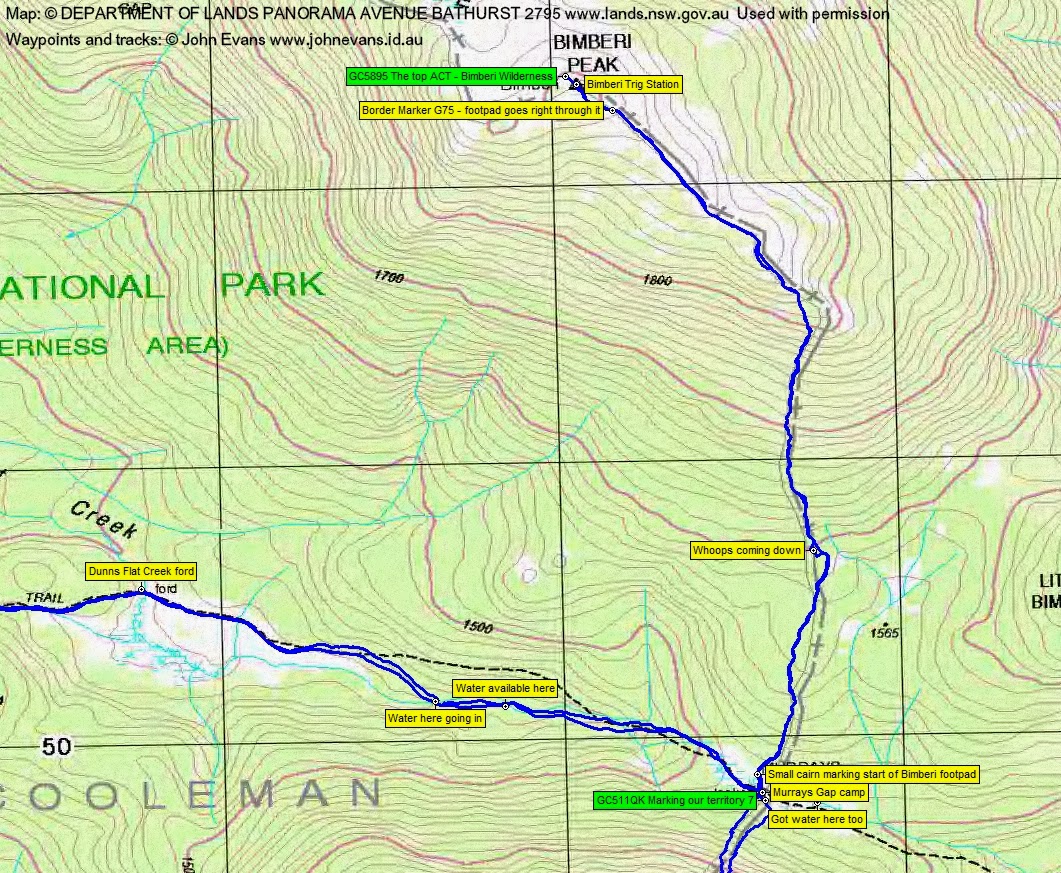
8 of us drove in 2 SUVs via Cooma, Adaminaby, Tantangara Rd and Pockets Saddle Rd to the Gurrangorambla Creek car park.
Further Information
@chifley_alison couldn’t make it, so we’ll have to go back some time.
Summary
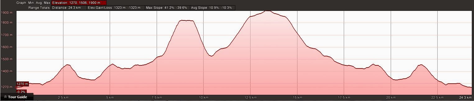
Distance: 24.9km | Climb: 1320m | Time: 2 easy days | Grading: M/M-R,ptX; M(10)
Track Maps
Track overview
Track 1

Track 2

Track 3
Profile
Photographs
Photographs are available, where you can start a large sized slideshow.
Waypoint and Track Files
Download the .gpx file here. (Right click, Save Link As…, Save – if you want to use it.)
Download the .kml file here.
Track Notes
Karina is a brave lady – to book on a walk advertised on my blog and fly down from northern NSW, sight unseen. But Bimberi was her penultimate hill in the Australian States/Territories highest in each, so she was prepared to risk much.
I must say that we were extremely fortunate, nay blessed, with the weather. Two beautiful sunny days! The coldest part was as we left the fire for out tents on Saturday night and breakfast conversation was laced with stories of campers divesting themselves of clothing during the night. Far from the -3ºC forecast, the overnight temperature must have been a few degrees above zero.
We left southern Canberra a bit after 7am. No animals or cars were injured on the drive. Two small mobs of brumbies on Tantangara Rd as we drove in. The dam was shrouded in fog. The road good; a little damp on the climb out from the Murrumbidgee River crossing. My car with the ladies enjoyed coffee and home-made muffins as we travelled – thanks CC.
We were walking by 10.20am and, although not warm, layers began to be shed as we walked up the rise in the Murray Gap Trail towards Oldfields Hut. A break for morning tea at the rustic hut.
We continued at a mild mannered pace, picking up water from Dunns Flat Creek around 1km below Murrays Gap. Arrived at our camp site at the Gap at 12.50pm after an 8km walk in. I immediately grabbed the geocache GC511QK Marking our territory . (The location is a bit loose – check noikmeister‘s correction.)
We set up our tents and had lunch, then most of us went for a bit of a puff up to Mt Murray East. Only 1.2km taking 1hr to the western tor, but a 300m climb caused the puff. A bit of a band of scrub at the bottom, then relatively easy going. We hit the crest on the saddle between Mt Murray West and Mt Murray East, a beautiful area of Snow Gums and grasses. It took a few minutes of scrambling to top the tor, only to find that the geocache I was hunting was over near the eastern tor. So most of us went over there. A quick find and log of GC4YDK2 The Third ACT – Mt. Murray.
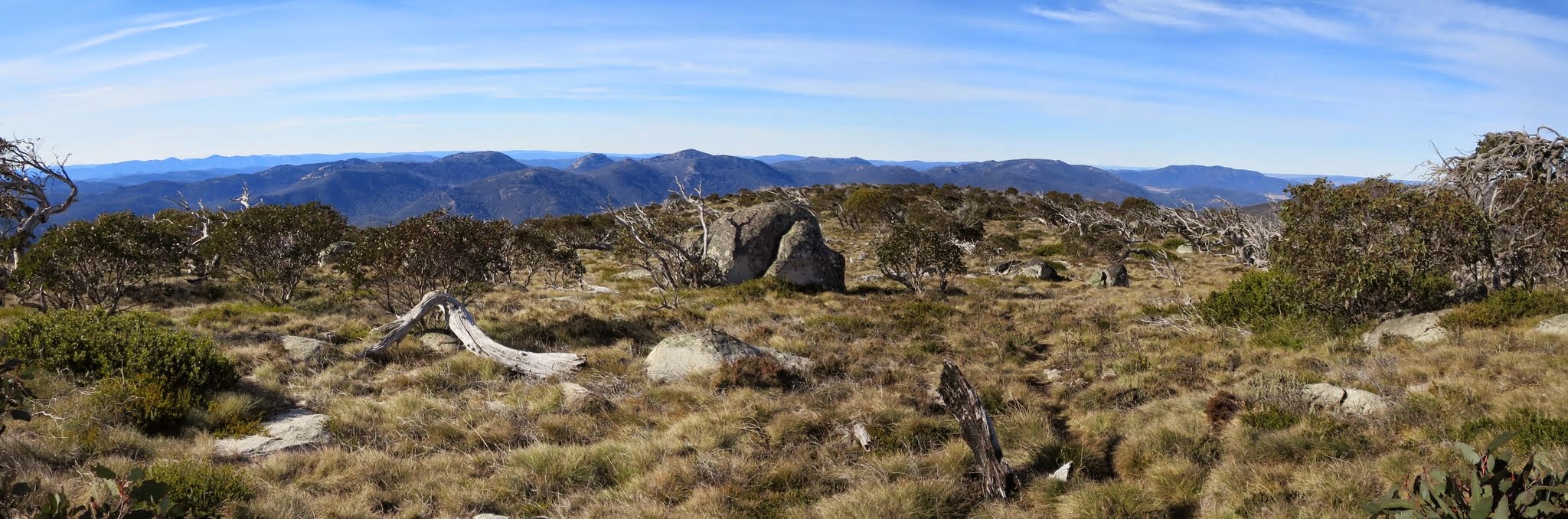
Stunning views south to Mt Morgan and east and south to the high hills of the Namadgi. It was a bit cool in the breeze; a pool of water up there was iced over.
Returned pretty much the same way, except for dunderhead route finding towards the end of the descent. I got a little east of our upward track and came down a densely vegetated drainage line for the last couple of hundred metres.
A fire had been lit and we enjoyed our dinner and a chat. Needing my beauty sleep, I piked at around 7.30pm. I’m told the starry sky was magnificent.
Up at 6.30am after, as mentioned above, a very mild night. Not a spectacular sun rise. Breakfast, then away at 8am north across Murrays Gap to the cairn marking the start of the footpad to Bimberi Peak.
I was last here on 25 Apr 13 and I must say that the footpad has developed incredibly since then. That’s really great, because it means that lots of people are going up to enjoy the views. At the moment it’s also quite heavily taped and, of course, quite a few cairns. Again, quite a leisurely ascent, the 3km and 380m climb taking 1hr 25mins. The last gentle spur from where the track turns NW is gorgeous – nice and grassy and the Snow Gums are coming back so well.
We made the trig at 9.30am and drank in the views. So much so that I had to be reminded that there was a geocache to find. Duly logged GC5895 The top ACT – Bimberi Wilderness.
Being the highest hill in the ACT, Karina had made her journey to bag it. She’s off to WA in a while to climb its highest hill and then will have done the lot. Well done Karina!
One of our party on his first visit to Bimberi wanted to stay all day, he was enjoying the views so much, but after 30 minutes it was time to go.
A leisurely descent too, taking 1 hr 25mins. Of course I momentarily lost the track at the ‘whoops’ point.
Back at camp we found a message charcoaled on a log concerning a lost hat. We’d passed two blokes coming down as we went up. Most disappointed, as it’s a very good and new hat, and I thought it would see out my walking years. Now it has to be returned to the owner. Had lunch, broke camp.
Left at 12.35pm and strolled out, doing the 8km to the cars in 2hrs 5mins.
A couple of lyrebirds across the road as we drove out.
This really was a beautiful weekend. Absolutely fabulous weather, great company, easy and slow paced walking and 3 geocaches. Thanks all!
Party
8 walkers – Evelyn C, Cynthia C, Karina H, Trevor L, Stephen M, Darren R, Llewellyn S-P, me.