Blue-green hills from Mt Tennent

Tuesday 31 January: Mt Tennent – L/E. A morning walk up Mt Tennent. Around 14km and 800m. Approximately 4 hours. Bring plenty of water and morning tea. Map: Williamsdale. Leader: John Evans 0417 436 877 john@johnevans.id.au . Transport: Drive yourself to meet at the Namadgi Visitors Centre outer car park at 6.30am. No need to book.
Further Information
Rudy was in town for celebrations and called for a walk. Happy to oblige (glad he didn’t suggest taking me swimming). Popped it out as a CBC short notice walk and scored another 4 exercisers.
Summary
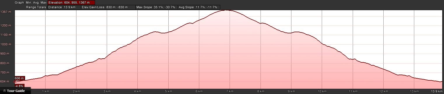
Distance: 14.1km | Climb: 830m | Time: 6.40am – 12.35pm (5hrs 55mins), including 30 mins of breaks | Grading: L/E; M(9)
Photographs
Photographs are available, where you can start a large sized slideshow.
Waypoint and Track Files
Download the .gpx file. (Right click, Save Link As…, Save – if you want to use it.)
To use in Google Earth, do File, Open… and select Gps or All files as the File Type.
Track Notes
Pleasantly surprised when four others turned up for a little exercise on a forecast 36ºC day, but with our 6.30am start and climbing to 1384m it was a little cooler than that. A bit humid and sweat-making when no breeze. A pleasant cool breeze on top.
The Mt Tennent Track (actually the northern start of the 640km Australian Alps Walking Track) starts through the Namadgi Visitors Centre woodland area, crosses Naas Rd, then beguiles one as it continues fairly flat through grasslands and woodland. Then an easy climb to Cypress Pine Lookout where we had a break and took in the views. 2.2km and around 170m vertical climb to here.
Here we saw the last of the others (except as they came down) as Rudy and I set our own pace. A couple of American ladies passed us and we were able to relay a message to our mates to not wait for us. The track climbs a little, turns to the north and crosses two drainage lines (dry today except for a couple of fetid pools) via bridges. It then contours across to the next spur where the major climb of around 300 vertical metres begins. The track zig-zags in places to ease the ascent, passes through a couple of great vantage points with views to the east and north and climbs a great rock staircase which is a picture in spring. Not many wild flowers today, a few daisy bushes and the ubiquitous Cassinia. At last the grade eased and we popped up through the trees to the T-intersection where the AAWT now leaves the Mt Tennent Track to the north (the AAWT on the map segment has been realigned since the 2003 bushfires). This leg 2.3km in 1hr 15mins.
The track then turned SW and SE (actually with a fraction of down!) and in 1.2km we were at the open saddle which once held Tongs sheep yard. A few metres further on we joined the Mt Tennent Fire Trail.
This gravel road climbs around 1km to the top of Mt Tennent. Today it took us 35mins to walk, climbing the final 150 vertical metres. We met the other guys coming down near the top and the American walkers on the top.
Great views. Close at hand the the west Blue Gum Hill, Booroomba Rocks and Deadmans Hill are prominent. Bimberi Peak and Mt Gingera can be seen on the western skyline, with Mt Gudgenby further south. On the east, the Clear Range stretches south and the Tinderrys are on the horizon. Canberra’s southern suburbs can be seen to the north, but there was not sufficient reception for social media connection. Morning tea.
Our return trip was a bit quicker, the 7.1km taking 2hrs 40mins. Like life from my current viewpoint, it was all downhill but still very enjoyable.
A poke about the Gudgenby in a Box display and a cold drink at the Visitors Centre.
Thanks Rudy for the request for a walk and others for your company.
Track Map

Party
6 walkers – Roger H, David P, Rudy P, Ricky S, Andrew S, me.
Next Tuesday Walk
Tuesday 7 February: Tinderry Range – M/R. The walk starts at the junction of the Tinderry Road and the Calabash Road. We’ll head north through the timber reserve and the Tinderry Nature Reserve to the Gulwan knoll on the crest of the range. We’ll continue north along the range for the rest of the day, before heading east to the East Tinderry Fire Trail and then back to the cars. The crest of the range is difficult going on broken rocky ground, with scrubby sections and some rock scrambling required, but there are good views from some of the knolls. The final route will be determined by how hot the day is. Although this grades as a fairly short walk, the off-track section is difficult. Bookings by the Friday night before. Minimum distance: 9.5 km with 550 metres of ascent. Map: Tinderry. Leader: Ian W. Transport: 122 km return. Limit: 8