
Pig Hill infrastructure
Friday 30 August: Brindabella National Park geocaching. Leader: Roger E.
Further Information
The last time I was in this area of Brindabella National Park was 8 Apr 11. I share this post to remind folk that it is now not possible to drive in via Doctors Flat Road.
Summary
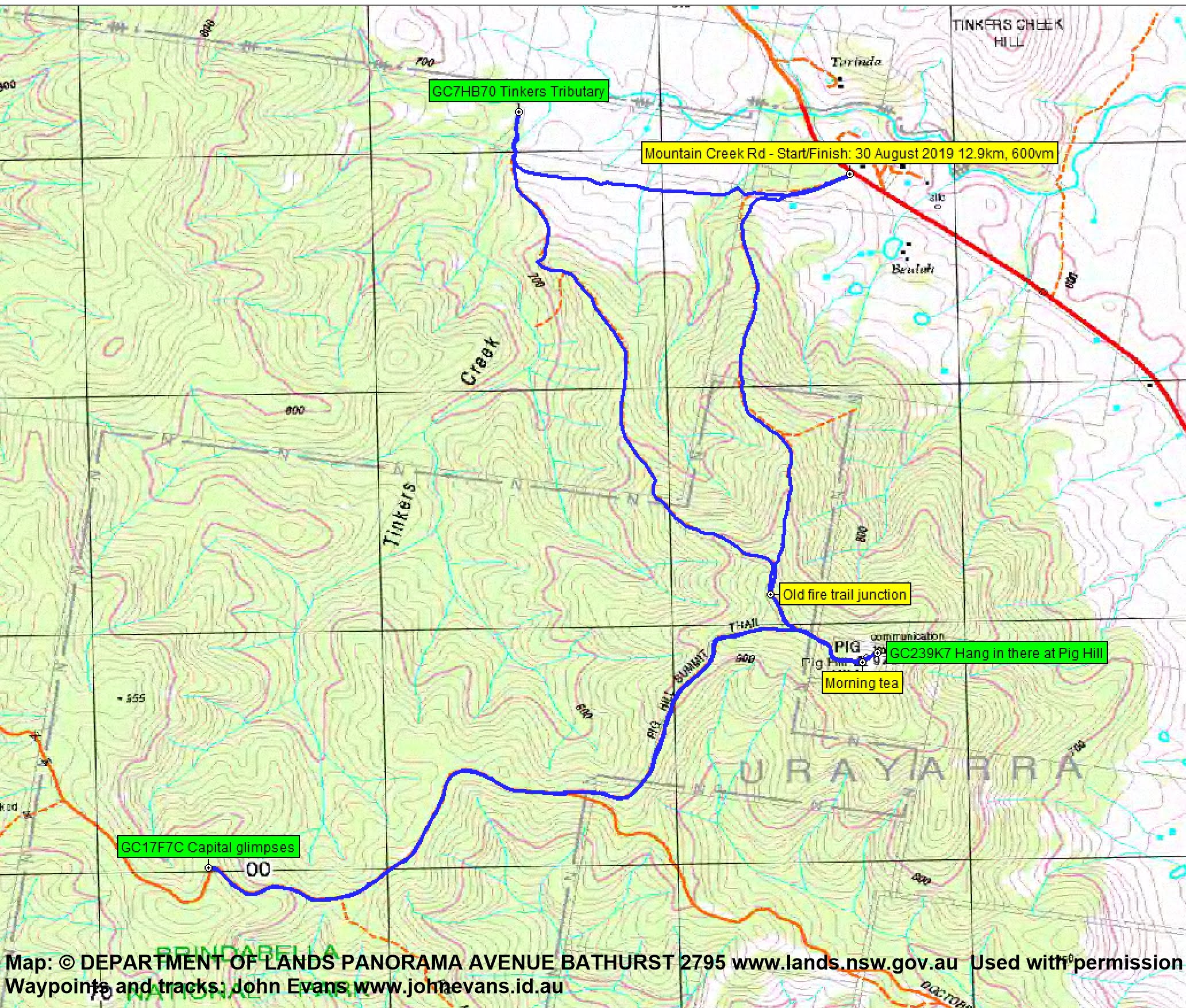
Distance: 12.9km | Climb: 600m | Time: 8.03am – 11.35am (3hrs 32mins), including 10 mins of breaks | Grading: M/E; M(9)
Photographs
Photographs are available, where you can start a large sized slideshow.
Waypoint and Track Files
Download the gpx file for this trip (if your browser does not automatically download the file, it will open the gpx file in a new window and you can then save it). To use in Google Earth, do File, Open… and select Gps or All files as the File Type.
Track Notes
It’s been more than 8 years since I’ve been in this area of BNP. Aware that Doctors Flat Rd has been locked off where it passes through private property, Roger had diligently search out a public access route. We used the Tinkers Creek Travelling Stock Reserve, starting from the side of Mountain Creek Road where it is signed.

Tinkers Creek Travelling Stock Reserve signage on Mountain Creek Road
From there, we walked west and a bit north to the location of a geocache.
Now what’s even better than having the cache owner with you to find a cache? It’s having his permission to replace a lost cache after a few super-cachers had registered DNFs. Roger pulled the replacement container from his pack, signed us on and placed the new GC7HB70 Tinkers Tributary.
Our next leg was a long pull up the Tinkers Creek Fire Trail SSE up to the junction with the Pig Hill Summit Trail. We wisely chose to head SW via the Trail and Doctors Flat Rd to the next cache. We passed one of the blocked off Doctors Flat Rd sites.

Doctors Flat Rd blocked at junction with Pig Hill Summit Trail
A further couple of kilometers each way for an easy find and log of GC17F7C Capital glimpses. There were only a few glimpses – trees are growing up.
Returned back along Doctors Flat Rd, passing a shapely telecommunications container.

Partially melted communications marker beside Doctors Flat Rd
Continued back up the signed Pig Hill Summit Trail.

Pig Hill Summit Trail signage at the blocked Doctors Flat Rd
Puffed up to Pig Hill. A nice view to the Tidbinbilla Range from the bottom.

View to the Tidbinbilla Range from the bottom of the Pig Hill Summit Trail
A quick find of GC239K7 Hang in there at Pig Hill.
Nice views for morning tea, but the wind was blowing chilly so it was a short stop.

Vista from Pig Hill
Roger had a little surprise up his sleeve – a nice variation to get back to the car via a disused fire trail.

Exit trail
On the way home, we stopped at the NSW-ACT border for me to log GC4M91K Tribute Cache 01 – City Gates – Fairlight Road.
Nice one, and home for lunch. Thanks Rog.
Track Maps
Track
Profile

Party
2 walkers – Roger E (Marmaduke Rothschild) (leader), me (JohnnyBoyACT).