Track Granite Tors Walking Track Upgrade on © 2017 map
Thursday 28 March 2024: Granite Tors Walking Track * – M/E-M. The Granite Tors Walking Track has been upgraded, as announced on the ACT Parks and Conservation Service Facebook page on 4 March. I’m time poor atm so propose a quick out there, up there to have a look and back. Around 8km and 420vm., ~3hrs walking. Just see 6:48am, Sunrise 7:13am.
Summary
From Garmin Connect (recorded on Epix Gen 2) – Distance: 9.47km | Climb: 414vm (Elev Corrections Enabled)/ 462vm (Elev Corrections Disabled) | Time: 2:27 moving +0:48 of stops = 3:15 | Grading: M/E-M; M(8).
From Garmin Connect (recorded on MAP66i) – Distance: 9.21km | Climb: 405vm (Elev Corrections Enabled)/ 471vm (Elev Corrections Disabled) | Time: 2:27 moving +0:48 of stops = 3:15 | Grading: M/E-M; M(8).
I can explain the different distances recorded on the two devices. The Epix Gen 2 recorded 2862 track points, the MAP66i 1028.
For the climb, you can choose from 405-414-462-471. Am I correct in assuming elevation gain is calculated via GPS signal, then calibrated somehow via different Digital Elevation Models (DEM) in the Garmin Connect app, selected by Elev Corrections Disabled/Enabled? Who knows? Who cares? Only me wanting lower hills to walk up.
Photographs
View photographs here.
gpx file
Download the gpx file here.
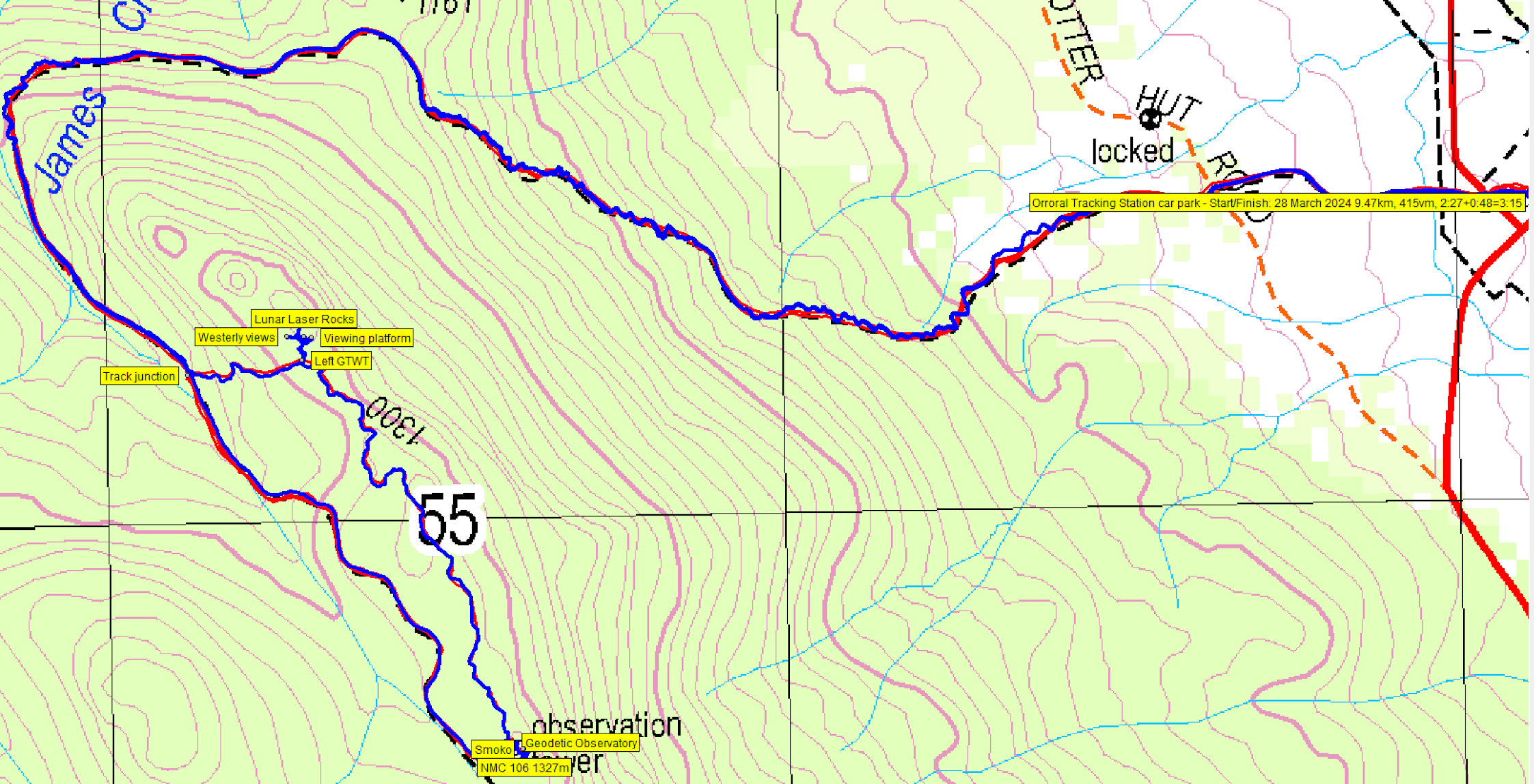
Track Map
Here’s where we went. This is from a ©2017 map.
Track Granite Tors Walking Track Upgrade on © 2017 map
Trip Report
I was last on the Granite Tors Walking Track on 2 Dec 23. I was last geocaching on Lunar Laser Rocks on 6 Jan 15, logging GC1H4D6 Teddy Bear Picnic.
We met in the Lanyon Valley at 7.00am and motored to the Orroral Valley Tracking Station car park. An abundance of roos.
Walking by 7.45am up the track to cross Cotter Hut Road. It wasn’t long before we struck the new work.

New GTWT work just after crossing Cotter Hut Rd at 970m contour
The new alignment closely follows the old, as you can see from the blue and red tracks on the above map segments. It wanders from side to side, lessening the steepness of the climb and better handling rain runoff. Really very pleasant.

The old alignment will gradually grow over
The only unhappy hikers might be those who don’t like steps.

Nice work at 1130m contour
The bend in the old alignment at James Creek is a little harder to recognise, so my “wait for me at the sharp left-hand bend” didn’t make much sense.
Three of the party had not previously visited the Geodetic Observatory, so that was a bonus. 4.4km in 1 hour 20 minutes. We had a poke about inside, then went to the railed area at NMC 106 for the views and smoko.

Sun breaking through over Orroral Valley from NMC 106
We set off again, NW along the GTWT ridge.

Nice passageway
It’s delightful walking, a favourite of mine.

Track takes a left
There are some massive tors approaching the southern Lunar Laser Rocks (so named in the ANUMC 1970s book ACT Granite).

Massive tors
At a point easily recognised by the hanging boulder, there’s a vague pad leaving the GTWT. Dick said that there were some great views, so we went to explore.

A vague pad leaves the GTWT and heads towards Lunar Laser Rocks
Grand views to the Orroral Valley. Slow thoughts in my mind until I realised I’d been geocaching here 9 years ago.

Orroral Valley from the upper viewing slab
We moved to a more open slab a bit to the West. Again, excellent views, this time up to Orroral Hill and the features on the ridge running NW from it.

Orroral Hill and the ‘rabbit ear rocks’ from ‘Westerly views’
Turning back, we visited the lower East facing slab.

A better view of Orroral Velley from the lower viewing slab
Many thanks Dick for taking us to these extra areas.
Back to the GTWT, we walked downhill to rejoin the old service road beside James Creek. There are a couple of extra guide posts I think.

A few new track markers on the ridge portion of the GTWT
All that remained was to trundle down to the cars.
Thanks folks! A good look-see at the new track work and a new walk for some of the party.
inReach Message Testing
Mike had a Garmin inReach mini with him and I had my Garmin MAP66i handheld. So we tested messaging, mimicking the situation where neither party has mobile phone reception. To communicate successfully you need:
- to have the inReach address of the recipient (you can’t message to an email address or phone number because there is no mobile phone reception. My inReach address is jevansact@inreach.garmin.com . I assume the first part of the address is taken from the email address you register with your inReach plan
- the recipient has to Check Mail on their device. If they don’t, no message will be received on the device!
So you have to set up the Contact and Check Mail.
Party
6 walkers – Mike B, Mike B, Dagmar K, Dick M, Charity M, me.
AllTrails
The AllTrails map is here, where you can pan and zoom.
Johnny Boy’s Walkabout Blog FaceBook Page
I’ve started up a FaceBook page. Each trip report posts to it. It’s another way to get some info to get out and breathe a bit of fresh air. Why not pop over and Follow the page, or give a post a Like.
Mike
28 March , 2024 5:59 pmI think Mike B needs to change his name so I know if I was on your walk. Mike B🙂
Johnny Boy
28 March , 2024 6:01 pmIs that Mike Bre… or Mike Bre … talking 😂?