
Majura Survey peg
Sunday 25 September 2022: Mt Majura and Justice Robert Hope Park NRs * – M/M-R,ptX.
Mt Majura as you may not know it. Climb 70vm up a rocky gully, rather than use the track. Search west down an old fence alignment looking for a survey post. Walk down a steep fire trail to the south-east corner of the nature reserve. Then climb very steeply north-west up a gully to Mt Majura (bright walkers usually ascend spurs). This off-track section rises over 200vm in 540m across the ground. From the trig, take the Majura northern spur though lovely Kurrajongs to the stone boundary wall. Follow it down to the north. Descend directly west to a tree blaze. The final leg is an off-track zig-zag south along the lower flank of Mt Majura, searching for any old grazing sites. Cross Antill Street and stroll through the woodland of the Justice Robert Hope Park. Who was he? Around 12km and 650vm climb.
Canberra Nature Park – a breath of fresh air for busy walkers. There are 39 Nature Reserves in the Canberra Nature Park. How many can we walk in? These are numbers 26 and 27.
Summary
From Garmin Connect – Distance: 10.78km | Climb: 651m | Time: 3:08 moving + 1:53 of stops = 5:01 | Grading: M/M-R,ptX; M(10).
Photographs
Photographs are available here.
gpx File
The gpx file is available here.
Track Notes
I was last on Mt Majura on 10 Jul 22 and did a quick recce of Justice Robert Hope Park NR on the same day. Since that time, I’ve had a lot of help from folk in attempting to identify some sites (see later).
We met as planned and wandered up the main track. At the bend in the track at the bridge we scrambled up beside the gully. It took me 13mins to cover the 220m across the ground and 60vm climb. I rejoined my companions at the top!

Climbing up beside the main Majura track gully
Although close to the Mt Majura top, our route today was the long way round, so we retreated down to the sheep camp junction.
The next task was to find a survey peg, mentioned to me by Waltraud Pix of the Friends of Mt Majura. He had a photo, but had lost the location except for a map of an old fence line that helped to locate the peg. Greg Hutcho (see his great blog for lots of great information, including every track and footpad on Mt Majura and Mt Ainslie!) interpreted the map for me. So we set off down the old fence line alignment.
“For such a time as this” (Esther 4:14), we had surveyor Mike L in the party. As we descended beside the old fence, he commented that a certain dip in the terrain would be just the place for a survey mark to be positioned. Sharp eyed Jacqui spotted it immediately!

Majura Survey peg
Majura Survey peg
Hopefully Mike can sus out a bit more info on the survey peg‘s purpose (hint, hint). So the day was over for me.
We went back up to the sheep camp junction, then down a steep fire trail to the east. Around the SE flank of Mt Majura for a bit, then N-ish to the bottom of our climb.
With bright walkers leading and me at the rear, we skirted well up from the gully for the ascent.

Majura Pines from around half way up the climb to Mt Majura
It took me 40mins to cover the 674m across the ground and 220vm climb to pop out on the Mt Majura Road and rejoin my companions.
We stopped at the Majura trig (quadruped, not quadriped, says Mike), who also explained Ecces and additional trig markers to me).
Continuing to chat as we moved on, I slipped off the crest of the NW spur and missed ‘Little Mt Majura’, but no matter. We hit the S end of the stone boundary wall and post and rail fence and wandered down beside it.

Majura stone boundary wall and fence

Majura stone boundary wall and fence
At the northern end we wandered down through the thin vegetation and stony soil to hit the fire trail, then round to the blaze tree. Here Mike gave us a great explanation of how survey blazes are made. More info to come (hint, hint again)?

Mike explains a survey blaze
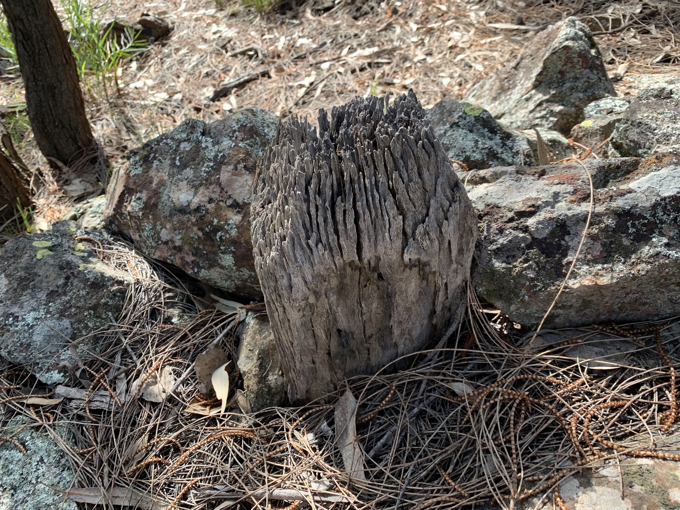
Next, down to the top of Clancy’s Track and down past the yards (or is it the stumps of a shearing shed?) and loading ramp.

Yards site or stumps of shearing shed?

Stock loading ramp
Our next search was for some limestone sites detailed in a paper by Doug Finlayson (some long time walkers will remember him), the paper provided to me by Mark Butz. There are 3 sites indentified in the paper – we visited an extra one, plus one of the identified sites.

Limestone

Limestone in dam wall
Cresting the dam, many of us saw a raptor sitting on a nearby post.

Raptor siting on post
It didn’t move as we approached! Closer examination, including of the string hanging out of its plastic base, revealed a geocache!
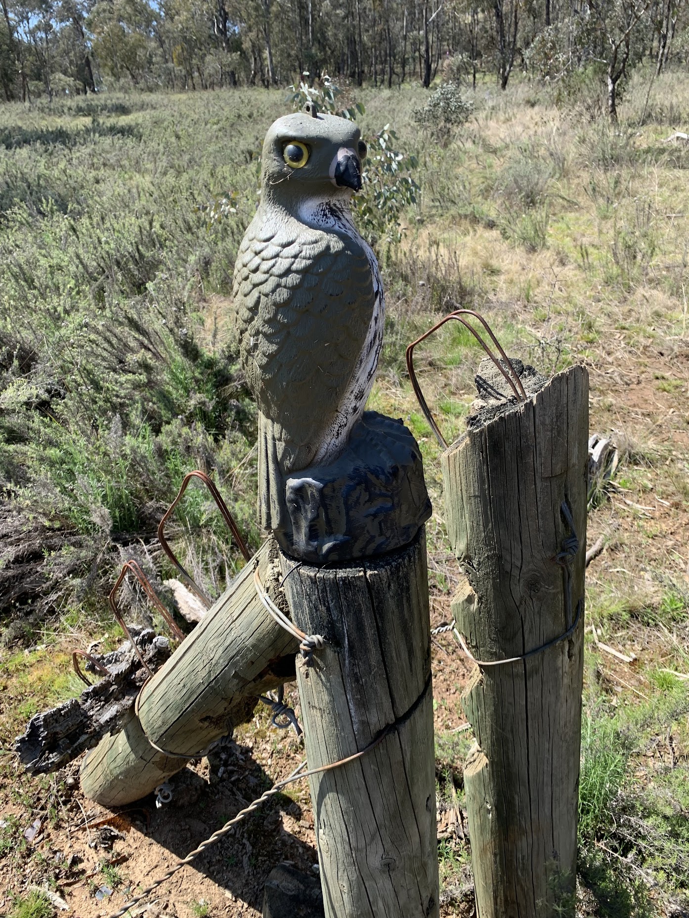
Nope, geocache
I can’t find it on the geocaching website, so it must be the final GZ of a multi or puzzle. I logged it anyway.
A few fences and gates as we headed across the Hackett Horse Paddocks, no more sites. The final fence on the edge of the main track was high, so we headed down to a gate visible near our cars.
Here, half the party left for afternoon engagements (we were a little later than I expected).
The rest of us took a wander through the little Justice Robert Hope Park NR. Cynthia did her homework on the fly, reading to us about Bob.
A nice dam.

Dam in JRHPNR
A nearby plaque.

Plaque commemorating a ‘Landcare Hero’
In a soak we visited, the noisiest frogs I’ve ever heard! Frog city.
Although Mike had left us, he’d also left another piece of interesting information. Ever noticed the lines of survey posts down the powerline easement? They’re used for the annual calibration of surveyors’ instruments!
Mike says: “You pretty well summed up the Watson Baseline where surveyors are required to calibrate their EDMs (electronic distance measurement instruments) every 12 months to prove they are still measuring accurately. There are 11 pillars there which we measure between and are checked against a highly accurate machine that conforms to the standards set out by the National Standards Laboratory in Sydney and traceable back to the essential Unit of Measurement.“

Survey instrument calibration area
What a great trip and new information. And CNP NRs #26 and #27 ticked off.
Track Map
Here’s where we went.
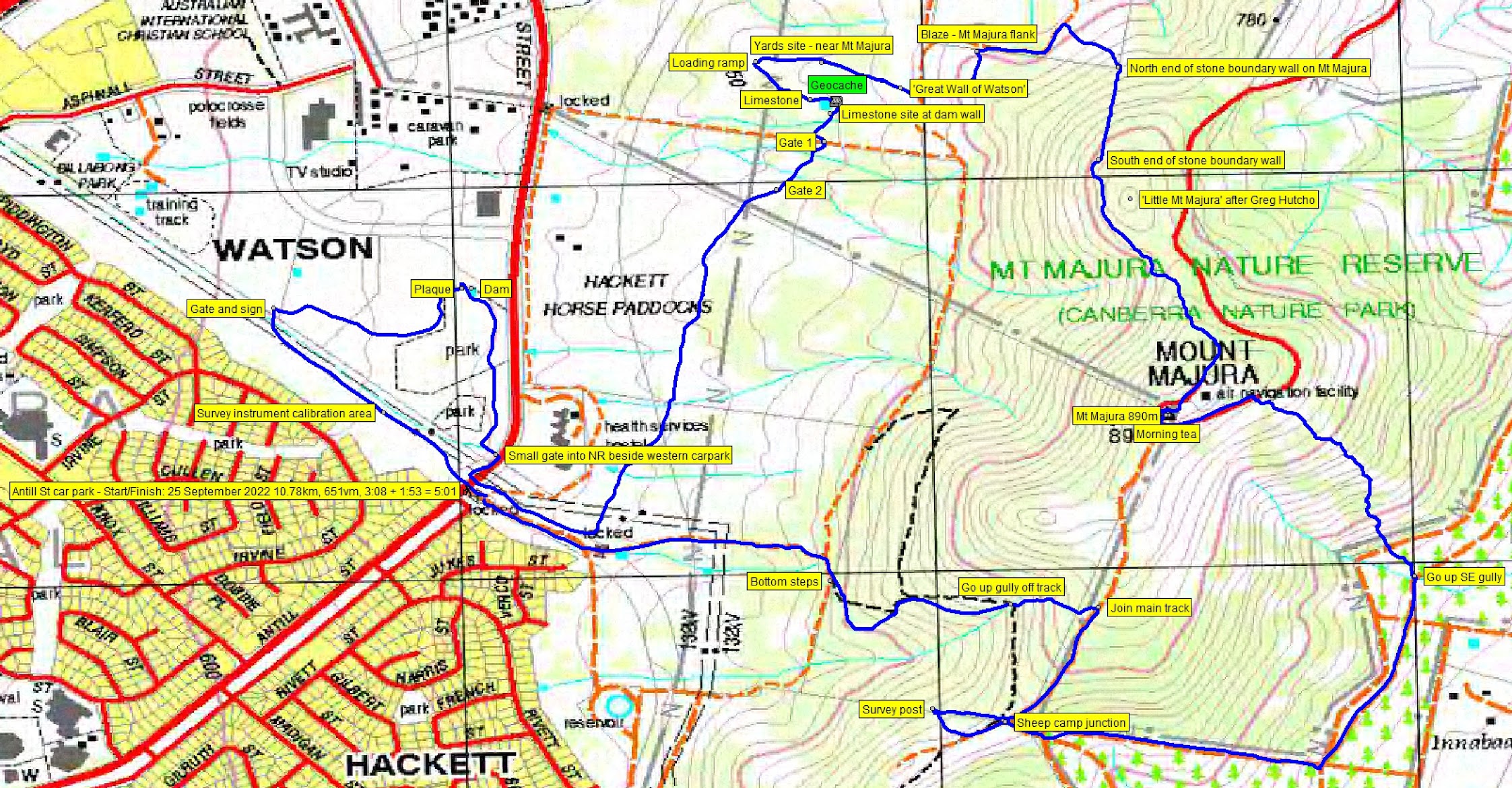
Track Mt Majura and Justice Robert Hope Park NRs
The AllTrails track map is here, where you can pan and zoom.
Party
13 walkers. Cynthia B and Chris R, Janet D, Terry G, Mike L, Ming L, Cameron L, Julie M, Wayne P, Jacqui R, Marie S, Khuong V, me.