Wednesday 23 March

Gungahlin Quartz Ridge
. Circumnavigate Mulligans Flat Nature Reserve. Visit 110 year old ACT border markers, the Dungarvon and Inglewood Homestead sites, the Wetlands, Gungahlan quartz ridge and the Woolshed. Around 14km and 250vm climb. Mostly management trails and footpads, a little off-track with long grass in places. BBC grade M(8), NPA ACT grade 2/A/B, CBC grade M/E-M. Meet at 8am in the Mulligans Flat car park off Amy Ackman St Forde (opposite Cleggett St).
Those doing their first Wednesday walk and also prospective walkers who are not members of the BBC, NPA or CBC clubs must contact the leader to discuss the level of difficulty of the walk.
Summary
Distance: 13.7km | Climb: 240m | Time: 3hrs 15mins moving time, plus 55mins of breaks |
Grading: M/E-M; E(7).
Photographs
Photographs are available here. And photos from 5 February
here and 25 January
here.
gpx File
Download the gpx file recorded via AllTrails
here (in AllTrails, activate …, Download Route, Select a file format, OK).
Another version of the gpx file, recorded on my Garmin Oregon 650 GPSr, is available
here. It has quite a few waypoints in it which the AllTrails version doesn’t, as in the map segment below.
Track Notes
AllTrails trip report.
Pretty much as in the walk description, with many photos from the previous two trips. We visited Stan’s Seat, the refurbished border marker E3 (Sheaffe-1) – just a square white peg, border marker I3 (Sheaffe-1) and the remnants of Border Marker U3 after being in the weather for nearly 110 years.
At the southern end of the Pipeline Track we called in at the
Dungarvon site, then SW to the
Inglewood site for morning tea.
Further to the SW on the ‘A Walk Through Time’ track, then a poorly defined footpad west to rejoin the predator-proof fence.
We stopped at the wetlands.

Walkers at the Mulligans Flat Wetlands
Out the Daisy gate and up to the Gungahlin Quartz Ridge. In the 1980s, the National Capital Development Commission published a ten volume series called Sites of Significance in the ACT. Many of the sites I’ve visited are listed
here. The Gungahlin Quartz Ridge is one of those sites.
A little whoopsie as I missed the Snake Gate, corrected, and we walked on north-ish to visit the Woolshed.
Our second echidna on the way.

Echidna
Back on the main E-W Mulligans Flat track, we exited via the Woodland gate and so back to the cars.
Track Map
The best track map is available via
AllTrails, where you can pan and zoom. But I’ve included our track on my old TopoView 2006 version of the area’s 1:25,000 map (no nearby suburbs existed then!), as it shows the various waypoints.

Track Mulligans Flat
Party
17 walkers. I hope everyone enjoyed the little trip. I think the combined clubs’ Wednesday Walks are important, as they maintain the social cohesion of the organisations’ members. You get two or three midweek walks to choose from too.
If you are interested in the history of Wednesday Walks, have a read
here.
Saturday 5 February

Wetlands dam and edge of Throsby from Gungahlin Quartz Ridge
. Circumnavigate Mulligans Flat, passing through a number of different vegetation communities. See 110 year old ACT border markers and walk beside the open grasslands. Check out the vestigial ‘Dungarvon’ site – imagine living here in the late 1800s. Visit the Wetlands and climb a gentle rise to a quartz ridge. Just about all the walk is on management trails and footpads, a short section of open woodland. Around 13km and 220vm, about 4 hours walking. Bring water and ‘munch’ (morning tea/lunch).
Summary
Distance: 14.25km | Climb: 248m | Time: Starting 8.15am 3hrs 25mins moving time, plus 50mins of breaks |
Grading: M/E-M; M(8-).
Photographs
Photographs are available here. And photos from 25 January
here, or below.
gpx File
Download the gpx file recorded via AllTrails
here (in AllTrails, activate …, Download Route, Select a file format, OK).
Track Notes
AllTrails trip report.
A trip pretty much the same as 25 January, described below. Except this time I got the SW route to the Wetlands correct and didn’t bother with any geocaches..
We entered via the Red Gum Gate, paused at Stan’s Seat, and headed up to the northern boundary of Mulligans Flat which is the ACT-NSW border. Had a look at a couple of the extant border markers, but most in this area (including all the blaze trees) are long gone. Nice views down through the woodland area.
Turned south down the Pipeline Track, with the flat and more open Mulligans Flat grasslands to our west. Went out the Bustard Gate and had a look around the
Dungarvon site. Some small, hard quinces on the trees but no sign in the long grass of the building site.

Walking back from an inspection of the Dungarvon site
Back inside the fence we continued west for a while, I got back on the right track and this time we stayed inside the fence and headed SW towards the Wetlands dam. A small mutiny at around 10.45am, walkers wanting to stop for morning tea. We took a break a few minutes later by the side of the dam.
Walked half way across the dam wall to get a view up its extent.

Wetlands dam
We exited the Daisy Gate and made the gentle climb up to the Gungahlin Quartz Ridge, and area designated in the 1980s NCDC publication
Sites of Significance in the ACT as site GH24. To me, this is the most beautiful area of the Reserve.

Gungahlin Quartz Ridge
Down off the ridge, we reentered the sanctuary area via the Snake Gate and followed management tracks to the Woolshed. I didn’t realise that the toilets would be so popular!

Inside the woolshed
From here it was a quick leg back along the main E-W management trail, out through the Woodland Gate and back to the cars.
Thanks folks, trust you enjoyed it.
Track Map
The best track map is available via
AllTrails, where you can pan and zoom. But I’ve included our track on my old TopoView 2006 version of the area’s 1:25,000 map (no nearby suburbs existed then!), as it shows the various waypoints better than AllTrails.

Track map
Party
15 walkers.
I’ve been wanting to visit the Kinlyside Nature Reserve up the back of Casey. I counted roos for the ACT Government through the area a few years back. So I drove home via the area. Alas …

Kinlyside signage

The Wetlands, Mulligans Flat
. Walk near-ish the boundary of Mulligans Flat Nature Reserve, taking in some old favourite border markers across the north and the Gungahlin Quartz Ridge (an old ACT Sites of Significance record) in the SW, Around 12km and 200vm, say 4 hours walking.
Summary
Distance: 12.74km | Climb: 246m | Time: Starting 8.00am 3hrs 5mins moving time, plus 17mins of breaks |
Grading: M/E-M; M(8-).
Photographs
Photographs are available here.
gpx File
Download the gpx file recorded via AllTrails
here (in AllTrails, activate …, Download Route, Select a file format, OK).
Track Notes
AllTrails trip report.
A couple of surprises for each of us, including the walk planner.
We started up the gravel entrance from the car park and took the first track on the left (not going as far as the Woodland Gate). Through the Red Gum Gate and on a hundred metres or so we came to Stan’s Seat, a memoria to Stan Marks, a long time Canberra Bushwalking Club member who used to love walking in this area. It awaits a small plaque and then, I understand, CBC will have a walk including this site.
Stan’s Seat
A gentle climb on the management trail with three easy geocaches to find. We stayed outside the fence.
Up to the ACT-NSW border and we spied our first border marker E3 (Sheaffe – 1). It wasn’t an original but a new re-survey.

Border Marker E3 (Sheaffe-1) resurveyed
If you’re really into ACT border markers, the original surveyors used an alpha and a number to identify each border corner, as in A1, B1, C1, etc. Sheaffe started from Mt Coree. But he got a bit mixed up initially and used the same identification a couple of times, hence I labelled this one Sheaffe-1.
The next border marker we visited was I3.

Border Marker I3 (Sheaffe-1)
This is what it looked like in October 2009.

Border marker I3 – as it was in 2009
Quite nice views from this high northern border area down through the woodland.

View down into the woodlands from the northern border management trail
We jollied along for a kilometre or so until we came to border marker U3. Again, now and in 2009.

Border Marker U3 after being in the weather for nearly 110 years

Border marker U3 in October 2009
Here we turned south and walked the flatter part of Mulligans Flat.

Mulligans Flat is flat
Down just near the Bustard Gate we saw the exotic trees at the
Dungarvon site.

Exotic trees at Dungarvon site
From here I’d planned to bear away to the SW, but took a turn too early after passing through the Quoll Gate. Glad I did, as I surprised myself and the others (Brian saw it first) as we came to the
Inglewood Homestead site. I’d been here caching with Shell on my birthday in 2019.

Inglewood site
Nearby Peppercorn tree and a pear tree (with fruit) and a couple of new tables. Excellent signage.

Signage at Inglewood site
As we walked on, we found we were on the A Walk Through Time track.

A Walk Through Time signage
A Shingleback Lizard along the management trail.

Shingleback lizard
By this time my final objective was around 2km west of us, so we took a little detour along a fence line. The route is shown petering out on
AllTrails.

Fence line walking
Plenty of grass seeds to pick out of my unprotected socks. We eventually intersected with a management trail, labelled Mulligans South Trail on AllTrails. This took us to the edge of Throsby and a little viewing platform at the end of a ‘boardwalk’ coming from the suburb’s edge. In the direction we wanted was signage to the Wetlands Walk.

Wetlands Walk signage
In a little way was a magnificent dam.

The Wetlands, Mulligans Flat
With great signage.

The Wetlands, Mulligans Flat signage
At last back on my planned track, we climbed the gentle slope to the Gungahlin Quartz Ridge, a site in the 1980s NCDC
Sites of Significance in the ACT.
It’s a truly lovely area.

Gungahlin Quartz Ridge
With, of course, lots of quartz.

Quartz on the Gungahlin Quartz Ridge
A couple of stick shelters along the ridge, but how could one tell kids that they shouldn’t move the timber and disturb the residents.

Another stick shelter
We tracked N along the edge of Forde to near the Woodland Gate. A huge mistletoe.

Large mistletoe – the biggest I’ve ever seen
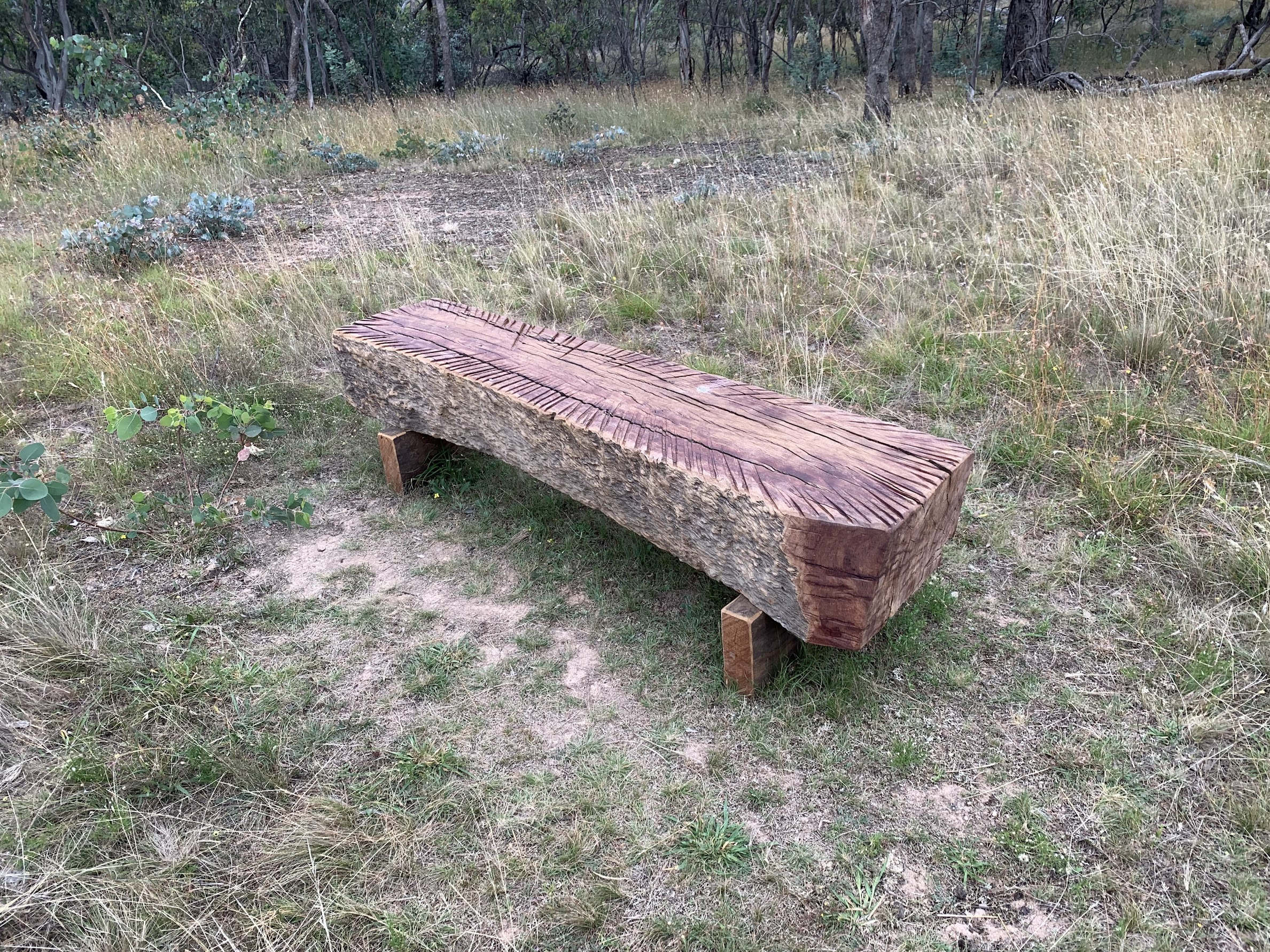
To cap off the walk, a tree with groovy markings.

Interesting tree markings
Track Map
The best track map is available via
AllTrails, where you can pan and zoom. But here it is.
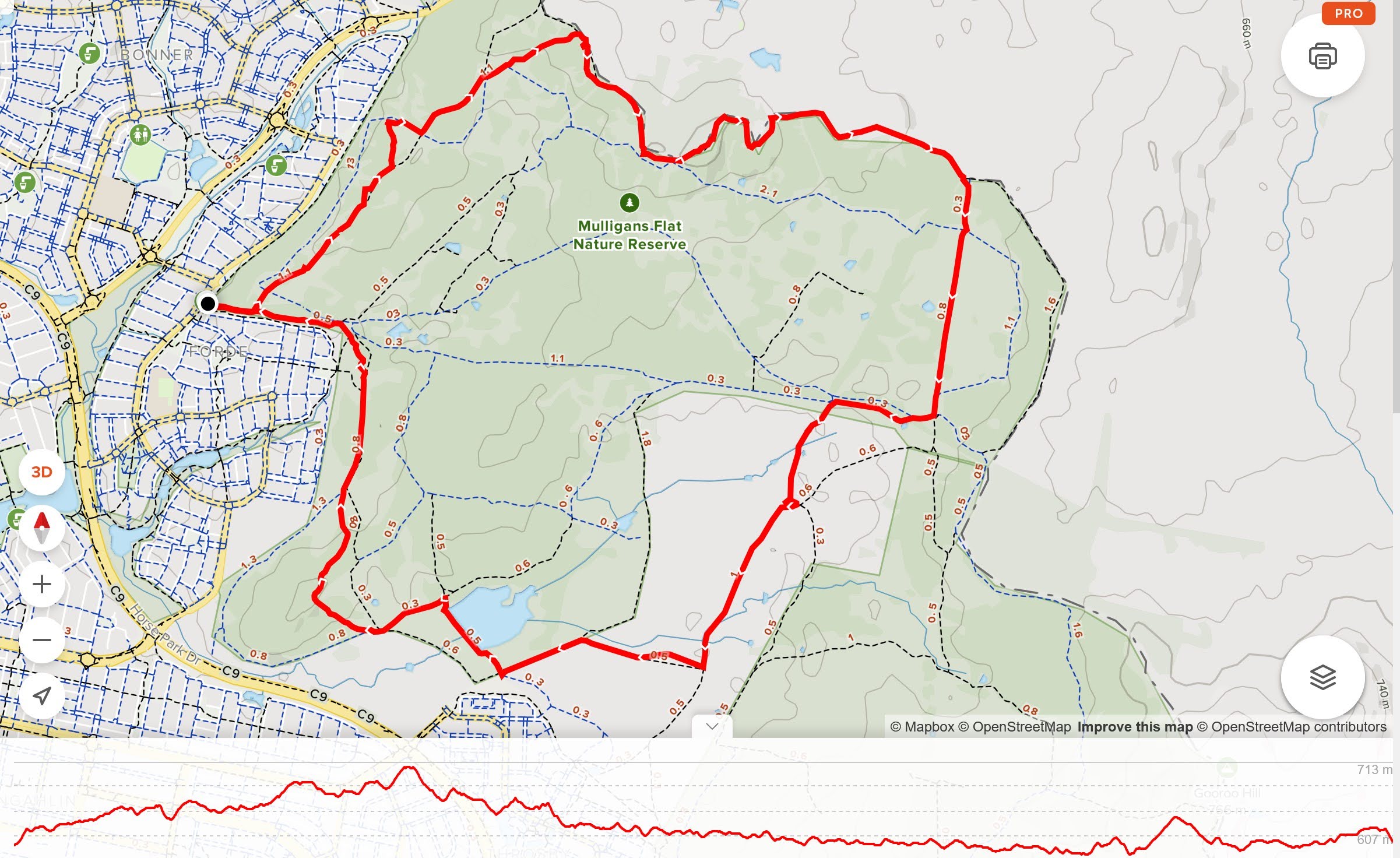
AllTrails Track Map with height profile
Party
Brian S, Phillip S (they were very patient), me.