
Blythburn Cottage
Saturday 22 April 2023: Blythburn Cottage * – L/E. The Blythburn Cottage area has a history dating back to before 1839. The current stone building was built around 1885. Elizabeth Julia McKeahnie established an all female dairy and cattle station there around 1900. With permission from the land owner, we’ll walk out of Namadgi National Park, down beside Punch Bowl Creek and through White Horse Flat to visit the homestead. To return, we’ll circle SH1035 on fire trails and climb back up to Corin Road. Around 17km and 700vm climb.
Summary
From Garmin Connect (Epix Gen 2) – Distance: 16.17km | Climb: 660m | Time: 4:01 moving + 2:02 of stops = 6:03 | Grading: L/M; M(11).
Photographs Photographs are available here.
gpx File The gpx file is available here.
Track Notes
I was last at Blythburn Cottage on 29 Aug 15. There is some information here.
12 of us met at Lanyon Marketplace at 7.30am and motored in 3 vehicles up Corin Road to the now gated off bottom of Smokers Trail. 4 more met us there.
Walking by 8.05am and wended our (long, shorter on return) way a bit up Smokers Trail and some other fire trails to the boundary of Namadgi National Park and the start of the Punch Bowl Creek footpad. A little dip down through a drainage line to get from the fire trail onto the footpad route.

Crossing a small creek between fire trail and start of Punch Bowl Creek footpad
Got onto the footpad and started the descent.

On the Punch Bowl Creek footpad
Quite steep (we certainly noticed that on the return leg) near Punch Bowl Creek Falls.

Better view into Punch Bowl Creek falls
Robert’s big camera does an even better job.

Punch Bowl Creek Falls | photo Robert W
I dislike navigating on fire trails, especially when they change after 8 years. A couple of map-marked whoopsies during the day.
Quite wet through the White Horse Flat area.
After around 6.2km and 1hr 50mins, we broke out onto the open pastoral land.

Breaking out onto pastoral land, Booroomba trig in the distance
A circuitous route to our objective, as we couldn’t tell whether the intervening country was boggy. A lovely entry.

Lovely vista approaching Blythburn Cottage
Beautiful mature trees at Blythburn.
A great spot for morning tea and a poke about.

Blythburn Cottage | photo Robert W
Thoughts on a different way home …

Harness up the sheep to get us home
… and flagstones in the separate kitchen building.

Flagstones in the kitchen building
We arrived at 10.20am and left at 10.50am, heading NW then W towards the flank of SH1035 and Punch Bowl Creek.
I found a fire trail at waypoint ‘On track’. We crossed Punch Bowl Creek, recovered from a little whoopsie, then I made a big one. A hundred metres or so of ‘quality’ bursaria scrub. But our two guests enjoyed it so much that they plan to join CBC.

Emerging onto a fire trail from the ”Quality’ Bursaria’
Always happy to admit my errors, so that I and others might learn.

Snip from Google Earth
How did this happen? I plan trips by (1) looking at my old walks in the area (2) creating waypoints and routes in OziExplorer using, by default, a TopoView2006 NSW mosaic (3) running the gpx file through AllTrails to get the total ascent, as AllTrails has a good DEM (Digital Elevation Model). There is sometimes value in looking at old maps. In this case I should have looked at Google Earth or downloaded the current SIX e-topo Tidbinbilla map ©2017 and calibrated it for use in OziExplorer. Both show the fire trail near the ‘Quality Bursaria’ which I should have used.
A couple of kilometres of fire trail followed, some of it newly bulldozed.
We crossed Punch Bowl Creek and sat down for lunch.

Crossing Punch Bowl Creek at the lunch spot
Not Blue Gum Creek, but Punch Bowl Creek. Bursaria damage exacerbated by low-dose aspirin.
All that remained was a 2.6km puff back up beside the creek and a smarter (suggested by Sonja) return on the fire trails to the cars.
Either my memory is suffering, or there’s been a few changes. But the majority of the walkers had not been to Blythburn, so a good result.
A large party, but fine for fire trail stuff. Much chatter. thanks all!
Relive the trip
Track Map
Here’s where we went.
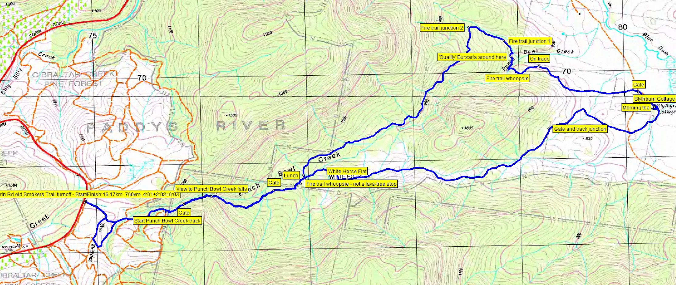
Track Blythburn Cottage via Punch Bowl Creek
The AllTrails map is here, where you can pan and zoom.
Party
16 walkers – Jenny A, Andrea C, Joyce De G, Teresa H, Austin K, Beatrice K, Bec M, Sal O, Lam S, Phillip S, Sandra T, Ana V, Khuong V, Robert W, Sonja W, me.
Johnny Boy’s Walkabout Blog FaceBook Page
I’ve started up a FaceBook page. Each trip report posts to it. So it’s another way to get some info to get out and breathe a bit of fresh air. Why not pop over and Follow the page, or give a post a Like.