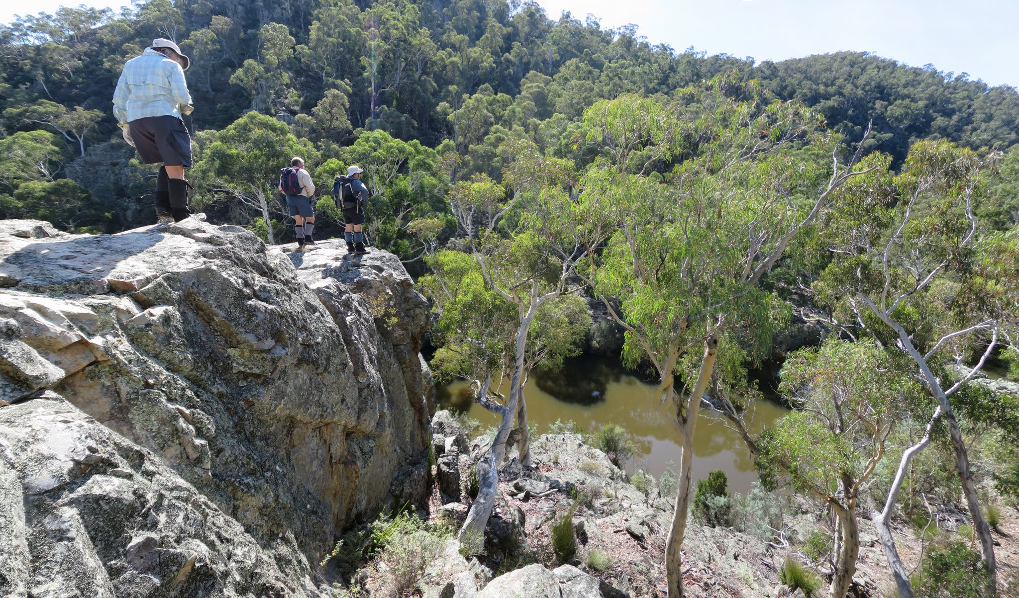
We join the Kybeyan River at a large bluff and pool
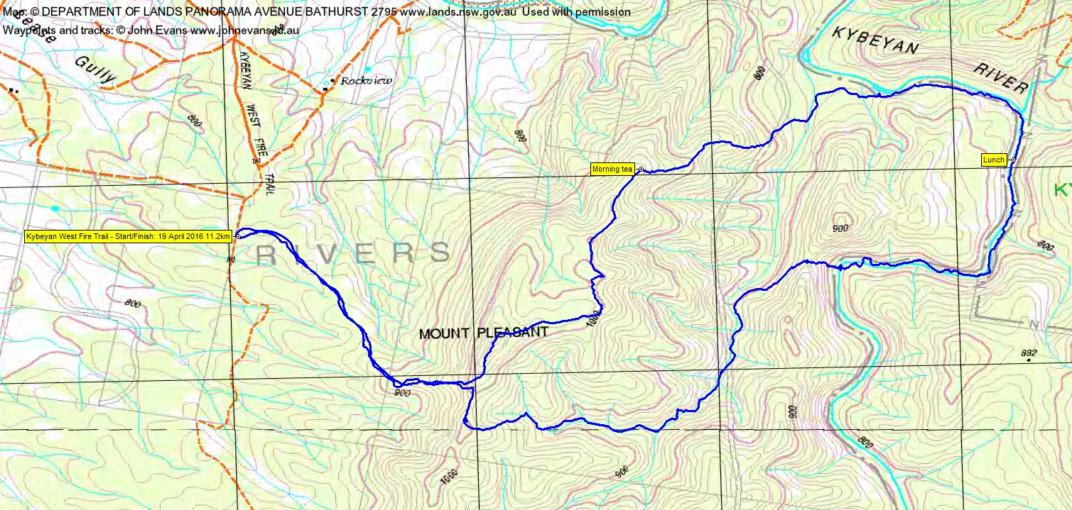
Tuesday 19 April: Mt Pleasant and Kybeyan Gorge – M/R. A circuit with a view point, a granite gorge and fairly open ridges. Park on the Kybeyan West FT at approx. 121 E, 868 N (GDA94) and walk up to Mt Pleasant (1050 metres). Descend the ridge to the north to the Kybeyan River. Upstream, rock hopping, for about 3 km along the river past bluffs and large pools; the pools have brownish water like the Shoalhaven, then return via ridges to the cars. ~ 13 km, total ~ 530 m ups and downs. Road access crosses private property for which permission has been obtained. A 1hr 40 min drive from south Canberra. Leader: Linda G. Maps: Numerella, Kybeyan. Transport: $20 per person.
13 of us drove in 3 vehicles to park beside the Kybeyan West Fire Trail. Monaro Highway to just before Cooma, Polo Flat Road, then Cooma Numerella Rd through Numerella, right into Warrens Corner Rd, left into Kybeyan West Fire Trail. Met 7.15am in Hume, walking by 9.10am.
Further Information
This walk was just to the north of 5 Aug 14.
Summary
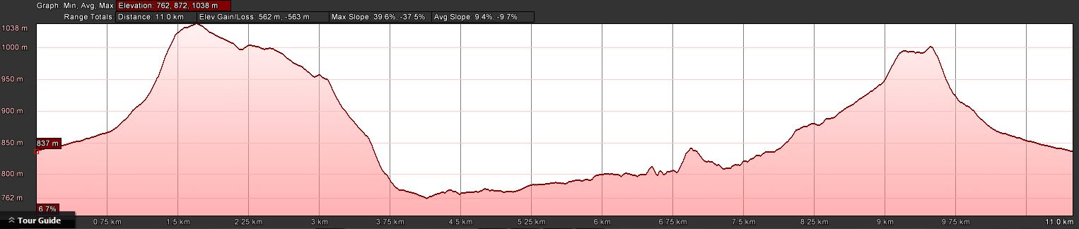
Distance: 11.2km | Climb: 560m | Time: 9.10am-4.00pm (6hrs 50mins), including 60 mins of breaks | Grading: M/R; M(10)
Photographs
Photographs are available, where you can start a large sized slideshow.
Waypoint and Track Files
Download the .gpx file. (Right click, Save Link As…, Save – if you want to use it.)
To use in Google Earth, do File, Open… and select Gps or All files as the File Type.
Track Notes
A gentle start up through Scribbly Gum open woodland, then a steep climb to the Mt Pleasant feature. Views to the fog-bound valley to the West. Gently down a NE spur, then a forced way for 10 minutes though thick Acacia nana at the 1000m contour. A descent further down the spur to the NE to morning tea. 3.1km in 1hr 25mins.
More easy walking generally NE down towards the river. We walked a bit of a dry creek at one stage, then curved a little East to join the Kybeyan River at the top of a bluff, with a pool below in the river. The river walking was a combination of some gentle scrambling and easy walking along sandy banks. The river took a right-angled bend to the south and we found a long lunch on rock shelves. Morning tea to lunch was 2.3km in 1hr 20mins.
The gorge continued south, then took a sharp turn to the west. A water dragon and some cliffs and bluffs to appreciate. A crossing, then back, as we neared the point where we were to leave the river. A stiff climb of 60 vertical metres took us to a saddle on the crest SW of the 900+m feature. From here we sidled down through dry going to the dry creek line we’d crossed earlier in the day. This leg from lunch 2.2km in 1hr 20mins.
We followed the dry creek up for 1.5km, walking mostly in the creek. At one stage a stray dog, collared, joined us. We were later to find out from a farmer who stopped as we were packing up at the cars that the dog had gone bush a couple of days earlier. This leg took 50mins.
Finally, it was another climb up to the Mt Pleasant southern spur, a bit north to join our inward track, then the steep then gentle slope back to the cars. Easy walking coming down. This leg 2.1km in 55mins.
Every walk is a good walk and a walk in an area not usually frequented is even betting. We trust that Ibrahim, doing his second ever bushwalk, enjoyed the day. Thanks Linda.
Track Map
Track
Profile
Party
13 walkers – Melinda B, Peter C, Eric G, Linda G (leader), Ibrahim H, Ian H, Barry K, Terrylea R, Phillip S, Brian S, Lorraine T, Ian W, me.
Next Tuesday Walk
Tuesday 26 April: Nadgigomar Nature Reserve, Eastern Section – M/R. The walk starts on the Mogo Road and is off-track in undulating terrain. The reserve contains one of the best remaining old growth woodlands on the southern tablelands and some small swamps. There is a 1 hour 40 minute drive each way. Minimum distance: 17 km with 150 metres of ascent. Map: Oallen. Leader: Ian W. Transport: 224 km return Limit: 8.