Kybeyan River bluff

Tuesday 5 August: Kybeyan Ridges and River – M/R,ptX. A circuit in the Kybeyan SCA, to explore the ridges and river upstream of the April walk in this interesting area. Start ~ 121 E, 868 N, then via saddle at 129 E 857N (Numeralla map), south then east down to a winding section of the Kybeyan River which has, according to Google Earth, bluffs and sandy beaches at 142E, 845 N (Kybeyan map), return by a different ridge. 1 hour 40 minute drive via Numeralla. Around 13 km, main height changes are: up 250 metres, down 350 metres before lunch, reverse in the afternoon. The drive crosses private property for which we have permission. Maps: Numeralla, Kybeyan. Leader: Linda G. Transport: $100 per car. Limit: 10.
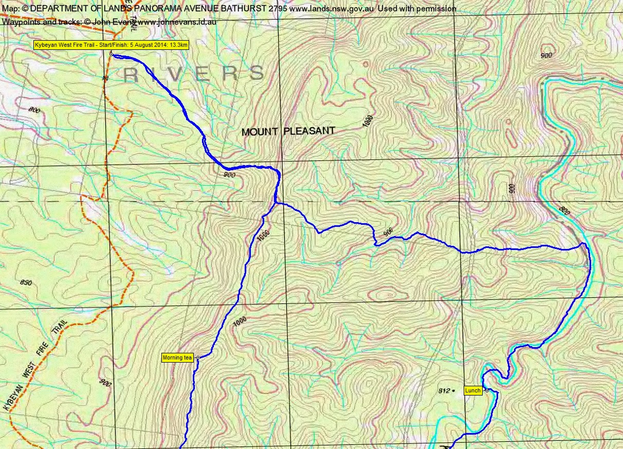
8 of us drove in 2 cars via Cooma and Numeralla to park on the Kybeyan West Fire Trail.
Summary
Distance: 13.3km | Climb: 630m | Time: 8.55am-3.15pm (6hrs 20mins), with 50 mins of breaks | Grading: M/R; M(11)
Track Maps
Track overview

Track 1
Track 2
Photographs
Photographs are available, where you can start a large sized slide show.
Video
Google Earth
Download the Google Earth .kmz file here.
Track Notes
-8°C and the coldest morning in 15 years as we left Canberra. -10°C in Cooma where we were heading. But it wasn’t too bad at 840mASL and just before 9am when we got underway.
In fact, the layers came off as we climbed, first gently, then steeply, to the crest of the ridge at a saddle south of Mt Pleasant at 1000m. Up to the first knoll and we’d completed the stick of our lollypop walk (same entry to here and exit from here, the remainder of the day being a round). Lovely open, dry sclerophyll woodland made for easy walking, apart from the climb. 1.6km in 30mins.
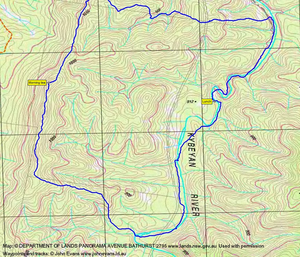
The ridge took us south. Knolls and dips made for interest, with the crest becoming knife-edge in places. Huge views west over the Numeralla River valley to the distant snow-capped Main Range – we could see from the Rams Heads in the south to Mt Jagungal in the north. Spectacular! Morning tea was enjoyed on one of the knolls. The ridge top leg was 2.4km taking 1hr 15mins (including 15mins of morning tea).
Here we bent away just south of east down a convenient spur. The going remained the same. At the bottom we crossed a gully system, then skipped across the first of 8 crossing of the Kybeyan River. 1.5km in 33mins.
To our surprise the close-by first pool in the river was iced over and we spent a few minutes skimming stones across it.
The river banks were also easy walking, generally open flood levels beside the main river course. A couple of rather spectacular bluffs caused us to either cross to the other side or work our way around the bases. One of the best was just before lunch. Passing it, we crossed back to the true left bank at a rock ribby area to find a delightful lunch spot in the sun. Walking the river, it was t-shirt weather. This leg along the river 2.3km in 1hr.
Having recently been introduced to crowlometres (crow = straight-line + kilometres), today’s terminology was a t-minute. This is the time it takes Eric to drink a cuppa, without having to throw any out due to a hasty restart.
More bluffs and pools immediately after lunch. One might suspect that, as something has made the river twist and turn in this area. Finally back on the car side of the river, our noble leader even gave us a choice of routes. We chose another length of easy flood-level walking before we had to say good-bye to the river. From lunch to leaving the river was 1.6km in 50mins.
A 190m ascent to the ridge made us huff and puff a bit, then down (some through a patch of nana – Allocasuarina nana (Dwarf She Oak)) to a pleasant gully that we wandered up for a while. Leaving it, another 100+m ascent to the morning’s crest, joining it at the top of the lollypop stick. This leg 2.2km in 1hr 10mins.
Retracing our inward leg, 1.7km in 32mins, we were back at the cars.
This was a very, very nice walk. The combination of ridge and river, with knolls, bluffs and iced pools thrown in, through generally open going, was perfect.
Party
8 walkers – Mark B, Peter C, Eric G, Linda G (leader), Stewart J, David O, Ian W, me.
Next Tuesday Walk
Tuesday 12th August: Nadgigomar Nature Reserve – L/M. The walk is in the eastern section of Nadgigomar Nature Reserve 35 km north of Braidwood. The terrain is flat or slightly undulating, with some low hills on the western boundary. There are extensive, mature, dry sclerophyll woodlands and forests and some interesting swamps that we shall visit. A fire has recently burned through some of the reserve and our route takes us in and out of burnt areas. The route is all off-track with only light scrub, except near the swamps. Emergency contact details must be registered/provided to book. Bookings by Friday 8th. Distance: 25 km with ∼300 metres of ascent. Map: Oallen Leader: Ian W. Transport: 225 km return. $83 per car. Limit: 8.