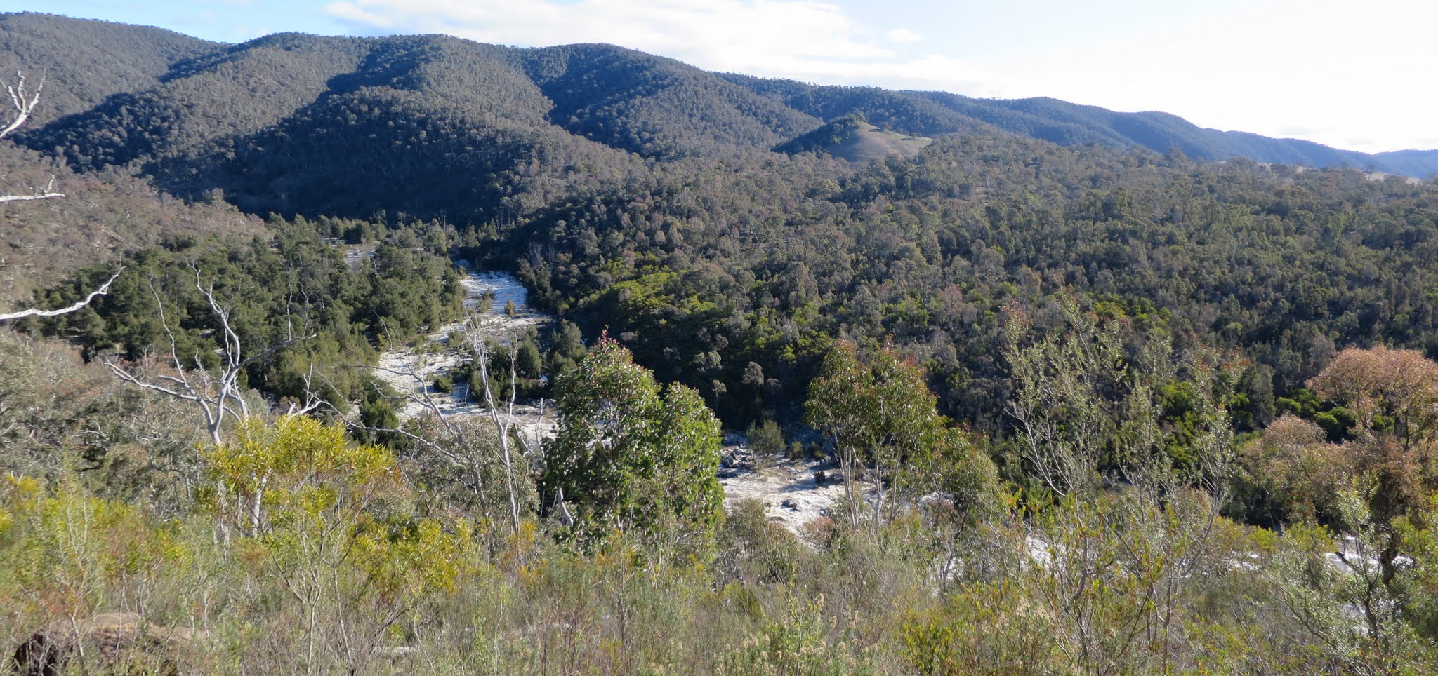
Murrumbidgee River round the corner north of Kambah Pool
Saturday 18 July: Cotter to Kambah, a Totally Topo! and geocaching event – M/E. Walk the Murrumbidgee River track from Casuarina Sands to Kambah Pool. 17 geocaches to find and 3 maps to walk on. Around 13km and 390m climb. Maps: Cotter Dam, Canberra, Tuggeranong. Leader: John Evans 0417 436 877 john@johnevans.id.au . Transport: ~$6 per person, car shuttle required.
7 of us met at Kambah Pool, then drove in 2 cars to Casuarina Sands car park at the Cotter.
Summary
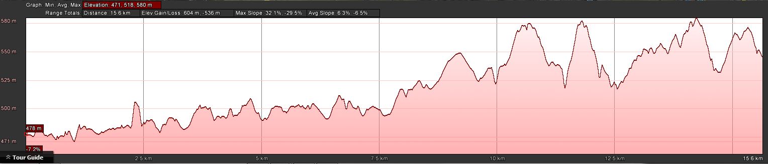
Distance: 16.0km | Climb: 600m | Time: 8.30am-3.10pm (6hrs 40mins), including 40 mins of breaks and lots of geocaching | Grading: L/E; M(10)
Track Maps
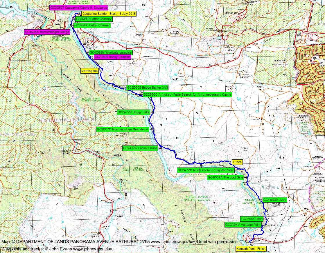
Track overview
Track 1
Track 2
Track 3
Profile
Photographs
Photographs are available, where you can start a large sized slide show.
Videos
Waypoint and Track Files
Download the .gpx file. (Right click, Save Link As…, Save – if you want to use it.)
Download the .kml file.
Track Notes
A very pleasant ramble up the Murrumbidgee River from the Cotter to Kambah Pool with new and old friends kind enough to make allowances for geocaching forays. Assistance from fellow cachers MikalStill and ChifleyGrrrl – and a find by muggle Quentin.
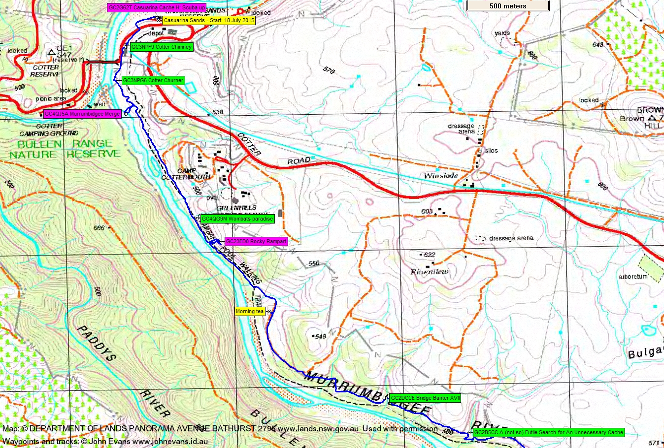
At our start, no joy with GC2G62T Casuarina Cache. Only a cursory glance as it’s always a fine balance between walking and searching/waiting. So we headed down the track for a bit, but then had to climb up and across the road to log GC3NPF9 Cotter Chimney. An interesting site, along with the nearby Cotter Pumping Station and signage. To the bridge and back onto the track.
The first thing we’d noticed was that the river was swollen and flowing swiftly. Down opposite the confluence of the Cotter and Murrumbidgee Rivers at the flume pipe there was plenty of white water. Cold in the shade. A quick find of GC3NPG6 Cotter Churner.
A closer look at the river a little further on. A couple of us were down on the bank within a few metres of GC4QJ5A Murrumbidgee Merge, but then read the cache warning: “This cache will not be accessible when the river is in flood!” It was obvious that we were not going to log it today.
The river was noisy company and we continued south under Camp Cottermouth and Greenhills. A few metres off the track we found GC4QG9M Wombats paradise, although it was a cool wait in the frosted shade for the non-cachers.
Next came GC23ED0 Rocky Rampart. It’s quite a nice looking rampart too and a huff and puff to climb up to it. But with everyone waiting below (where were you my fellow cachers?) I didn’t spend much time looking and came away with a no find. And I missed a couple of kayakers going down the river, in helmets and GoPros, so I’m told.
Another 700 metres down the track we found morning tea in the sun at 9.55am.
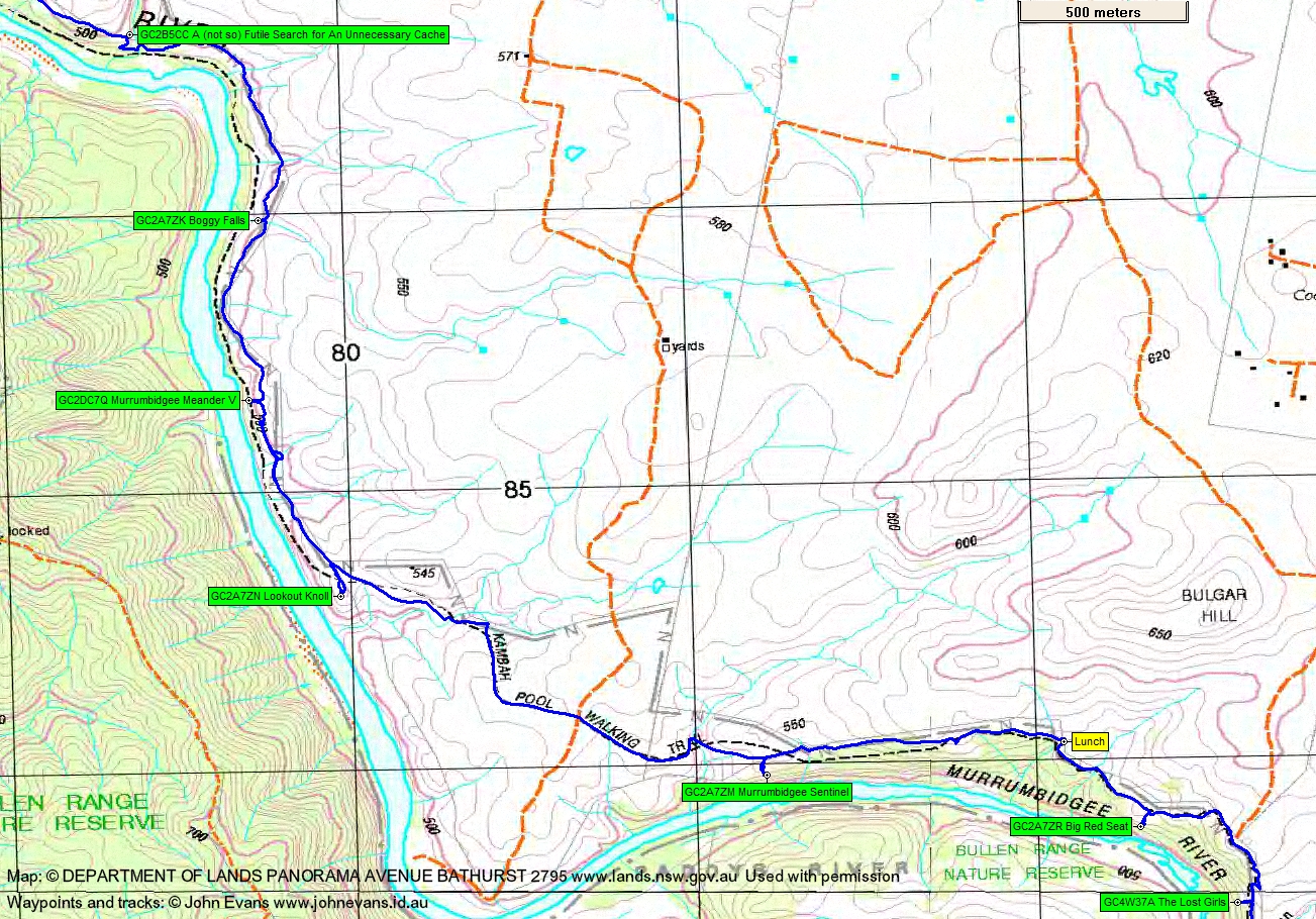
We walked a further 8km in 2hrs 45mins from morning tea till lunch and found and logged GC2DCCE Bridge Banter XVII, GC2B5CC A (not so) Futile Search for An Unnecessary Cache, GC2A7ZK Boggy Falls, GC2DC7Q Murrumbidgee Meander V, GC2A7ZN Lookout Knoll and GC2A7ZM Murrumbidgee Sentinel. Some of these caches took us a few tens of metres off the pleasant (but boring) track to some lovely rocky outcrops with huge views down to the river.
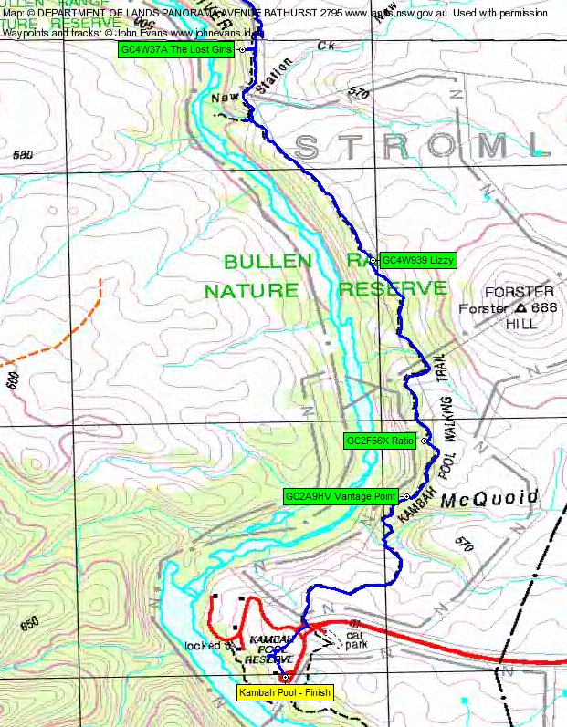
After lunch another fine run of caches found and logged: GC2A7ZR Big Red Seat, GC4W37A The Lost Girls, GC4W939 Lizzy, GC2F56X Ratio and GC2A9HV Vantage Point. I don’t think I’ve ever seen New Station Creek running before. Thanks to Q for finding the last cache which had eluded me on previous searches.
We took the modest path when we came to the junction “Kambah Pool via nudist beach”.
Another cracker of a Canberra winter’s day. Delightful except when in the breeze and early in the day in the shade. Thanks all.
Party
7 walkers – Jenny C, Cynthia C, Trevor L, Quentin M, Alison N, Michael S, me.
Next Saturday Walk
Saturday 25 July: Coronet Peak geocaches – L/R,ptX. Provided the weather is suitable, insert via the Australian Alps Walking Track from Orroral, then off-track up towards Coronet Peak. A cache on the way and another 500m to the south, if party members are interested. Return towards the granite cap and sidle west round its base to GC1M554 The Princess of Namadgi. Dinner with Rob and Jenny’s party at Pond Creek. Walk home in the dark. A long day at around 30km, 1300m climb and 10 hours walking. Maps: Rendezvous Creek and Corin Dam. Leader: John Evans 0417 436 877 john@johnevans.id.au . Transport: ∼$12 per person.