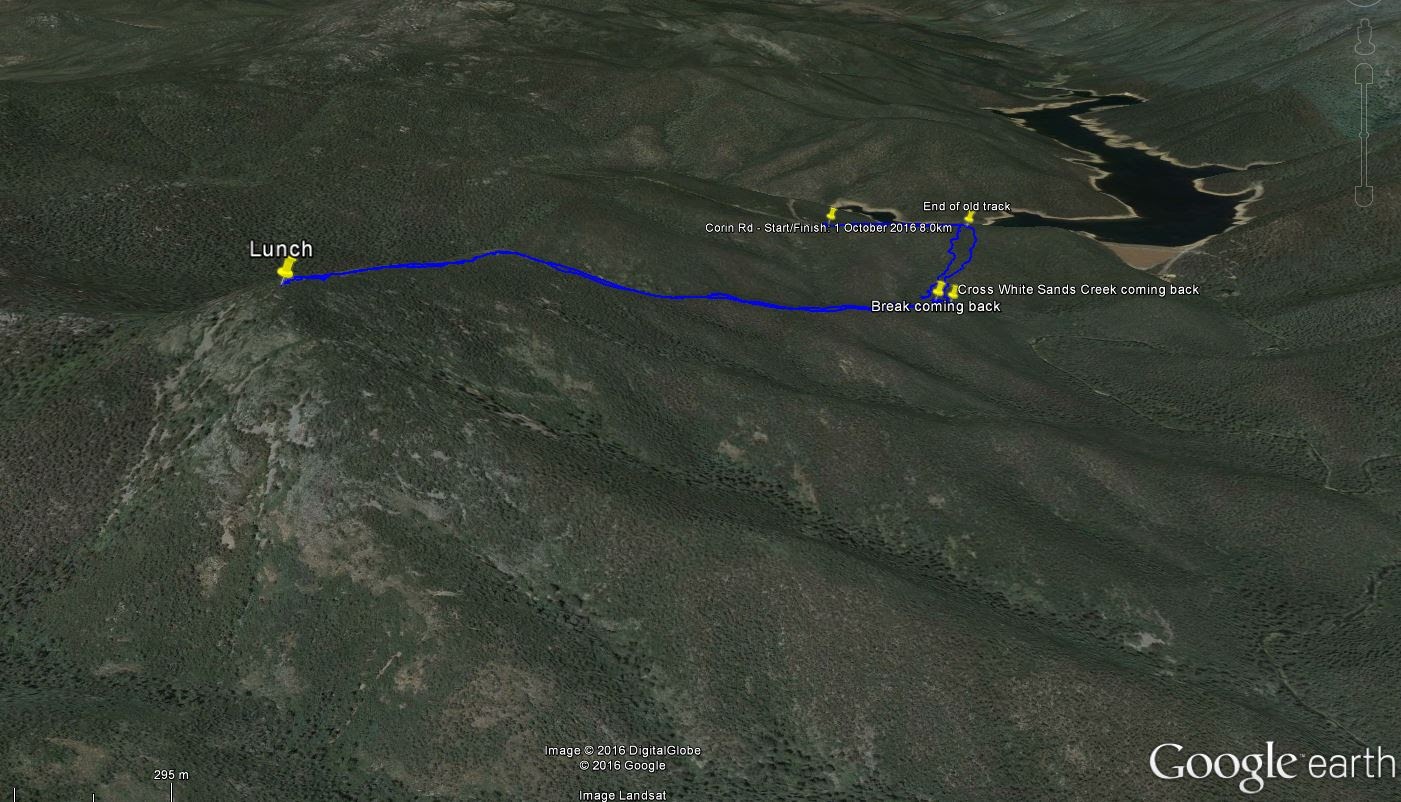
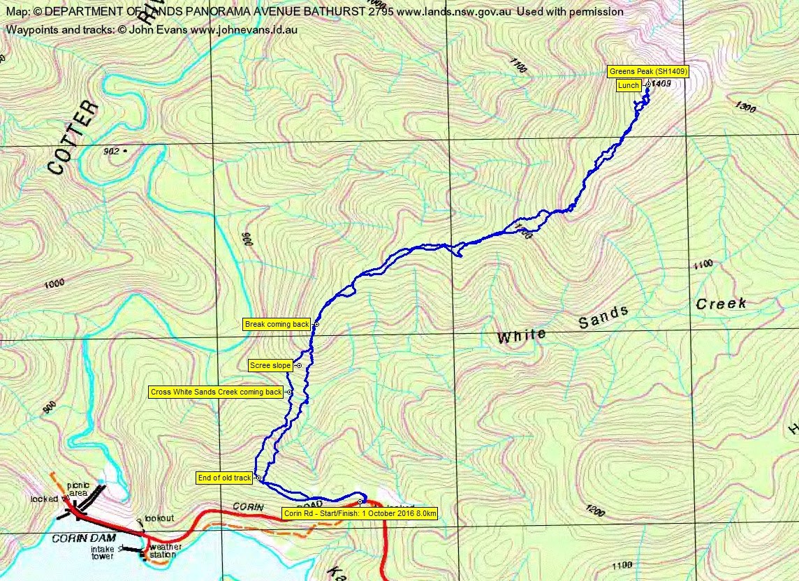
Google Earth snip Greens Peak – SH1409
Saturday 1 October: Peak 1409 – M/R. A challenging walk cross country and through scrub to the lovely shale peak in between Tidbinbilla and the Brindabellas. Participants should not object to scrub. More details will be available from the leader for interested participants. Around 12km and 600m climb. Map: Corin Dam. Leader: David D. Transport: $30 per car. Book by Thursday 29 September.
4 of us met.
Further Information
With the author’s permission, I quote from the fabulous book Rugged Beyond Imagination, Matthew Higgins, National Museum of Australia Press, 2009:
Names have been lost – names that told of events and experiences from years ago. One name not on any maps is Greens Peak, a rocky pyramid jutting beyond Tidbinbilla Valley. Modern maps show it only as a dot (with elevation) amid swirling, closely packed contour lines in a particularly steep and impenetrable part of the ACT. Its origins date from around 1900, when George Green lost some cattle, and cattle thieves were suspected. Three years later George was astounded to be told by a bushman that the beasts were on a rock-faced peak out beyond the end of the valley, where the ground drops away into the forested depths of the Cotter valley. George set off with his younger brother William to retrieve the now wild cattle. In what must have been an admirable piece of rough riding over fallen timber and broken rock, the brothers managed to bring the Herefords in from the rugged peak and down into the gentle floor of Tidbinbilla’s cleared, pastoral valley. To locals, the mountain henceforth became known as Greens Peak.
Summary
Distance: 8.0km | Climb: 640m | Time: 8.55am – 4.35pm (7hrs 40mins), including 40 mins of breaks | Grading: M/R; M(11)+
Photographs
Photographs are available, where you can start a large sized slideshow. Not good quality today as I took them with my GPSr. I usually get part of the cover in front of the lens and can’t see what I’m doing without putting my glasses on.
Waypoint and Track Files
Download the .gpx file. (Right click, Save Link As…, Save – if you want to use it.)
To use in Google Earth, do File, Open… and select Gps or All files as the File Type.
Track Notes
A cool, cloudy, showery spring day, with snow forecast above 1500m. The bush was wet and we wore our coats all day. Hands got very cold in the wet conditions.
We stopped at Gibraltar Falls and walked back down Corin Rd a bit to check that there was no one in a car down off the side of the road.
My first edition Topoview 2006 Corin Dam, OZraster NSW Corin Dam digital maps and Google Earth show a track leaving Corin Rd just before the dam and heading a bit in the direction we needed to go. David had seen it on Google Earth too. So we began by walking in the tarred track. Beautiful purple flowering shrubs. The track ended at a reservoir and power shed.
From here it was pea, scree, snow and showers! And probably in that order of quantity.
A scrubby, shrubby descent to White Sands Creek. It was full and fast flowing; a wet boot or two to get across.
Then the relentless climb. A nice area of scree as we headed up from the creek, one of few open patches. The regrowth, predominantly pea, was rampant. There is really nothing more to say as, unfortunately, there was little view. A few patches of snow especially around the top of Greens Peak. A snatch of a view down into the Tidbinbilla Nature Reserve and across to the dishes of the Tidbinbilla Deep Space Tracking Station. No doubt that was the way George and William rode up. T-shirt and coat coming up as there was plenty of energy expended and heat generated, but it was several layers, beanie and dry gloves on at lunch time and they didn’t come off until the final climb out of White Sands Creek on the return leg.
Our leader neglected to call morning tea on the way up, but was kind enough to give us a break on the way back. One wag in the party suggested that Parks and Conservation had planted too much Daviesia on the spur after the 2003 fires.
3hrs 20mins for the 4km up; 3hrs 50mins for the 4km down. 7 hours of walking for the 8km probably says it all – pretty scrubby.
But wait – why were we there? Why had we tried via High Range on 17 Jan 16? SH1409 appears on the list of the ACT’s Percys and we scored 2 points for today’s efforts.
Thanks David and crew. A worthy objective … worthy of one visit only in my lifetime. Great trip!
Track Map

Party
4 walkers – Chris C, David D (leader), Jonathan M, me.
girts ozols
2 October , 2016 8:09 ampretty impressive!
Linda
2 October , 2016 8:17 amThat was some pretty good exploring on a wet day! Did you get a look into upper White Sands Creek and across to the HIgh Range? Any open areas? I was thinking of going there some time.
Johnny Boy
2 October , 2016 10:31 amA few glimpses. I’d say it would be pretty scrubby and full of regrowth. We got to the knoll at 1500m 1.3km to the east of Greens Peak on 17 Jan 16, so have seen the White Sands Creek catchment from both sides. Cheers. john