Saturday 12 July 2014: Long-time Walkabout – L/M. Something for everyone: southern Namadgi views; indigenous and European sites; border markers and blaze trees; up to 12 hours walking; night walking under a full moon to bay at. From the Yankee Hat car park, insert via fire trail and footpad to the south-east Gudgenby saddle, then through some regrowth down to join the Sams Creek Fire Trail. Easy walking down the Naas Creek valley to Lutons crutching shed. Exit over the Naas Creek ford and north along the Old Boboyan Road. 26km and 660m climb – led by Cynthia C. From the fire trail junction near Lutons, the walk can be extended around the Grassy Creek and Bulls Flat Fire Trails. This makes the day 34km and 820m climb. The full walk is extended to include the Grassy Creek Fire Trail to Waterhole Hut and return via Waterhole and Bulls Flat Fire Trails. A day of 40km and 950m. An additional co-leader required if a sub-group wants to do the 34km circuit. Map: Yaouk. Leaders: John Evans – john@johnevans.id.au, 0417 436 877 and Cynthia C. Transport: ∼$15 per person. Further details at www.johnevans.id.au. Emergency contact details must be registered/provided to book. Bookings close 2pm Thursday.
Proposed Legs
Leg 1: Yankee Hat car park to Leave fire trail for Gudgenby Saddle
Fire trails. POI include views to Mt Gudgenby, Frank and Jacks Hut. 4.7km, ∼55mins.
Leg 2: Leave fire trail for Gudgenby Saddle to Top of open space marking start of Gudgenby Saddle footpad
Open woodland. No track or footpad. Cross a feed drainage line to Bogong Creek. 0.6km, ∼15mins. (Total 5.3km, 1hr 10mins)
Leg 3: Top of open space marking start of Gudgenby Saddle footpad to SE Gudgenby Saddle
Footpad through dry sclerophyll woodland and forest. I will lose the way several times. Major climb of the day, ∼260m. 2.5km, ∼1hr 15mins. Morning tea at Gudgenby saddle (15mins). (Total 7.8km, 2hrs 40mins)
Leg 4: SE Gudgenby Saddle to Sams Creek Fire Trail
Descend on side of drainage line from saddle to join Sams Creek FT. Off-track through some regrowth in woodland. 1.1km, ∼25mins. (Total 8.9km, 3hrs 5mins)
Leg 5: Sams Creek FT to junction with Maurice Luton FT
Initially off-track, then a footpad gradually appears. A couple of damp drainage lines to cross. POI views to granite stacks on the NE ridge.1.7km, ∼30mins. (Total 10.6km, 3hrs 35mins)
Leg 6: Maurice Luton and Sams Creek FTs junction to Lutons Crutching Shed
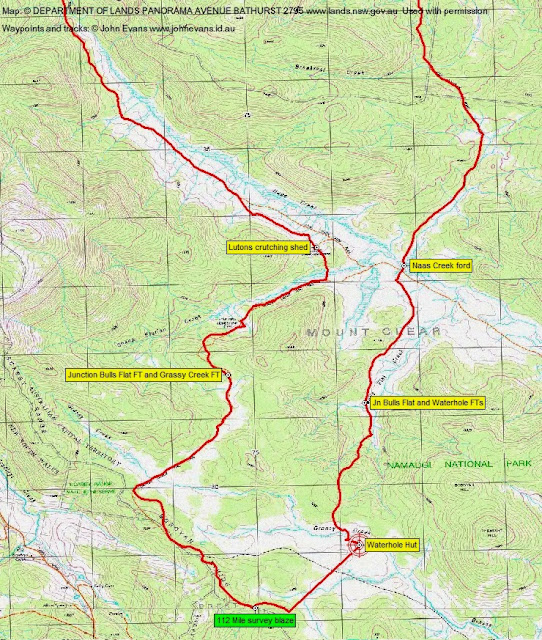
Easy walking on a soft, dis-used fire trail. Once out of the tree line, views down the open valley and back behind to Mt Gudgenby. Possibly views to Sentry Box. Will be cold as exposed to the wind. POI swampy Naas Creek, old fence lines, several hut sites, the crutching shed with its drop log fencing. Lovely country. 4.8km, ∼1hr 15mins. Lunch at Lutons Crutching Shed (30mins). (Total 15.4km, 5hrs 20mins)
Leg 7: Lutons Crutching Shed to cross Naas Creek Ford
Well defined management trails (new gravel causeways over Sheep Station Creek and the next low lying area) passing through the junction of Sams Creek FT and Grassy Creek FT (here the party will split) and then (possibly) the junction of Sams Creek FT and Bulls Flat FT) and then turn north at the junction of Sams Creek FT and the Old Boboyan Rd. A quick 5 or 6 steps across the ankle deep ford of Naas Creek to keep your feet dry. 1.4km, ∼20mins. (Total 16.8km, 5hrs 40mins.
Leg 8: Naas Creek ford to Yankee Hat car park
Well used management road. Hard surface, undulating, but it’s the home run. A few steps across Breakfast Creek, less than ankle deep. 9.2km, ∼3hrs. (Total 26km, 8hrs 40mins)
Longer Options
Those wanting to cover 40km will go south-west along the Grassy Creek FT at the junction of Sams Creek FT and Grassy Creek FT, turn south-east along the new Grassy Creek FT and, either at the junction with the old GCFT or at a convenient spot, head for Waterhole Hut. From there, north on Waterhole FT to join Bulls Flat FT and so to the Naas Creek ford and home.
Because of the extra distance and the fact that we don’t want to walk all night, the entire party will need to cover legs 1-6 as quickly as we can.
Maps
26km

34km

40km
Other Considerations
Sun times are 0643-0711-1707-1735. So ∼10hrs of sunlight.
Leave town at 0700. Start walking at 0800. Say, average 3km/hr, including breaks. 40km in ∼13hrs. That’s 0800-2115.
Moon times are 1705-0622. So should have moon from sunset to finish.
Geocaching
Look for geocaches GC1GP4K A Very Naas Shed, GC4X0H8 Kids at home(stead) 2, WP5 and final GZ for GC2JX02 Wander back in time.
Gear
Wear warm clothes – it was cold down that way last Saturday and Sunday. Gloves, beanie, many layers. Bring raincoat (outer shell) as well as all your usual gear. Gaiters. Include a thermos of hot drink with your food.
40km walkers – we’ll have a quick tea, maybe at Waterhole Hut. Bring a stove if you like. Don’t forget a strong head torch.
Emergency gear – I carry a communications device/PLB. Will bring survival bag or tarptent.