
Fifth views, into confluence of Bundanoon Creek and Tallowa Gully
Tuesday 9 July: Tallowa Gully Clifftop Walk, Morton National Park – L/R, ptX. The start is in the Wingello State Forest 16 km east of Marulan. We’ll walk 6 km east on fire-trails in Morton National Park, then spend about 5 hours off-track following the clifftop on the rim of Tallowa Gully, to a point overlooking Bundanoon Creek. There are excellent views and some interesting side creeks that have carved deep gullies. Some of the walk is in steep, scrubby country and some rock scrambling is likely, when negotiating the small side creeks. Note: this walk continues further east along the clifftops from the point reached on the trip of 11th June. Off-Track: 6 km Fire Trail: 12 km. Leader: Ian W.
Further Information
Completion of the Tallowa trilogy. Previous recent walks in this area on 11 Jun 19 and 25 Jun 19.
Summary
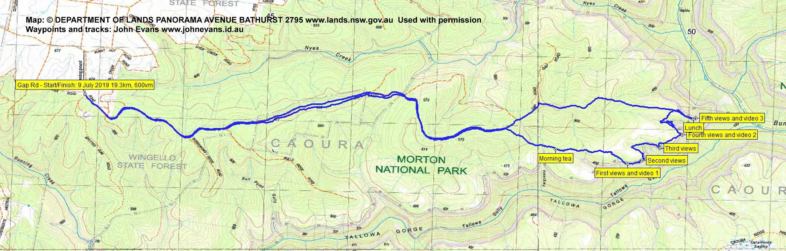
Distance: 19.3km | Climb: 680m | Time: 8.30am – 3.40pm (7hrs 10mins), including 40 mins of breaks | Grading: L/R; HM(13-)
Photographs
Photographs are available, where you can start a large sized slideshow.
Videos
Waypoint and Track Files
Download the gpx file for this trip (if your browser does not automatically download the file, it will open the gpx file in a new window and you can then save it). To use in Google Earth, do File, Open… and select Gps or All files as the File Type.
Track Notes
Met 6.30am in Woden and drove via Hume Highway, Murrimba Rd to Wingello, Forest Rd, Caoura Rd aand through the Wingello State Forest to the corner of Gap Rd and Spotted Gum Rd. Around 2hrs 20mins.
Set off along Gap Rd (a fire trail).

Walking in Gap Rd
After 6km in 1hr 15mins we went off-track through lovely Turpentine forest.

Descending from Gap Rd through Turpentine Forest
We crossed Fergusons Gully, shallow here (but grander as it dropped over the edge when we crossed it on 11 Jun 19) and stopped for morning tea at 10.10am. Plenty of colour in the bush.

Colour in the bush
Continuing generally to the east across another couple of shallow gullies, we reached the top of the cliffs overlooking Tallowa Gully at 11.05am.

Our first look into Tallowa Gully
The plan was to continue along the cliff tops, ducking to the edge whenever possible.
Some wattles out.

Colour in the bush
The views continued to be spectacular.

Second views into Tallowa Gully
More side gullies, getting a little more serious, to be crossed before we reached the third lookout.

Mitchell, Ian and Greg at the third views into Tallowa Gully

Third views into Tallowa Gully
Inland a little to cross this side gully between third and fourth views.

A deep side gully to cross
Our fourth viewing point at last revealed some water in Tallowa Gully.

Fourth views into Tallowa Gully
Between us and the trip’s objective lay the best side gully of the day. An easy ramp got us down to the bottom, which included a nice cave.

A cave in the deep side gully
However, the gully turned into a mini canyon and our way was blocked.

The deep side gully turned into a mini canyon
We extracted ourselves and went a long way inland to get across. The flowering shrubs continued to provide colour.

Colour in the bush
A tongue of the cliffs led us to our objective, a vantage point above the confluence of Bundanoon Creek and Tallowa Gully.
Fifth views, into confluence of Bundanoon Creek and Tallowa Gully
The water level seemed low (friends have paddled up into Bundanoon Creek), but we could see the upstream end of Lake Yarrunga.

Fifth views into Tallowa Gully
A magnificent spot for lunch!

Bundanoon Creek joins Tallowa Gully
At last it was time to leave. We began the walk out at 1.15pm, with last views the the rugged cliffs across Bundanoon Creek.

Cliffs on the other side of Bundanoon Creek
It was a 2km in 55min walk up to join Gap Rd, then 6.8km in 1hr 30mins back to the car.
Another classic trip put on by Ian W. Huge thanks. Great, quick crew.
Track Maps
Track overview
Track 1

Track 2
Party
4 walkers – Greg B, Ian W (leader), Mitchell Z, me.