View from the slab to Mt Gudgenby and Mt Mouat (The Fortress) on the SE Scabby Range
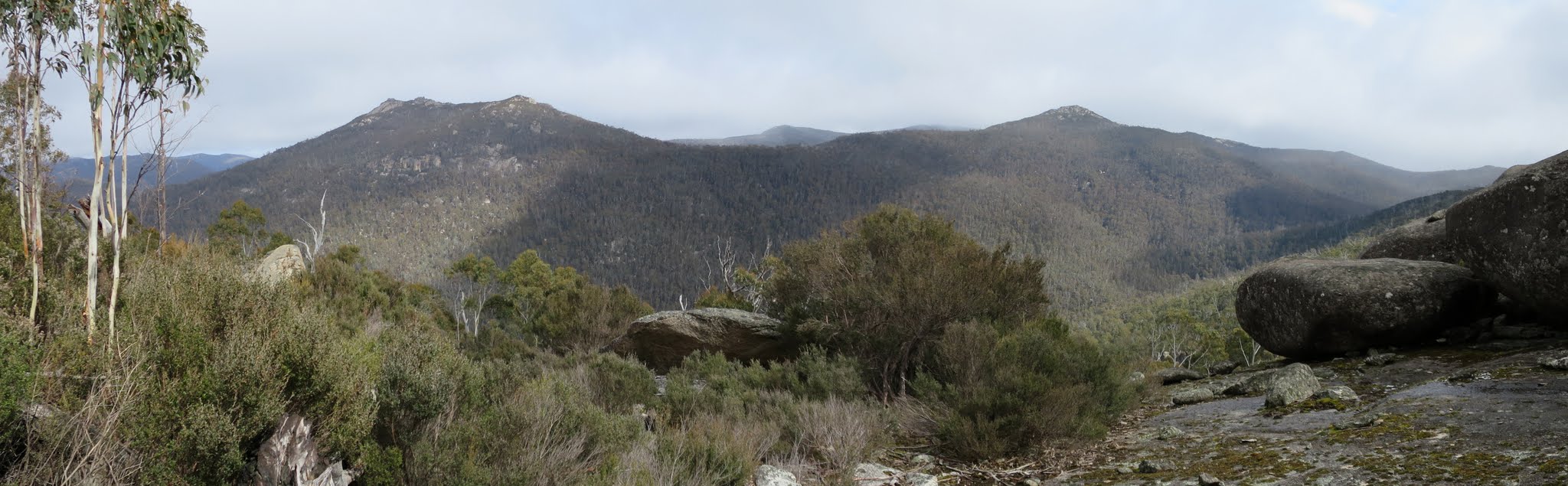
View from the slab with marble along the Yankee Hat ridge including Mt Burbidge and the Mavis Ridge
Tuesday 8 September: Yankee Hat Slabs and Middle Creek, Namadgi National Park – L/R/partX. Starting from the Yankee Hat carpark we will ascend to the crest of the Yankee Hat ridge via the creek and saddle between the two peaks. There are excellent granite tors and extensive views near grid ref. 746418. We will then descend to Middle Creek via a route that links up a number of large tors on the northern flank of Yankee Hat. This is a difficult, off-track walk. There is thick scrub for much of the day and steep rocky slopes to negotiate. Minimum distance: 14 km with ∼600 metres of ascent. Maps: Rendezvous Creek, Yaouk. Leader: Ian W. Transport: 110 km return. Limit: 8.
5 of us drove in 2 vehicles to the Yankee Hat car park.
Summary
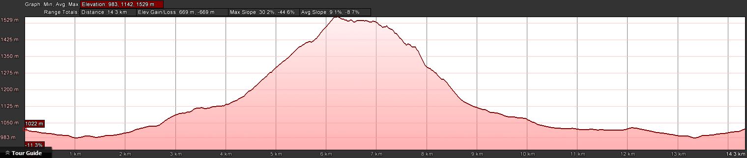
Distance: 14.7km | Climb: 670m | Time: 8.15am-4.10pm (7hrs 55mins), including 55 mins of breaks | Grading: L/R,ptX; H(12+)
Photographs
Photographs are available, where you can start a large sized slideshow.
Videos
Waypoint and Track Files
Download the .gpx file. (Right click, Save Link As…, Save – if you want to use it.)
Download the .kml file.
Track Notes
Hats off yet again to the incredible Ian, the granite hunter, W. This was a fantastic trip. On the way to our first destination, he said that the cavern + Slab with views and the Temple of Doom were the two best lots of granite he’d discovered. That was until we came to Granite heaven, which included major features Slab with marble, Granite wall, and Cracker Jack Tor, on Ian’s unknown to him eXploratory exit route. An incredible area of granite dripping down the hill!
An uneventful insert to morning tea. We wandered in along the Yankee Hat Walking Track to near the rock art, then struck off across to the fire trail corner. Along the fire trail for a bit, then up into the bush to curve round above the drainage line which runs down from the saddle between the two Yankee Hats. Ian kept us reasonably high. The going was moderate scrub, with a few thick patches around the 1170m contour. Morning tea was taken because we were hungry.
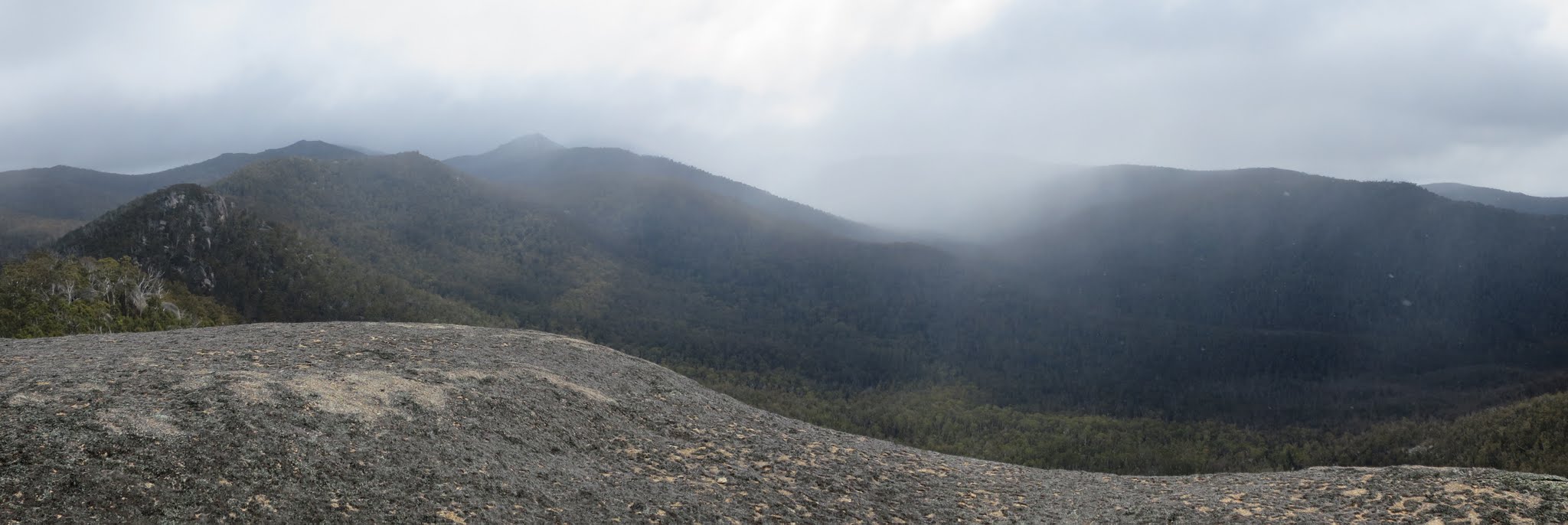
We next sidled across the saddle to a nose north of Yankee Hat South, then continued to climb onto the Yankee Hat ridge which runs out NW from Yankee Hat South. A few teeny weeny patches of snow. A variety of going – thick pea regrowth in places and a rare open patch. 50m east of Ian’s first objective we struck a very dense guardian patch of sappling regrowth. We swam through it – some with a confident breast-stroke style, me dog paddling. After a false lead, we entered the east side of a huge cavern! Lovely! Rivulets of water were frozen into icicles on one side. To the west we exited onto a huge granite slab commanding breathtaking views across to Mt Gudgenby and on up the SE Scabby Range, including to Mt Mouat. We spent some time drinking in the view. It took me a fraction to orientate myself and understand that we were on the SW side of the crest of the Yankee Hat Ridge, looking over Bogong Creek. Views up along the YHR were a bit around the corner.
Next we sidled along the slab to Sundeck slab, an extension of the main one, but with boulders which formed a fine chair. Ian’s planned route was eXploratory from here on.
The going from here to lunch just off the Slab with marble was very slow. First came a dense belt of Common Shaggy Pea (Oxylobium ellipticum) with its hard flower heads, then a patch (small, thank goodness) of pick-up-sticks. But we came in behind the Slab with marble to huge views up along the Yankee Hat Ridge, across to Mt Burbidge and over to the Mavis Ridge. Some snow? showers, so we retreated out of the wind down to a sheltered lunch spot. Time for a tweet and to call home.
Ian’s exit from lunch was eXploratory. It revealed granite that amazed us all! Let’s call the area Granite heaven. We encountered tors and slabs and boulders that positively dripped down the side of the ridge. And they were all the more enjoyable as we were going down, giving us the breath to fully appreciate them. Check out the photos! One peeled-off slab looked like an orc’s sword from Lord of the Rings. Outstanding were the Granite wall and, fully deserving a name from the entire party, ‘Cracker Jack Tor’ (so named because Ian had seen giant cracks on the downhill face on Google Earth). A monstrous tor as we approached and it needed a circle around to get to the base of it. A tree which looked a decent size when viewed from the top, was a huge specimen when we arrived at its butt. A couple of leaf-greased slides to get down to the bottom and, of course, the crack was amazing. Truly a remarkable area and one which I’d viewed with apprehension when descending from the Yankee Hat Ridge further to the north-west.
The last major feature was Granite with overhang, a small cave at its base.
A stop for arvo tea as the descent began to level.
At last we were out onto more pleasant going at a less than vertical gradient. The last leg was quick, crossing the fence line that runs across the two arms of Middle Creek. Said creek gurgled away as we paralleled it to pick up the old vehicle track near the Middle Creek shelter and so back to the cars across the Gudgenby grasslands.
A memorable trip to wonderful features with a great leader and tightly cohesive party. Although it’s always nice to walk with different people, there’s nothing like a small group of evenly matched walkers on whom you can rely to keep the pace.
I’m moving house, so this could well be the last walk I do for the next few months. Please come back every week or so to see what’s happening! I’ll do the Floriade 8am walks and the long long walkabout on 3-4 October if I get a third starter. But the quickest way for me to get back to walking is to sell my current house!
Timings
| From | To | Distance | Time |
| Start | Morning tea | 5.0km | 1hr 40mins |
| Morning tea | Cavern | 1.4km | 1hr 10mins |
| Cavern | Lunch | 0.6km | 50mins |
| Lunch | Cracker Jack Tor | 0.7km | 50mins |
| Cracker Jack Tor | Arvo tea | 1.0km | 50mins |
| Arvo tea | Finish | 6.0km | 1hr 35mins |
Track Map
Track

Profile
Party
5 walkers – Linda G, Meredith H, Ian H, Ian W (leader), me.
Next Tuesday Walk
Tuesday 15 September: Black Andrew Nature Reserve – L/R/X. The Reserve is located 12 km northwest of Wee Jasper. This is a new area for the leader. The walk starts on Grahams Road and is mainly off-track. This is a long exploratory walk, in native forests and woodlands, with numerous steep ascents and descents. There is a 1 hour 40 minute drive each way. Minimum distance: 18 km with approx. 900 metres of ascent. Map: Wee Jasper. Leader: Ian W. Transport: 214 km return. Limit: 8.