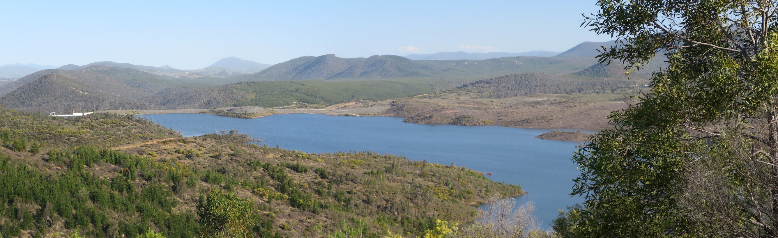
Cotter Dam from geocache GC6Q1WZ Back of the Cotter scenic trail #12
Tuesday 6 September: Back of Cotter caching ride and walk – L/M. Some caches put together by Roger.
2 of us met.
Summary
Distance: 24.5km | Climb: 720m | Time: 10.45am – 4.25pm (5hrs 40mins), including 15 mins of breaks and some driving between parks | Grading: L/M; H(12) ride/walk
Photographs
Photographs are available, where you can start a large sized slideshow.
Video
Waypoint and Track Files
Download the .gpx file. (Right click, Save Link As…, Save – if you want to use it.)
To use in Google Earth, do File, Open… and select Gps or All files as the File Type.
Track Notes
A late start, after I finished work. We drove via the Cotter and Brindabella Rd to turn down Bullock Paddock Rd. 4 rides/walks/geocachings. A beaut early spring day with 20ºC forecast in town.
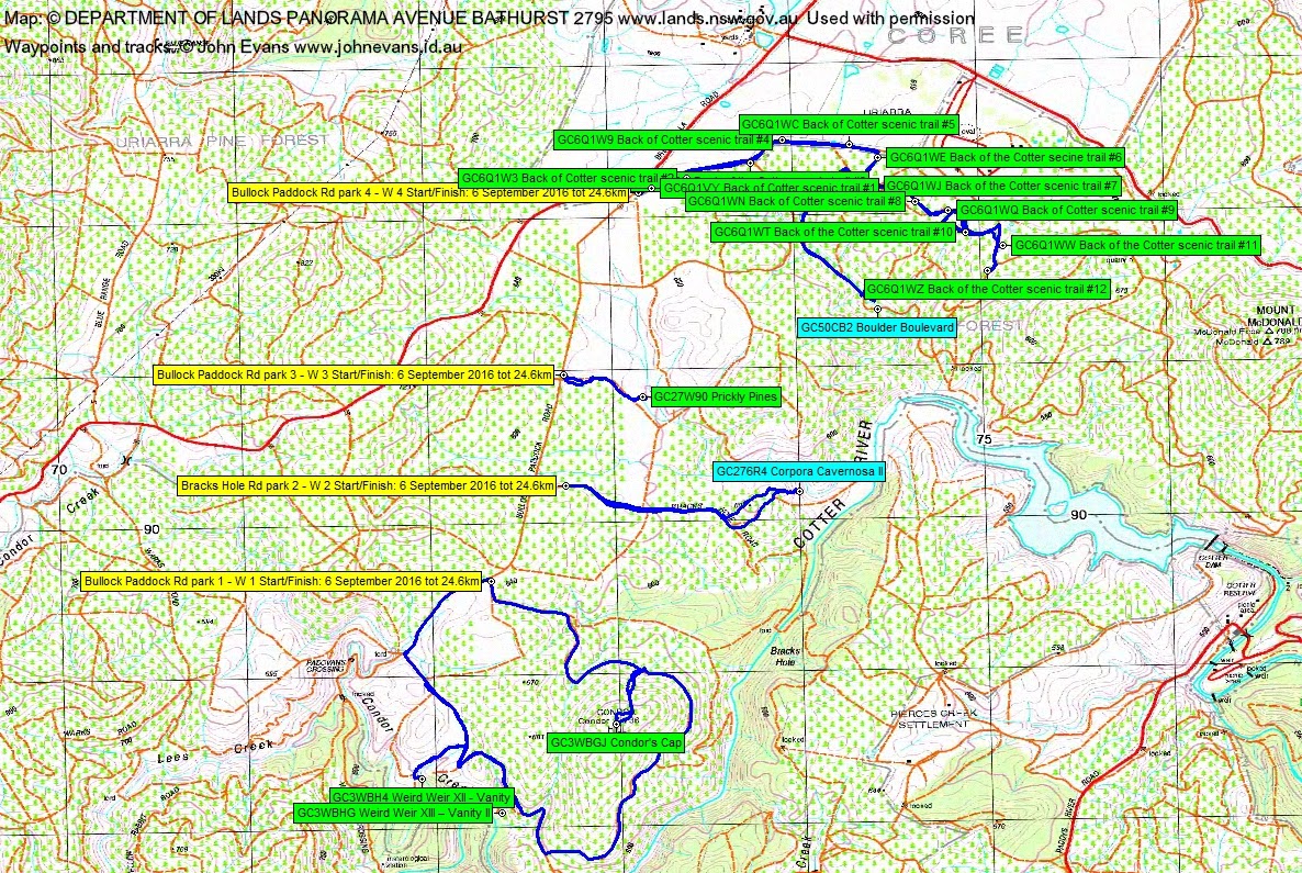
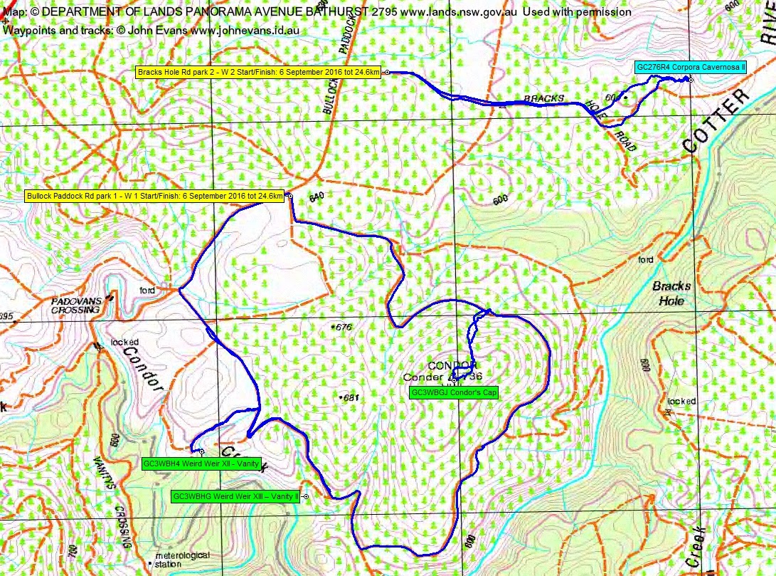
Ride/walk/cache 1
From a suitable spot about 1km NE of Padovans Crossing, we pedalled down a fire trail towards Condor Hill. To its north I spotted a sign which said Spalding Trail, so we thought this would give us good access up the hill. On closer examination the sign read Seedling Trial 😳 . A clamber up through the blackberries to find and log GC3WBGJ Condor’s Cap. Lovely views over the full Cotter Dam. A while since I’ve visited Condor trig. Heaps of hardenbergia in purple bloom.
The plan was to continue clockwise round the hill. South-west of the hill I was riding along TIB-MIN and thought it was a while since I last saw Roger. So I turned around and cycled back a kilometre or so to meet him. My name is in the log book of GC3WBHG Weird Weir XIII – Vanity II, but I have no photo of it today. This cache is at Forestry Compartment 99 (Cpt 99) weir and you can read all about the Brindabella Weirs.
Suitably chastised, I rode meekly behind Roger and we dropped the bikes near the next cache. An old, now moguled, fire trail took us via paddocks of blackberries to Forestry Compartment 97 (Cpt 97) weir. Some geological deconstruction (and later reconstruction) eventually revealed GC3WBH4 Weird Weir XII – Vanity. Again, read all about the Brindabella Weirs.
We rode on back to the car. This ride/walk/cache was 10.6km and took 2hrs 10mins.
Ride/walk/cache 2
After driving back a bit, we turned in and parked at the locked gate on Bracks Hole Rd. It was after 1pm, so lunch was taken. We rode in, then walked to find GC276R4 Corpora Cavernosa II. A bit of a surprise and a lovely view at the location – the cache is now well underwater. It pays to read the cache description prior to hopes rising. It says “Located near the Cotter Dam this site may go underwater in about 2 years time once the dam wall has been built and the waters rise.” So don’t try this one if Cotter Dam is full! More blackberries.
Rode back to the car. This ride/walk/cache was 3.2km and took 40mins.
Walk/cache 3
Further north back along Bullock Paddock Rd we stopped west of the next cache. A fire trail along the edge of the pine forest area showing on my 2006 maps is now moguled and not able to be ridden, so we walked in through water lying everywhere and – you guessed it – blackberries. A lovely location for GC27W90 Prickly Pines in a stand of tall, unburnt pines.
Walked out. This walk/cache was 1.2km and took 20mins.
Ride/walk/cache 4
Back just near the junction of Bullock Paddock Rd and Brindabella Rd we parked, pulled the bikes off the bike rack again and set out for the Back of Cotter scenic trail series of geocaches. All were logged. We found GC6Q1VY Back of Cotter scenic trail #1, GC6Q1W3 Back of Cotter scenic trail #2, GC6Q1W5 Back of the Cotter scenic trail #3, GC6Q1W9 Back of Cotter scenic trail #4, GC6Q1WC Back of Cotter scenic trail #5, GC6Q1WE Back of the Cotter secine trail #6 and GC6Q1WJ Back of the Cotter scenic trail #7.
At this point Roger had another cache that I didn’t. But each with a Garmin Oregon 650 GPSr, we were able to send the cache wirelessly from Roger’s to mine. So off we headed after it, down fire trails to the edge of the Dam. We crossed a running creek and forged through more blackberries, but this cache was also underwater. All was made clear later – Roger had downloaded GC50CB2 Boulder Boulevard prior to it being archived … because it’s underwater!
Probably more walking + bike pushing than riding as we returned up the hill.
Back on high ground, we found GC6Q1WN Back of Cotter scenic trail #8, GC6Q1WQ Back of Cotter scenic trail #9, GC6Q1WW Back of the Cotter scenic trail #11 and GC6Q1WZ Back of the Cotter scenic trail #12 with its grand views. At last a downhill ride. Stopped and did GC6Q1WT Back of the Cotter scenic trail #10 on the return.
We were wacked by the time we got back to the car. This ride/walk/cache was 9.7km and took 1hr 50mins.
Hard day, thanks Roger.
Track Maps

Party
2 riders/walkers – Roger E (leader), me.