
Navigation Exercise
Saturday morning 6 January 2024: Callum Brae Map and Compass Navigation * – S/M,ptX. Come and help me set up a map and compass training exercise for CBC new/emerging leaders, and any members who want to try their navigation. Stroll around Callum Brae Nature Reserve setting up waypoints and bearings. Bring your compass and morning tea. Only 6km and 100vm.
Summary
From Garmin Connect (MAP66i) – Distance: 6.65km | Climb: 180vm (Elev Corrections Disabled) | Time: 1:47 moving + 2:31 of stops = 4:18 | Grading: S/M,ptX; E(7).
Photographs
View photographs here.
gpx file
None – that would give the exercise away.
Track Map
Here’s where we went (on 8727-3N Second Edition Canberra 1:25000 topographic map © 2003.

Track Callum Brae Map and Compass Navigation
Trip Report
We met at the entrance to Callum Brae Nature Reserve at the civilised hour of 9am. The idea was to check it out via whoever booked on the walk. So glad I did! Several errors discovered, now fixed.
It’s possible to do this map and compass navigation exercise in a self-guided fashion, but the consensus was that it would be better with and on the ground facilitator.
It’s not an introduction to map and compass work, so you’ll need to know your way around 1:25000 topographic maps and how to use a baseplate compass.
If you don’t have a map of the area, you can download and print the relevant segment by following these instructions:
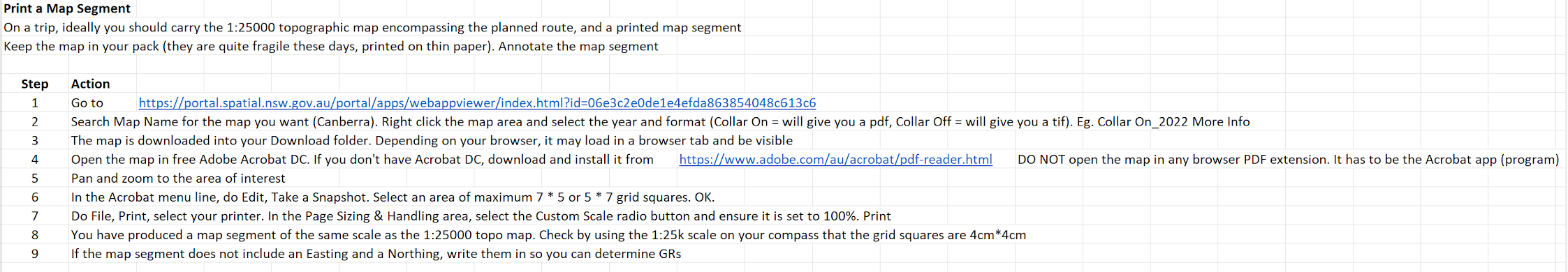
Obtain the relevant map segment
However, whether on the latest commercial map edition or the segment obtained above, there is not much detail of the Callum Brae Nature Reserve area. Here’s an image of the map segment snipped from Collar On_2022, hence © 2022.

Navigation Training Callum Brae Nature Reserve map segment
Our first task was to determine the Grid Reference of the entrance, which is not shown on the map.
The second task, given the GR of the end waypoint for the first leg (or bound), was to use our flatbed compass to determine the grid bearing to the Big butt tree and the straight line distance, then calculate the magnetic bearing.
We soon got the hang of the compass being a dual tool.
- when working on the map and with grid bearings, ignore the magnetic needle, but be very aware of lining up the side of the flatbed from start location to destination with the Direction of Travel arrow pointing to the destination, and carefully lining up the Orienting lines with the Eastings on the map with the Orienting arrow pointing Grid North
- when using the compass to navigate to a destination, hold it horizontally (level) in front of you with the Direction of travel arrow pointing towards your destination. Ensure the red Magnetic needle is exactly over the red Orienting arrow (Caro Ryan’s “put red Ned in the shed”). Choose an intermediate, recognisable object along the line of travel and make your way to it via the best possible going (ignoring the compass). Repeat these intermediate steps till at the destination waypoint for the bound.
It reads a mouthful, but makes sense and is easy after multiple applications.
We got to the end of the first bound.

Big butt tree waypoint
The second bound involved identifying the destination on the map (building, small icon – see a real map legend), and bearing and distance measurements. Mugga Lane acted as a catching feature – if we hit it, we’d gone too far.

Northern Explosives Store destination
Party members had not visited the powder magazines before, so it was worth going further to the signage outside the southern building.

Signage at southern Explosives Store
The third bound was to the Symonston Pumping Station. I thought I’d shot myself in the foot with the route card, but Sandra kindly pointed out that the destination GR was given at the start point for leg 4.
We enjoyed morning tea on the grass near the pumping station.
We were a bit short of the ‘Crest of spur’ destination for bound 4.
Here are two of the participants hard at work.

Navigators hard at work
A handy fence marking the boundary of the NR and the Quarry provided a handrail for bound 5’s destination. The final approach was a but scrubby and scratchy. I thought we might get a view of the quarry but no.
I was caught out in my preparation of the next leg. If you have a look at the track map, there are 132vK power line pylons marked on the © 2003 map. I’d originally used one, the waypoint 132kV power pole, as a location. However, on the © 2022 map segment, there are none marked. So the route card now has a location of ‘Power pole at first bend’. Again, the transition lines and the NR boundary fence provided handrails. A salutary lesson – map features change.
Bound 7 took us to a dam, arriving at midday. By consensus, we continued on two more bounds. The next was to a wonderful horizontal tree. Bothe the tree locations had been shown to me by Teresa Z. The final leg that we did was to the gate at the entrance to the Jerrabomberra West Grasslands Nature Reserve.
Interesting techniques.

Husband uses wife as map case to do his calculations
Now 12.35pm, we cut for home.
Thanks everyone. Very useful feedback.
Party
5 walkers – Kerrie F, Stephen and Lisa M, Sandra T, me.
AllTrails
No AllTrails map.
Johnny Boy’s Walkabout Blog FaceBook Page
I’ve started up a FaceBook page. Each trip report posts to it. It’s another way to get some info to get out and breathe a bit of fresh air. Why not pop over and Follow the page, or give a post a Like.