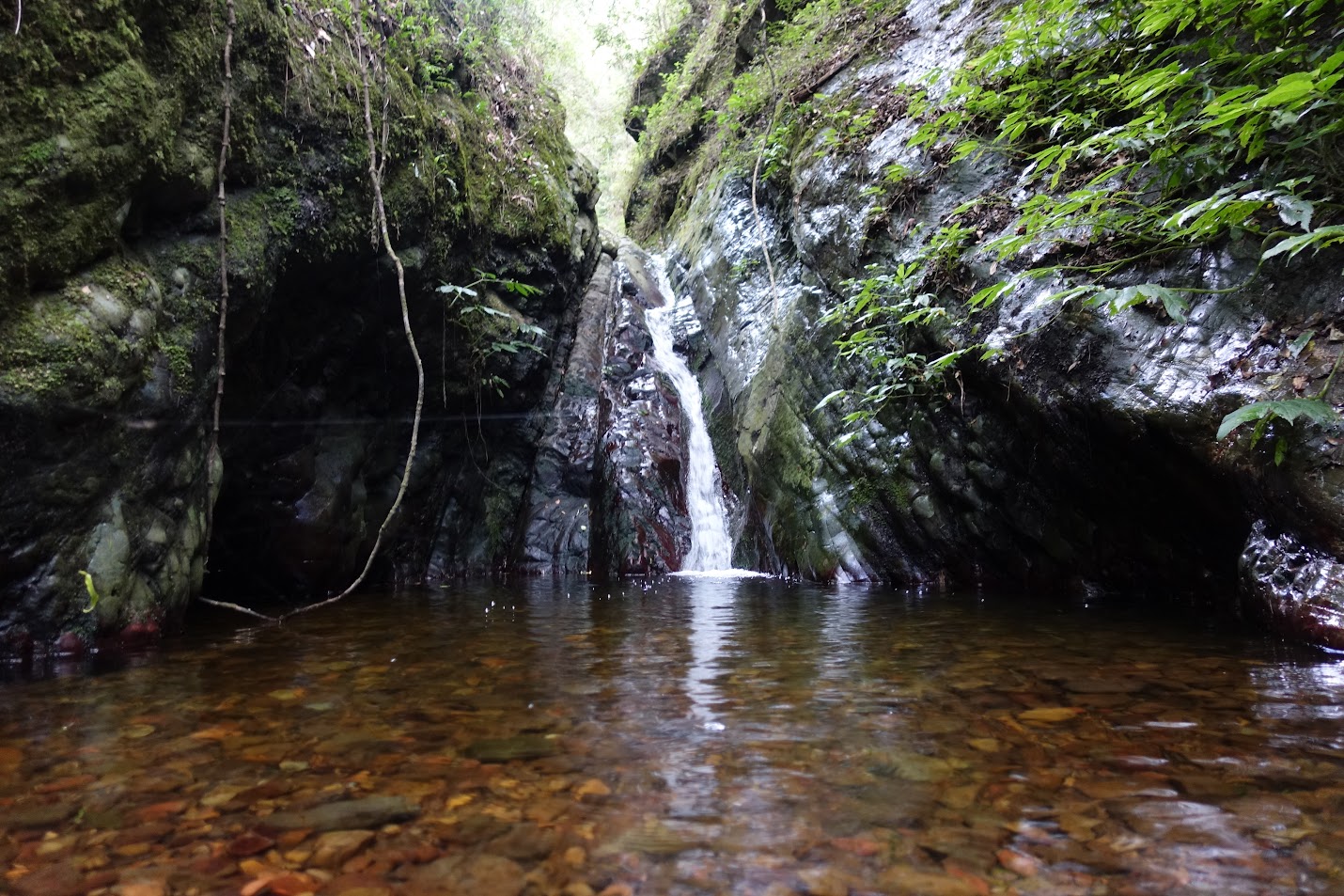
Last waterfall on upper ‘Pooh Corner’ Creek
Tuesday 6 February 2018: Below Pooh Corner – M/R,X. Have you ever gazed at the beautiful forest below Pooh Corner on the Kings Highway? Come see what it’s like. We will leave one car at Pooh Corner and start the walk about a kilometre down the highway where there is a place to park well off the road, then follow a ridge with a moderate gradient down 400 vertical metres to an unnamed tributary of Sugarloaf Creek. Then back up the tributary to Pooh Corner. On Google Earth, it looks like rainforest all the way, and at the top, I hope, Eucryphia forest. I’ll be aiming to avoid any wading or compulsory swims, though there is a slight possibility of them. For walkers with recent experience in rough (‘R’) grade walks. A 1 hr 20 minute drive from Queanbeyan. Leader: Linda G.
Summary
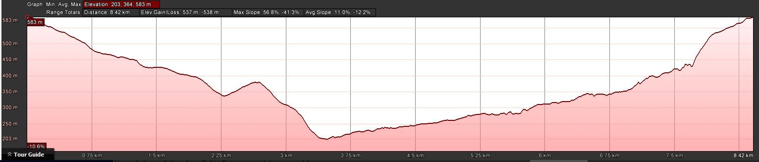
Distance: 8.6km | Climb: 530m | Time: 9.00am – 3.00pm (6hrs), including 60 mins of breaks | Grading: M/R; M(11+)
Photographs
Photographs are available, where you can start a large sized slideshow.
Videos
Waypoint and Track Files
Download the .gpx file. (Right click, Save Link As…, Save – if you want to use it.)
To use in Google Earth, do File, Open… and select Gps or All files as the File Type.
Track Notes
Nice to have a zizz as I was whisked in comfort from Spotlight at Queanbeyan to our parking at the next corner below Pooh Corner on the Hings Highway. It requires a turn across the up-lane of the road, so care is needed. But once off the Highway, you can drive in a few tens of metres. Around 1hr 15mins for the trip.
The walk began not with a bang, but a whimper (although a very pleasant one). The bang came later in the day. An overgrown snig track gave us a relatively clear route down south-east, east and south-east to morning tea. The drop was gently graded and the day and company very pleasant. Morning tea was called at 5 past 10, a little late for Ian (the bear) H.
Munchies finished, we turned south and dropped 200 vertical metres down to Sugarloaf Creek.
After a brief pause by the water, we immediately turned up an unnamed side creek which rises in the very steep bowl below Pooh Corner on the Kings Highway. So I shall dub it ‘Pooh Corner’ Creek. We were again lulled by very pleasant walking. After skirting two little drops, the creek rose ever so gently through rain forest. Ferns and palms were in abundance. The walk up the creek to lunch was 2.5km and took 1hr 20mins.
The creek walking after lunch remained pleasant, perhaps lulling us into a false sense of security. But the sides closing in and becoming more vertical in places and a check of contours showing that we had 400 vertical metres to climb up to the road, indicated that there was some serious climbing to do. Beautiful rain forest vegetation – ferns, palms and magnificent eucalypts.
We climbed around a couple of cascades (one of which was at the bottom of quite a canyon), dropped back down to the creek for a break, then came to the bottom of another waterfall. Here the way on up the creek was barred. Linda took my life in her hands (haha, not funny) as she led us up and around the falls. A tricky narrow ledge was negotiated (the assessment was that if there was a fall, only acres of skin would be lost and a broken ankle and arm suffered, not death). Once again the way was barred, so we began a very steep climb out and up to join our inward track.
Once again, hats off and many thanks to Linda for a trip in awesome country. If you get a chance to do any of her trips, they are always interesting, exciting and often challenging. But she brought us home alive 🙂 .
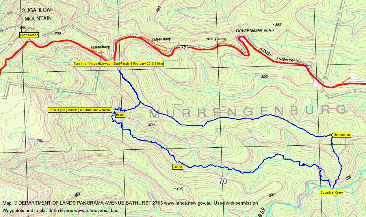
Track Map
Party
8 walkers – Mark B, Peter C, Georgie D, Linda G (leader), Meredith H, Ian H, Ian W, me.