
Descending the pass from Flat Top Mountain
Saturday-Sunday 6-7 May 2023: Budawangs – Flat Top Mountain. A Budawangs walk starting at the end of Meangora Rd, Nerriga, 2h drive each way from Canberra. We follow Alum Fire Trail south for 6km then descend 1km to a campsite near Running Ck. Afternoon side trip of 3km return off track with day packs to Castle Hill. On Sunday return to cars, with a day pack detour of just 1km return to Flat Top Mtn.
Summary
From Garmin Connect (Epix Gen 2)
Total – Distance: 14.18km | Climb: 350m | Time: 1.5 days | Grading: M/M; M(9).
Day 1 – Distance: 9.29km | Climb: 300m | Time: 2:08 moving + 3:55 of stops = 6:03
Day 2 – Distance: 4.89km | Climb: 50m | Time: 1:09 moving + 0:20 of stops = 1:29.
Photographs Photographs are available here.
gpx File The gpx file is available here.
Gear List available here.
The pouches I use to hold and protect my MAP66i and phone attach very nicely to my day pack, but do not to my overnight bag. Thanks to Ian (the granite hunter) W for the suggestion to use cable ties – worked perfectly.
Track Notes
I was in this area 29 Sep – 2 Oct 18 and 26 Jul 11.
Unfortunately things were agin us this trip. The pass was impassable (for us), the scrub nice and thick and the weather forecast doubtful. But we had a good time.
I was whisked in palatial comfort in the Palisade to the end of Meangora Rd, not daring to touch the heated seating controls and personalised cabin comfort. We went via Braidwood, sealed road a bit worse for wear in places, including a few kilometres of dirt being resealed. Meangora Rd is in good nick.
Walking by 9.40am, having met at Spotlight in Queanbeyan at 7.45am.

Crossing the swamp into Morton National Park just near the parked cars
Nice weather so far.

Walking in the Alum Fire Trail
It becomes a bit less bare, with rampant regrowth on either side.

Walking in the Alum Fire Trail
Lots of Banksias.

Budawang Banksias
We stopped for morning tea just after 11am.
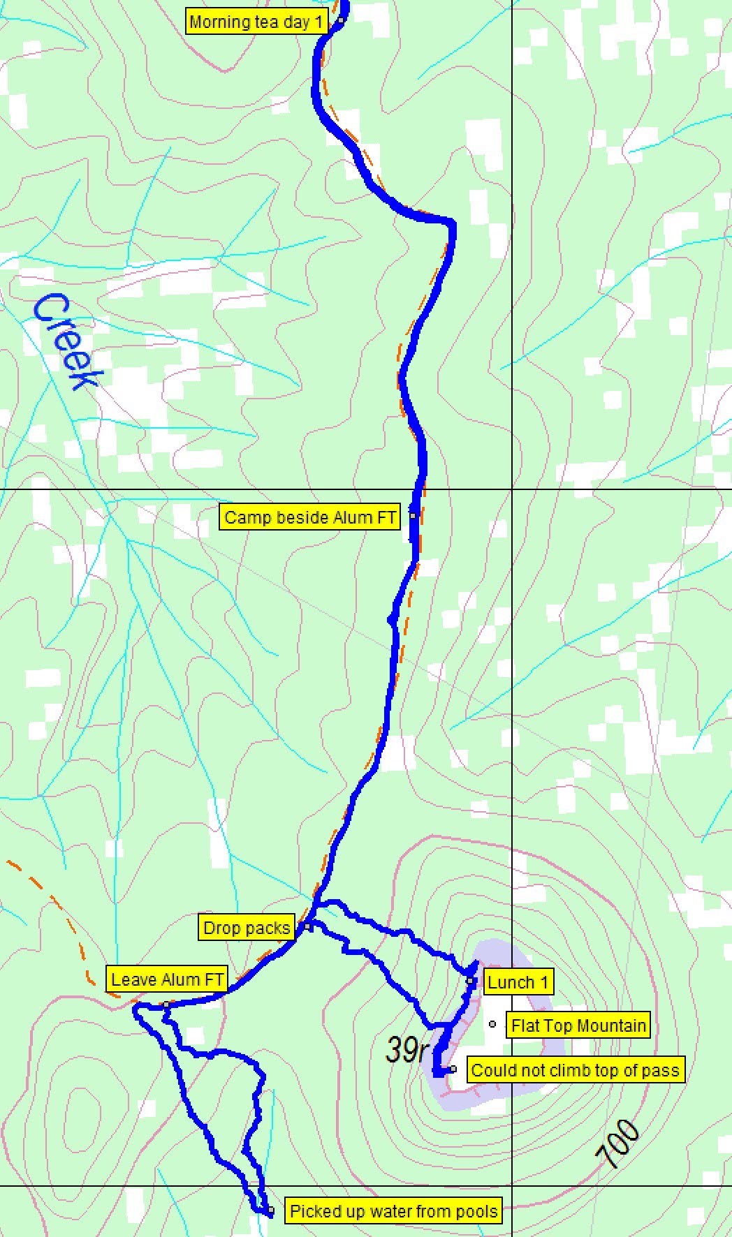
Our leader adjusted plans due to the following day’s weather forecast, so at 11.45am we reached a point on the Alum Fire Trail to turn off to visit Flat Top Mountain. The thick track-side regrowth thinned a little on the short climb to the Flat Top Mountain 39r (relative height) cliffs.

Approaching the Flat Top Mountain cliffs
We arrived at a nice little overhang.

An overhang on the west side of Flat Top Mountain cliffs
We turned south and walked the base of the cliff line until we came to a pass, marked by a couple of rocks making a cairn. So obviously the correct way to reach the top.

View up the main west pass to Flat Top Mountain 39r
Unfortunately, towards the top it beat us. Our leader, Jeff, had been up it some years ago and lamented the passage of years (“passes on Flat Top Mtn once considered easy are not any longer”). We had to come back down.

Descending the pass
Some aerial imagery showed another possible pass to the north, so we checked that out.

Checking out another possible pass from its south side
Further north it was no better.

Checking out the cliffs further to the north
So we had lunch and returned to pick up our packs.
The next planned leg was to descend to find a camp site down near Running Creek. This time the regrowth beside the fire trail did not thin.

Close going after leaving the Alum Fire Trail
Maybe it got even worse.

It didn’t get any easier
We didn’t like the thought of returning up through this, wet by the next morning’s forecast rain. So we found a couple of pools in the drainage line we were following and picked up water for a dry camp.

Water point
Returning to the Alum Fire Trail, our leader remembered a bit of a track-side clearing back in the direction of the cars, so we headed for that. Set up and had a nice fire.

Camp fire
I won’t name the two walkers who, like me, carried in a chair. We played some rounds of ‘what animal is that?’ (thanks for the idea Jan). I was late to bed, hitting the sack at 6.31pm under a beautiful full moon. Messaged my dear wife via the Garmin MAP66i inReach service, to ensure that she’d let me back in the house as it was our 51st wedding anniversary. She informed me that it was raining on Charlie’s parade.
A warm and comfortable night. It started showering around 4.30am, but had the decency to stop as we packed up and walked out.

Walking out the damp Alum Fire Trail
A stop at the Braidwood Bakery for coffee and cake. Colder there than where we were. Wetter on the road home and in Canberra than where we were.
Thanks Jeff and all. Hats off to one in the party. Second CBC trip, first overnighter, new gear, walked and camped like an expert, putting me to shame with their set up and pack up proficiency.
Track Map
Here’s where we went.
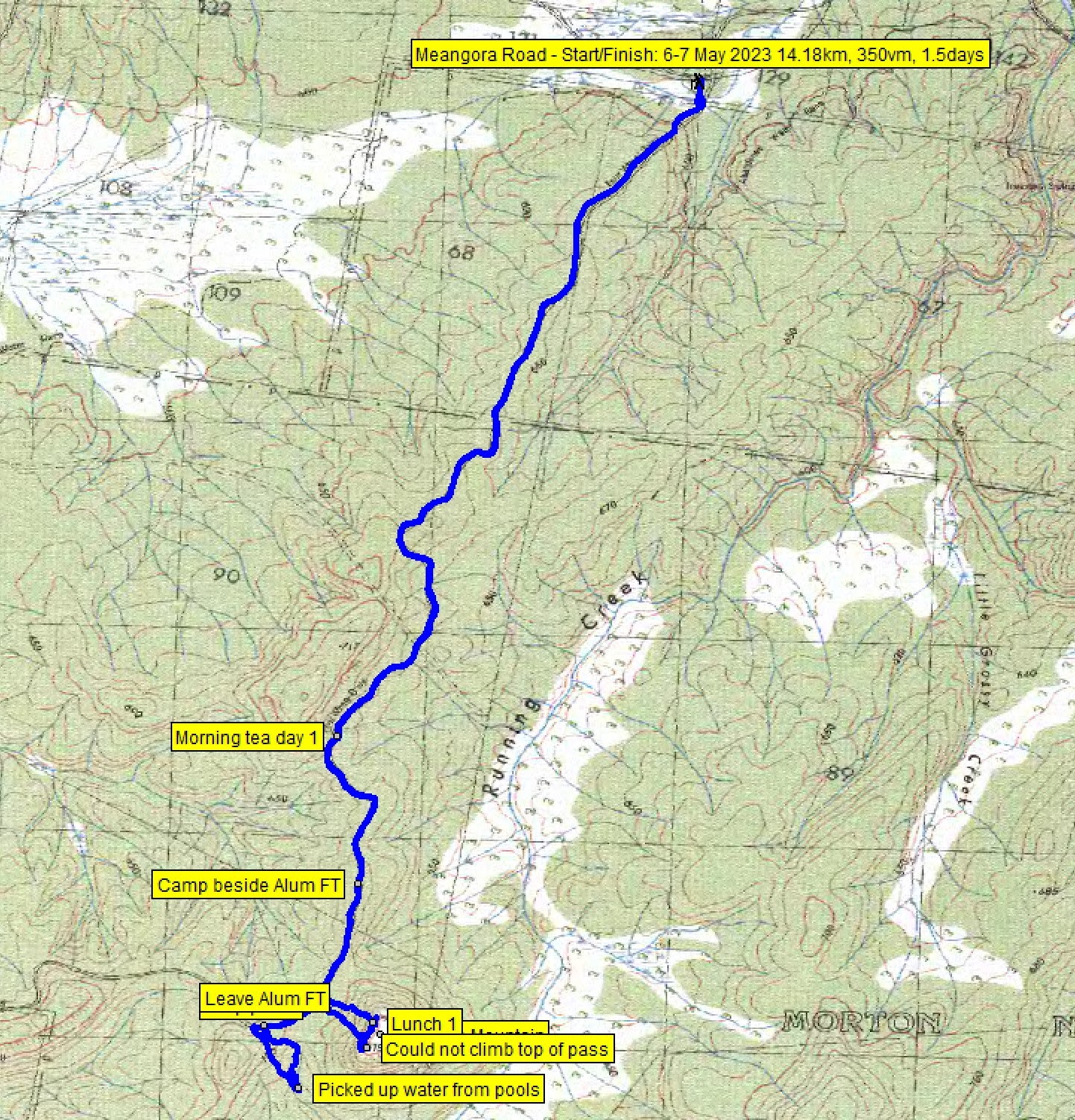
Track overview Budawangs – Flat Top Mountain
Track Budawangs – Flat Top Mountain

Budawangs – Flat Top Mountain detail
The AllTrails map is here, where you can pan and zoom.
Party
7 walkers – Jeff B (leader), Charlie C, Jan H, Tammy L, Craig L, Jingjing P, me.
Johnny Boy’s Walkabout Blog FaceBook Page
I’ve started up a FaceBook page. Each trip report posts to it. So it’s another way to get some info to get out and breathe a bit of fresh air. Why not pop over and Follow the page, or give a post a Like.
Tammy Lee
7 May , 2023 6:21 pmJohn and All, the owl we heard at dusk when we were by the fire was a Powerful Owl. Tammy.
Johnny Boy
7 May , 2023 7:44 pmHi Tammy. You are amazing. Your bird knowledge is pretty good, too. Cheers. john
Beat Oppikofer
7 May , 2023 7:36 pmI was missing BushWalking, yesterday and today, I was booked into this walk, but my work did cancel this walk,
I was working over the weekend at near Potts Point- Bondi Junction, Sydney,
I am looking forward coming home to Canberra in the next few days
Johnny Boy
7 May , 2023 7:47 pmHi Beat. Must be a fantastic kitchen you’ve built and are installing. We’re off on Tuesday to do your caches south and above Fishing Gap. Cheers. john