Autumn colour in the deciduous plantings opposite ‘Sherwood’

Tuesday 5 April: Two Sticks Hill & Mt Dowling – L/M-E. A walk mainly along fire trails to Two Sticks Hill and then Mt Dowling and Sherwood. Start is from Blue Range Hut. This trip is designed for those interested in geocaches. I intend to look for about 12 on the day. About 18km and 500 metres of climbing. Map: Cotter Dam. Leader: Roger E. Transport: Approx $20.00 per car. Limit: 8.
3 of us drove to the Blue Range Hut car park.
Summary
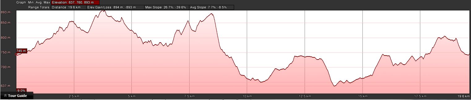
Distance: 21.3km | Climb: 890m | Time: 7.30am-3.20pm (7hrs 50mins), including 45 mins of breaks, caching time and a short drive | Grading: L/E&R; H(13)
Photographs
Photographs are available, where you can start a large sized slideshow.
Waypoint and Track Files
Download the .gpx file. (Right click, Save Link As…, Save – if you want to use it.)
To use in Google Earth, do File, Open… and select Gps or All files as the File Type.
Track Notes
A warm autumn day was forecast, but it didn’t feel like it got to the 29ºC reached in Canberra. Still, we got through the water. Our trip took us along the fire trails of the old Uriarra Pine Forest (mostly replanted since the 2003 fires) and for a while in NSW’s Brindabella National Park, a little off-track and some absolutely horrible blackberries.
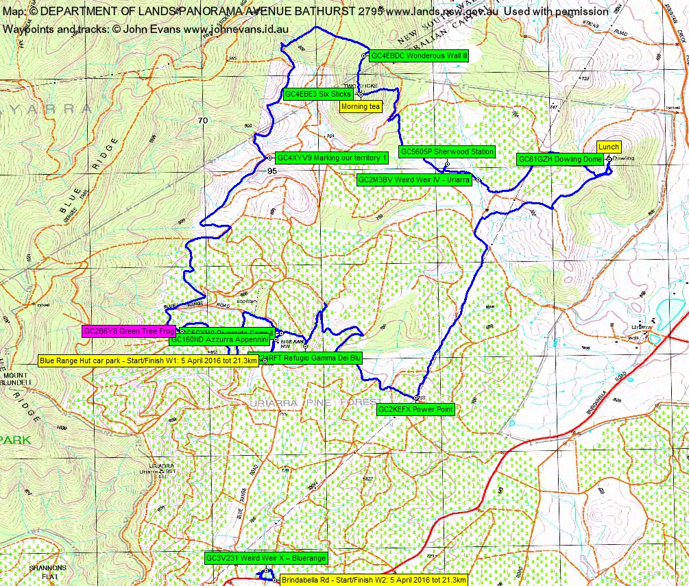
Started by collecting the information for GC160ND Azzurra Appennini. On the way to the final GZ, we slipped into the bush to pick up GC5CXM0 Riverside Camp II. On to pick up the first cache (the published track maps and gpx file have been doctored to not show the final GZs of the 2 multi-caches).
Then west to register a DNF for GC2B6Y8 Green Tree Frog. A long search; most frustrating.
Around 3km north we found GC4XYV9 Marking our territory 1. On the way we passed two machines cutting the blackberries back on the side of a fire trail.
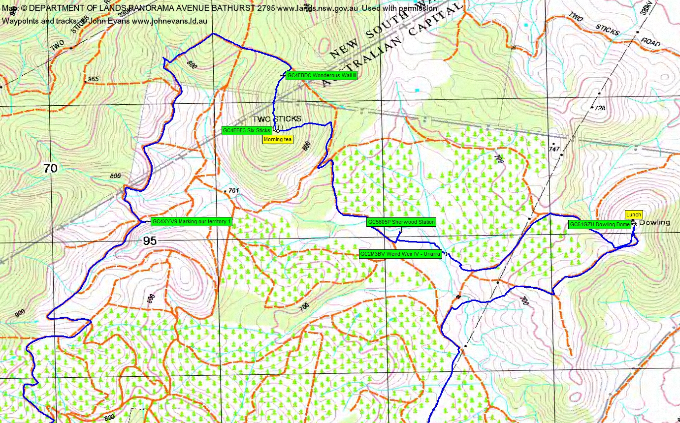
Next a 2km loop north and east via NSW to access Two Sticks Hill from the north. Some degraded fire trails, one a heart-starting 90 vertical metre climb. On Two Sticks Hill we found GC4EBDC Wonderous Wall III, wandered through light scrub south along the hill to the Two Sticks Hill cairn and geocache GC4EBE3 Six Sticks. Morning tea.
We exited from the hill to the east, a 140 vertical metre drop through dense (but thankfully) dry scrub. Picked up the fire trail with the Sherwood markers on it and so down to the ‘Sherwood’ site. Always a lovely spot, passing by the lovely deciduous tree plantings near it. Found the daffodils in flower (aren’t they supposed to be out in spring?) and GC5605P Sherwood Station.
Followed the old trail marker posts to cross the nearby creek and battle a few blackberries at a fence line to get into Uriarra weir. Gathered the clues for the final GZ of GC2M3BV Weird Weir IV – Uriarra and pounded the fire trails to the cache (note again, the track has been doctored so as to not give away the final GZ).
A bit more fire trail then a climb up a dry gully got us to Dowling trig, GC61GZH Dowling Dome and lunch.
Another fire trail down from Mt Dowling. Watching the kangaroos, we were able to follow their tracks through fields of blackberries to cut a corner, then a long haul up the power lines to SH755 and a find of GC2KEFX Power Point.
From here we followed fire trails to within 200m of the next cache. However, it was up a hill and the side of the fire trail was guarded by rampant blackberries, so we took a long detour to approach it from the NNE. Even the last fire trail was a mess of blackberries, so we had to parallel it through the dark pine forest. Found GC24RFT Refugio Gamma Dei Blu.
An exit to the west down a dry hillside had us in the band of eucalypts by the creek beside Blue Range Hut, then back up to the Hut and down the road to the car.
Not quite finished, we drove to the Condor Hut site and a quick find of GC5QAJP Condor Cabin.
Then to a spot we could park on the side of Brindabella Rd and a blackberry scramble in to Blue Range weir. We came in the true left side of the creek line and got to the weir and 15m from the cache. But we could get no further. So a painful retreat and slightly less blackberry insert up the true right side of the creek. Eventually found GC3V231 Weird Weir X – Bluerange, the location ∼8m out according to our GPSrs.
That was it. Thanks Roger for organising and Ian for joining us.
Track Maps
Track overview
Track 1

Track 2
Track 3

Profile
Party
3 walkers – Roger E (leader), Ian W, me.
Next Tuesday Walk
Tuesday 12 April: Blue Gum Creek Granite, Namadgi National Park – M/R/X. From the Honeysuckle Creek campground we head north into the upper catchment of an arm of Blue Gum Creek to visit some granite outcrops and slabs. We will return via the southern flank of Booroomba Rocks. This is a mostly exploratory walk with difficult going in places and thick scrub. Minimum distance: 11 km with 600 metres of ascent. Map: Corin Dam. Leader: Ian W. Transport: 84km return. Limit: 8.
@chifley_alison
5 April , 2016 9:28 pmSuch blackberries! That’s geocaching determination.
Johnny Boy
5 April , 2016 9:57 pmCost Roger his shirt!