
The Castle from Byangee Walls
4-7 August: Byangee Walls and Pigeon House – L/R. A Budawangs stay at Bhundoo Bush Cottages with walks. Leader: Barry K.
Further Information
Byangee Walls have been a bucket list destination for me ever since I saw them from The Castle on 9 Jan 10. And my last visit to Pigeon House was on 16 Jun 01.
Having spotted photos of Barry’s recce a few weeks earlier on Facebook, I wheedled my way onto the walk and into some transport from Canberra.
Summary
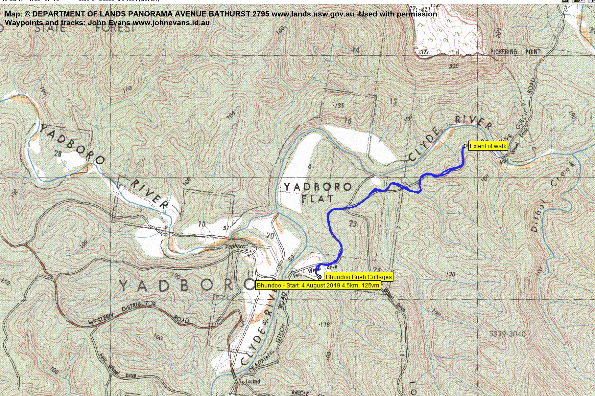
Walk 1 – Distance: 4.5km | Climb: 125m | Time: 3.20pm – 4.40pm (1hr 20mins) | Grading: S/E; E(4)
Walk 2 – Distance: 11.9km | Climb: 1100m | Time: 8.00am – 3.50pm (7hrs 50mins) | Grading: L/R; H(13)
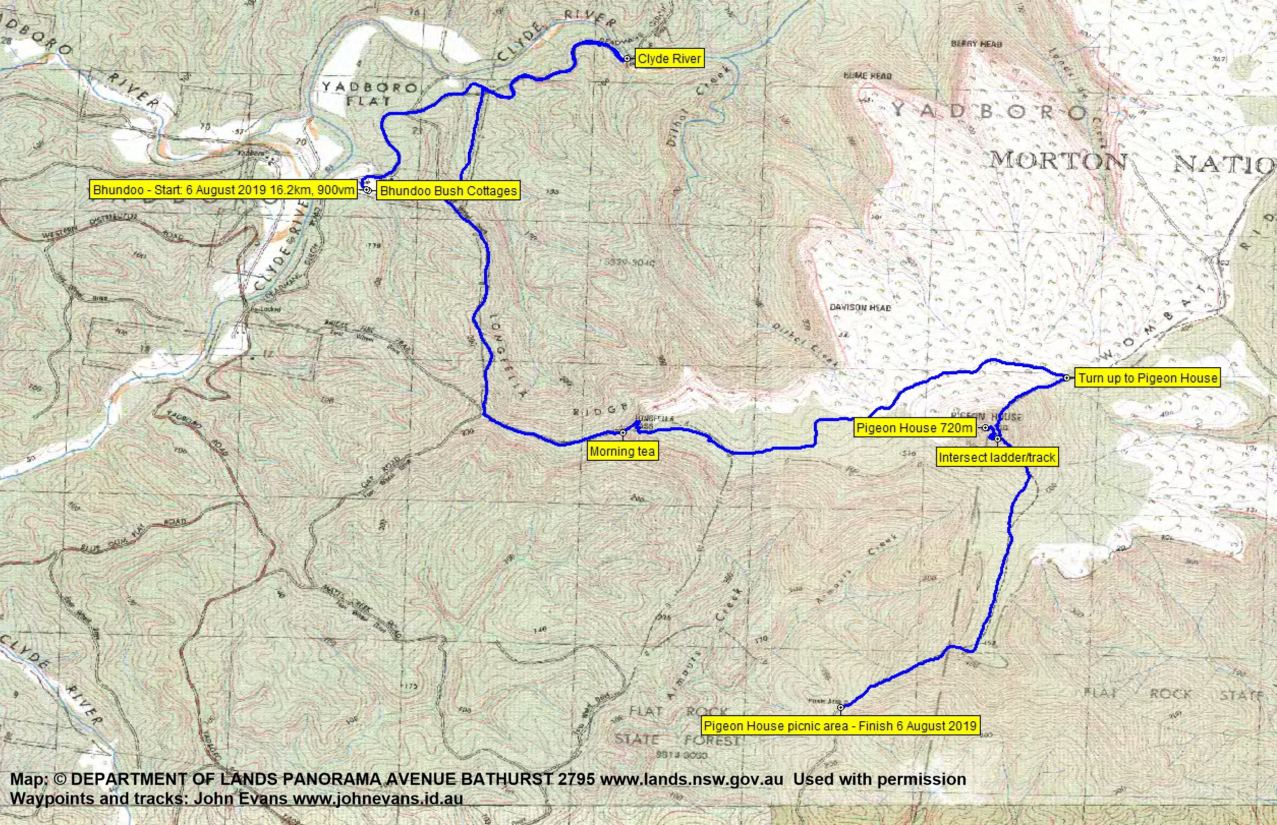
Walk 3 – Distance: 16.2km | Climb: 900m | Time: 7.40am – 4.15pm (8hrs 35mins) | Grading: L/R; H(13)
Photographs
Photographs are available, where you can start a large sized slideshow.
Video
Waypoint and Track Files
Download the gpx file for Walk 1 (if your browser does not automatically download the file, it will open the gpx file in a new window and you can then save it). To use in Google Earth, do File, Open… and select Gps or All files as the File Type.
Download the gpx file for Walk 2
Download the gpx file for Walk 3
Track Notes
Day 1
Whisked from my very door of my old folks home via coffee in Braidwood, lunch in Batemens Bay to Long Beach. Then via Princes Highway, Wheelbarrow Rd, Woodburn Rd, Clyde Ridge Rd, Yadboro Rd and Deadmans Gulch Rd to Bhundoo Bush Cottages.
Settled in to our accommodation with views to The Castle.

Mt Owen, The Castle and Byangee Walls from Bhundoo Bush Cottages
Walk 1
With the afternoon yet young, we went for a stroll further in along Deadmans Gulch Road to appreciate even grander views to Byangee Walls.

Byangee Walls from Bhundoo owners’ house

The bush beside Deadmans Gulch Rd

137m cliffs on the SE of Byangee Walls from Deadmans Gulch Rd
A great fire pit for pre-dinner drinks and nibbles, then a variety of cooking on open fire and in cottage kitchens.
In usual style, this old codger was early to bed.
Walk 1 Track Map
Day 2
A mild night (compared to the Canberra region). Up at 6.30am and ready to leave at 7.30am or thereabouts. We drove via Deadmans Gulch Rd, Western Distributor Rd and Long Gully Rd to the Long Gully camp ground.
Walk 2
Walking by 8am, I’d decided to take my chances on crossing the Yadboro River. When we arrived, no need for anyone’s crocs as the river was pretty low and just running at the crossing point.

Yadboro River crossing
A long pull up the old vehicle track from the river to the southern end of the lowest tier of The Castle, 2.4km rising 350vm in 1hr.

Walking up the fire trail paralleling Castle Creek
At last the feature came into clear view.

Southern end of The Castle lower tier comes into view
Thankfully, morning tea was called.

Morning tea
What followed was a magnificent cliff line base walk on footpad from the southern point of The Castle to Window Rock above Castle Gap.

Walking below the cliff line between morning tea and Castle Gap

Walking below the cliff line between morning tea and Castle Gap

Tree ferns below the cliff line between morning tea and Castle Gap

Walking below the cliff line between morning tea and Castle Gap

Byangee Walls and distant Pigeon House from our approach to Window Rock
There are many more photos.
We stopped above Castle Gap and doubled back to the left for a few tens of metres and scrambled up to Window Rock. Wonderful views!

The NW end of Byangee Walls through Window Rock

View up the east side of The Castle lower tier from Window Rock

The NW end of Byangee Walls and Window Rock
The next leg of 730m in 22mins took us down through Castle Gap and along under the NE part of Byangee Walls to the ascent point.

The bottom of the climb up Byangee Walls
It was a relatively easy climb (perhaps easier with long legs) with only three scramble sections and no real air. Perhaps it had been built up in my mind.
The first involved a steep rope assisted section.
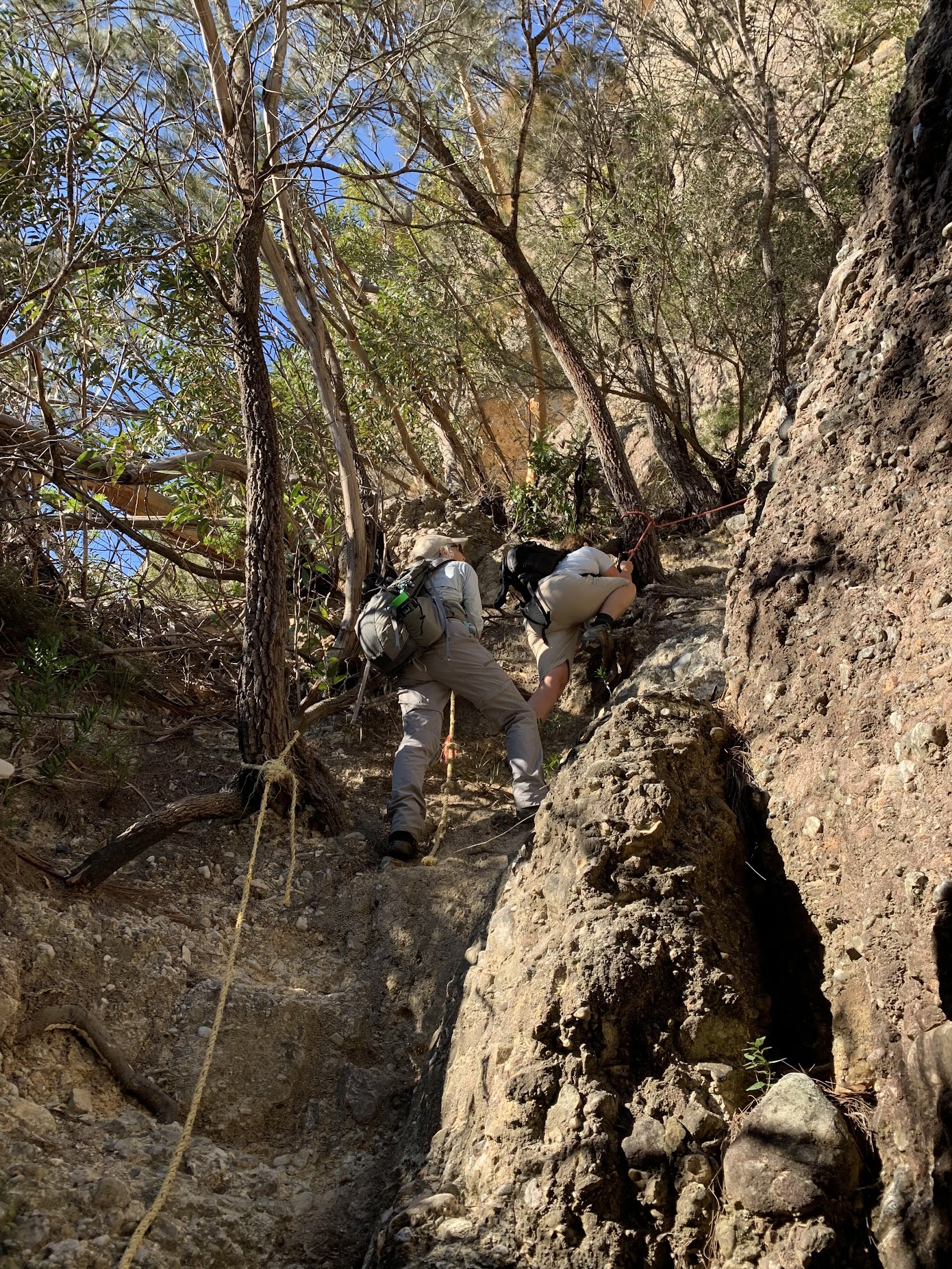
The first obstacle of the climb up Byangee Walls
The second a scramble up a fallen tree and over a boulder, again rope assisted. Pack passing was required.

The bottom of the second obstacle of the climb up Byangee Walls

The top of the second obstacle of the climb up Byangee Walls
A bit of relief between the second and third obstacles allowed us to appreciate the views.

The Castle from a flat section of the climb between obstacles two and three

The north side of the Byangee Mountain area from a flat section of the climb between obstacles two and three
The final obstacle required us to duck under a chock stone, wriggle up using back and feet against the walls and pop up through the top.

Approaching obstacle three
The climb was slow as we had a party of 13 and the obstacles took some time for us all to pass. Around 1hr 5mins. All was forgiven and forgotten as we took in the views during lunch.

The Castle and Shrouded Gods Mountain from lunch
A few of us then walked a bit of the top towards Byangee Mountain.

Walking the top of Byangee Walls
The stunning views were uninterrupted.

The Castle, Clyde River Gorge and Warre Head from the top of Byangee Walls
Our aim was to try to reach Pickering Point but time beat us. We turned about at the log book.

Pigeon House from the Byangee Walls log book
So it was basically reverse down and out.

Descending from the top of Byangee Walls
There was one more feature, the lofty Cathedral Cave on the SE base of The Castle.

Cathedral Cave

Tree ferns at the entrance to Cathedral Cave
Walk 2 Track Map

Same drill as the previous night, except I went to bed tirder and earlier and slept the whole night.
Day 3
Up at 6.30am again to a light frost.

Morning light on The Castle day 2 and a light frost
Away at 7.40am to first walk down to the Clyde River. 2.6km in 45mins.

Walking Deadmans Gulch Rd towards the Clyde River
It was cold and I had gloves and down jacket on for most of the morning, except for the steep climbs.

The Clyde River with Byangee Walls at back
We returned about half way to the cottages, then walked up to the south to join the fire trail running up Longfella Ridge. A couple of steep sections.

Cabbage tree palm
At a track junction we turned left and climbed east-ish up Bridle Fire Trail to below Longfella Pass. Another steep climb. Morning tea was called.
At this point the fire trail turned into a wide footpad (Ian said it was an old route used to move cattle – wow!) which climbed indirectly through the Pass.
At some stage we left the track to visit caves with aboriginal rock art. This part of the route has been removed from the map segment and gpx file, and relevant photos are not georeferenced in order to protect the location.

Caves west of Pigeon House

See through lung-like rock in cave west of Pigeon House

Rock art in cave west of Pigeon House

Rock art in cave west of Pigeon House

Grinding grooves below cave west of Pigeon House
There are many more photos.
We continued on an old fire trail across the N of Pigeon House.

Banksia
The first view of our objective was a little different to that seen by most others.

First view of Pigeon House from the west
From the NE we found the start of what was the original route up Pigeon House and began to climb.

The bottom of the old track up Pigeon House from the NE
It was steep, rising nearly 200 vertical metres in 650m. It took us 30mins.

Climbing the old track up Pigeon House from the NE
Reaching the base of the rock cap, we sidled round through E to SE to the bottom of the ladders.

Approaching the rocky top of Pigeon House from the NE
The ladders were in a lot better condition than in 2001!

Ascending the ladders up Pigeon House
As expected, huge views from the top!

The ocean from Pigeon House

View west to the Budawang and Morton National Parks from Pigeon House
After absorbing the views and arvo tea we walked down the regular track to the Pigeon House picnic area.

Ladder signage
The 490 vertical metre descent over 2.8km took 1 hour.
We were met by drivers with vehicles who had turned back during the day.
Walk 3 Track Map
Day 4
A relaxed start and a final view.

Morning view before we leave
The 63km drive back to Long Beach took 1hr 35mins, this time turning right onto Woodburn Rd and Monkey Mountain Rd to get us onto the Princes Highway at Termeil.
A good strong coffee (I’d been on decafe all the trip till now) and back to Canberra via lunch at Braidwood.
A dream trip come true for me. Many thanks Barry and all!
Party
8-14 walkers – Ian and Lynn B, Donna G and Tony, Barry K (leader) and Jill B, Rachel and Bruce K, Maggie M, Sharon McD, Quentin M, Lois P, Helen R, me.