
Negotiating a tight spur down to cross the rugged Valley Creek
Saturday 25 May: Cuumbeun Nature Reserve Wander – L/M,ptX. The Cuumbeun NR is just east of Queanbeyan and is primarily open eucalypt woodland, crossed by some deep ravines. This walk uses some of the Old Sydney Road which runs through the NR and other management trails, with a couple of forays off-track. Suitable for those who would like to extend from tracks to off-track walking. Includes a visit to Faunce Hill, Lazarus’s hut and 12 geocaches. Around 17km and 600m climb. Maps: Bungendore and Hoskinstown. Leader: John Evans 0417 436 877 john@johnevans.id.au . Transport: ∼$10 per person.
Further Information
This is Ian Wright country. Last here 1 Apr 14 and 7 Feb 17.
Summary
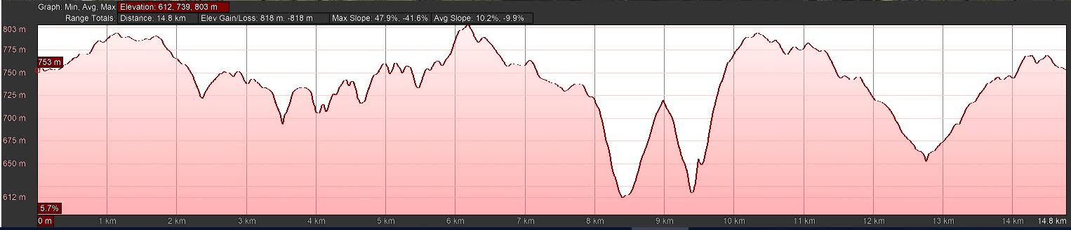
Distance: 14.8km | Climb: 800m | Time: 8.20am – 2.20pm (6hrs), including 35 mins of breaks | Grading: L/M-R; H(12-)
Photographs
Photographs are available, where you can start a large sized slideshow.
Waypoint and Track Files
Download the gpx file for this trip (if your browser does not automatically download the file, it will open the gpx file in a new window and you can then save it). To use in Google Earth, do File, Open… and select Gps or All files as the File Type.
Track Notes
We met at Spotlight in Queanbeyan and drove all of 6km to a point on the verge of Captains Flat Road.
A gate in the fence led us to a fire trail which headed SW past a small dam to intersect the Queanbeyan River Fire Trail (marked on my old 2006 digital maps as Old Sydney Road).

A small dam between the Captains Flat Rd and Old Sydney Rd (Queanbeyan River Fire Trail)
Then generally SE and E-ish, down through one gully, to Lazarus’s Hut.

Lazarus rising?
I found the history of this hut in Tim the Yowie Man’s book In the Spirit of Banjo, a compilation of Tim’s columns published in the Canberra Times. This one, called ‘Lazarus rising’ was first published 27 September 2013. It includes “… a ‘hut’ built by George Lazarus, a World War I veteran-turned-recluse who worked on a road gang with the Queanbeyan Council in the mid-1900s.”
MJW1 and I quickly found and logged the nearby geocache GC4H958 Wondrous Woodpile.
The next leg took us west off-track across a gully to the edge of a drop where we logged GC4H93Q Cuumbeun Cliffs.
Next, SE across two gullies to the main fire trail.
Heading down into one of the many gullies
Down to the bottom of yet another gully we logged GC81838 Cuumbeun Creek a metre off the FT.
Then SW along the fire trail, cutting the corner and heading up to Faunce Hill for morning tea. A quick find and log of GC7TQGT Faunce Facility.

Morning tea at Faunce Hill
Refreshed, we continued NW on the fire trail, popping in for Matthew to log GC4KNF8 Greenleigh Glimpse II, which I’d previously logged.Further on we both found and logged GC85N8N Faunce Foothill, then GC4KNEH Vultures View.
We headed off-track down to the next cache, Ian remarking that there was a mine shaft in the area.

At the mine shaft site | photo Denis Graham
Seeing as the cache was called Microwave Mineshaft, we guessed what we were heading for. The cache description warned us that the shaft was deep.

Mineshaft near geocache GC4H95H Microwave Mineshaft
Yet another quick find and log of GC4H95H Microwave Mineshaft.
We returned up the fire trail.
We’d had enough of fire trail, so our next leg took us via a steep and narrow spur down to cross the ravine in the upper part of Valley Creek.
The climb out was steep, 35mins for around 500m across the ground and 150m climb.

Beginning the climb back out of Valley Creek
The climb finally levelled out and we stopped for lunch as soon as we reached the Old Sydney Road.
Options reconsidered, we trundled around 2km further NW along the fire trail to find and log GC2C8Y1 24 months sabbatical. So close to Spotlight.

Walking the fire trails of Cuumbeun Nature Reserve | photo Denis Graham
Returned by fire trail, a little off-track, fire trail and finally off-track to the cars.
A good day with 8 caches. An excellent day with new and old friends. Hopefully a couple of new CBC members will result.
Track Map

Track
Profile
Party
13 walkers – Meghan B, Emily G, Denis G, Tim H, Braham H, Richard H, Stephen M, Terrylea R, Phillip S, Steve T, Matthew W, Ian W, me.
Davidp
26 May , 2019 9:29 pmWhat day of the week is the 35 th of May?
Johnny Boy
26 May , 2019 9:34 pm10 days after the 25th 🙂